Category:Maps of New London County, Connecticut
Jump to navigation
Jump to search
Wikimedia category | |||||
| Upload media | |||||
| Instance of | |||||
|---|---|---|---|---|---|
| Category combines topics | |||||
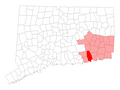
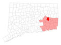
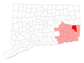
| New London County | |||||
county in Connecticut, United States   | |||||
| Instance of | |||||
| Named after | |||||
| Location | Connecticut | ||||
| Capital | |||||
| Inception |
| ||||
| Population |
| ||||
| Area |
| ||||
| Different from | |||||
 | |||||
Subcategories
This category has the following 4 subcategories, out of 4 total.
M
N
Media in category "Maps of New London County, Connecticut"
The following 43 files are in this category, out of 43 total.
-
-

-

-
 BattleOfGrotonHeightsSketch.jpg 3,443 × 5,066; 4.95 MB
-
 E Lyme CT lg.PNG 1,824 × 1,374; 109 KB
-
 Franklin CT lg.PNG 1,824 × 1,374; 110 KB
-
 Griswold CT lg.PNG 1,824 × 1,374; 109 KB
-

-
 Sanborn Fire Insurance Map from Groton, New London County, Connecticut. LOC sanborn01130 001.tif 6,450 × 7,650; 141.17 MB
-
 Ledyard CT lg.PNG 1,824 × 1,374; 110 KB
-
 Lisbon CT lg.PNG 1,824 × 1,374; 110 KB
-
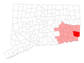
 Map of Connecticut highlighting New London County.svg 1,624 × 1,184; 16 KB
-
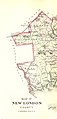
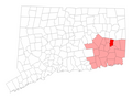
 Map of New London County Connecticut With Municipal Labels.PNG 678 × 510; 78 KB
-
 Montville CT lg.PNG 1,824 × 1,374; 110 KB
-
 N Stonington CT lg.PNG 1,824 × 1,374; 110 KB
-

-

-

-

-

-

-

-

-

-

-

-

-

-

-

-

-

-
-

-
 OxoboxoRiverCDP.gif 575 × 425; 54 KB
-
 Plan of the city of Norwich, New London County, Connt. (2674583752).jpg 7,944 × 9,310; 47.41 MB
-
 Preston CT lg.PNG 1,824 × 1,374; 110 KB
-
 Salem CT lg.PNG 1,824 × 1,374; 109 KB
-
 Sprague CT lg.PNG 1,824 × 1,374; 109 KB
-
 Stonington CT lg.PNG 1,824 × 1,374; 110 KB
-
 US-CT-Colchester.png 450 × 336; 38 KB
-
 US-CT-New London.png 450 × 336; 38 KB
-
 US-CT-Salem.png 450 × 338; 48 KB
.jpg)
.jpg)
.jpg)


_Highlighted.svg)

.jpg)


