Category:Maps of Munster, Ireland
Jump to navigation
Jump to search
Subcategories
This category has the following 4 subcategories, out of 4 total.
M
- Maps of County Limerick (14 F)
Media in category "Maps of Munster, Ireland"
The following 13 files are in this category, out of 13 total.
-
-
 BlankMunsterBaronies.png 1,981 × 1,533; 613 KB
-
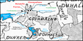 CoshmaingMap.png 1,501 × 754; 1.02 MB
-
 DesmondSepts.png 2,142 × 1,287; 2.31 MB
-
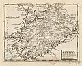
 East Munster in the 16th Century (Confiscation in Irish history).png 1,390 × 1,368; 166 KB
-
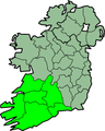
 Ireland location Munster.jpg 1,792 × 2,258; 713 KB
-
 IrelandMunster.png 200 × 249; 28 KB
-
 Kingdom of Ormond (circa 1111).png 806 × 608; 140 KB
-
 Kingdom of Ossory (circa 1111).png 806 × 608; 140 KB
-
 Kingdom of Thomond (circa 1111).png 806 × 608; 138 KB
-
 Munster - Synod of Rathbreasail (circa 1111).png 806 × 608; 141 KB
-
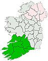
 Munster locator map.svg 1,264 × 1,649; 592 KB
-
 Ui Chonaill (circa 1111).png 806 × 608; 140 KB


.png)


.png)
.png)
.png)
.png)

.png)