<nowiki>Category:Maps of Miranda (state); categoría de Wikimedia; kategori Wikimedia; Wikimedia category; د ويکيمېډيا وېشنيزه; Vikimedya kategorisi; ویکیمیڈیا زمرہ; kategória projektov Wikimedia; категорія проєкту Вікімедіа; 维基媒体分类; Wikimedia-Kategorie; kategorie na projektech Wikimedia; Wikimedia-Kategorie; विकिपीडिया:श्रेणी; page de catégorie de Wikimedia; kategorija na Wikimediji; विकिपीडिया वर्ग; категорија на Викимедији; Wikimedia-Kategorie; Wikimedia-kategori; kategori Wikimédia; تصنيف ويكيميديا; pajenn rummata eus Wikimedia; Wikimedia:ကဏ္ဍခွဲခြင်း; 維基媒體分類; Wikimedia категориясы; categoría de Wikimedia; Wikimedia-Kategorie; Wikimedia-Kategorie; tudalen categori Wikimedia; kategori e Wikimedias; Վիքիմեդիայի նախագծի կատեգորիա; 维基媒体分类; Wikimedia-kategory; ვიკიპედია:კატეგორიზაცია; ウィキメディアのカテゴリ; categoria Wikimedia; تصنيف بتاع ويكيميديا; විකිමීඩියා ප්රභේද පිටුව; categoria Vicimediorum; Vikipidiya:Shopni; Wikimedia-luokka; Wikimedia-categorie; guruhi Vikimedia; катэгорыя ў праекце Вікімэдыя; Викимедиа проектындагы төркем; catigurìa di nu pruggettu Wikimedia; หน้าหมวดหมู่วิกิมีเดีย; Wikimedia:Kategorija; Wikimedia-Kategorie; Wikimedia:Klassys; категория на Уикимедия; categorie a unui proiect Wikimedia; 維基媒體分類; Wikimedia-kategori; kawan Wikimèdia; 維基媒體分類; 위키미디어 분류; Wikimedia-bólkur; kategorio en Vikimedio; kategori Wikimedia; categoría de Wikimedia; উইকিমিডিয়া বিষয়শ্রেণী; kategori Wikimedia; 维基媒体分类; וויקימעדיע קאַטעגאָריע; kategorija w projektach Wikimedije; thể loại Wikimedia; Wikimedia projekta kategorija; Wikimedia-kategorie; categoria de um projeto da Wikimedia; 维基媒体分类; категорияд Ангилал; Wikimedia-kategori; kategori Wikimedia; پۆلی ویکیمیدیا; Wikimedia category; Vikimédia ñemohenda; Wikimédia-kategória; વિકિપીડિયા શ્રેણી; Wikimediako kategoria; категория в проекте Викимедиа; Wikimedia-Kategorie; катэгорыя ў праекце Вікімедыя; Wikimedia-kategorie; Wîkîmediya:Kategorî; विकिमिडिया श्रेणी; Wikimedia-Kategorie; קטגוריה במיזמי ויקימדיה; Викимедиа проектындагы төркем; 维基媒体分类; विकिमिडिया श्रेणी; 維基媒體分類; Wikimedia-kategoriija; гурӯҳи Викимедиа; kategoria w projekcie Wikimedia; Wikimedia:Ronnaghys; Wikimedia-categorie; categoria di un progetto Wikimedia; விக்கிமீடியப் பகுப்பு; Wikimedia category; categurìa 'e nu pruggette Wikimedia; 維基媒體分類; Wikimedia category; Wikimedia-kategori; kategorya ng Wikimedia; гурӯҳи Викимедиа; ẹ̀ka Wikimedia; Викимедиина категорија; categoria de um projeto da Wikimedia; kategorija na Wikimediji; ردهٔ ویکیپدیا; tumbung Wikimedia; kategoria ti Wikimedia; kategorija Wikimedije; Wikimedia proyektındağı törkem; Викимедиа категорияһы; categoria de Wikimedia; kategori Wikimedia; jamii ya Wikimedia; വിക്കിമീഡിയ വർഗ്ഗം; Wikimedia-categorie; kategori Wikimedia; Viciméid catagóir; زمرو:وڪيپيڊيا زمرا بندي; Wikimedia kategooria; categoría de Wikimedia; विकिमीडिया श्रेणी; κατηγορία εγχειρημάτων Wikimedia; Kategoriya ning Wikimedia</nowiki>
This is a
main category requiring frequent
diffusion and maybe maintenance . As many pictures and media files as possible should be moved into appropriate subcategories.
Subcategories
This category has the following 7 subcategories, out of 7 total.


 Elecciones Gobernador Miranda 2008.svg 299 × 93; 57 KB
 Köppen Cordillera Costa Central.png 6,574 × 4,176; 826 KB
 MAPA 1 DIVISIÓN POLÍTICO-TERRITORIAL DEL MUNICIPIO BOLIVARIANO GUAICAIPURO.png 1,081 × 737; 317 KB
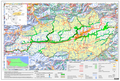
 MAPA 4 CUENCAS HIDROGRÁFICAS, PARACOTOS, GUAICAIPURO, MIRANDA, VENEZUELA.png 1,093 × 739; 943 KB
 MAPA 5 POTENCIAL EDÁFICO, PARACOTOS, GUAICAIPURO, MIRANDA, VENEZUELA.png 1,089 × 735; 974 KB
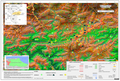 Mapa 6.png 1,081 × 731; 1.51 MB
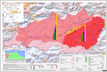 Mapa 7 Densidad Poblacional Paracotos, Guaicaipuro, Miranda, Venezuela.png 2,127 × 1,437; 1.9 MB
 Mapa de la Parroquia Paracotos.jpg 7,572 × 5,211; 12.79 MB
 Mapa electoral de Miranda de 2012.png 2,100 × 1,002; 217 KB
 OpenStreetMap of Los Teques.jpg 1,204 × 1,189; 317 KB
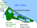 Parroquia Tacarigua de la Laguna.PNG 264 × 202; 11 KB
 Tacariagua de la LagunaU.PNG 134 × 137; 3 KB
 ZonaClimatica CordilleraCostaCentral.png 6,551 × 4,773; 1.48 MB


