Category:Maps of Meigs County, Ohio
Jump to navigation
Jump to search
Wikimedia category | |||||
| Upload media | |||||
| Instance of | |||||
|---|---|---|---|---|---|
| Category combines topics | |||||
| Meigs County | |||||
county in Ohio, United States of America    | |||||
| Instance of | |||||
| Named after | |||||
| Location | Ohio | ||||
| Capital | |||||
| Inception |
| ||||
| Population |
| ||||
| Area |
| ||||
| Different from | |||||
 | |||||
Meigs County is in Ohio in the United States. Its county seat is Pomeroy.
Subcategories
This category has the following 2 subcategories, out of 2 total.
Media in category "Maps of Meigs County, Ohio"
The following 19 files are in this category, out of 19 total.
-
 Forked run sp - shade river sf.gif 2,304 × 3,456; 635 KB
-
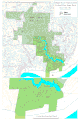
 Leading Creek Ohio map.png 2,763 × 2,378; 232 KB
-
 Map of Gallia and Meigs County oil field LOC 2012591125.jpg 8,387 × 11,221; 13.84 MB
-
 Map of Gallia and Meigs County oil field LOC 2012591125.tif 8,387 × 11,221; 269.25 MB
-
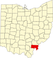 Map of Ohio highlighting Meigs County.svg 3,675 × 3,995; 58 KB
-
 Morganmap.jpg 433 × 441; 37 KB
-
 OHMap-doton-Chester.png 309 × 352; 17 KB
-
 OHMap-doton-Darwin.png 309 × 352; 17 KB
-
 OHMap-doton-Langsville.png 309 × 352; 17 KB
-
 OHMap-doton-Long Bottom.png 309 × 352; 17 KB
-
 OHMap-doton-Middleport.png 274 × 300; 10 KB
-
 OHMap-doton-Pomeroy.png 274 × 300; 10 KB
-
 OHMap-doton-Portland.png 309 × 352; 17 KB
-
 OHMap-doton-Racine.png 274 × 300; 10 KB
-
 OHMap-doton-Reedsville.png 309 × 352; 17 KB
-
 OHMap-doton-Rutland.png 274 × 300; 10 KB
-
 OHMap-doton-Syracuse.png 274 × 300; 10 KB
-
 OHMap-doton-Tuppers Plains.png 309 × 352; 17 KB
-
 Shade River map.png 2,763 × 2,378; 273 KB


