Category:Maps of Mecklenburg
Jump to navigation
Jump to search
Wikimedia category | |||||
| Upload media | |||||
| Instance of | |||||
|---|---|---|---|---|---|
| Category combines topics | |||||
| Mecklenburg | |||||
historical region in northern Germany     | |||||
| Instance of | |||||
| Named after | |||||
| Location |
| ||||
| Replaced by | |||||
 | |||||
Subcategories
This category has the following 7 subcategories, out of 7 total.
M
- Maps of Mecklenburg-Schwerin (13 F)
- Maps of Mecklenburg-Strelitz (13 F)
P
- Maps of Parchim (5 F)
R
S
Media in category "Maps of Mecklenburg"
The following 29 files are in this category, out of 29 total.
-
 Mecklenburg-Vorpommern districts 2011 colored labeled Meck-Pomm-border.svg 1,129 × 775; 684 KB
-
 Bishopric of Ratzeburg locator map (1250).svg 990 × 780; 3.14 MB
-
 Bishopric of Schwerin locator map (1250).svg 990 × 780; 3.14 MB
-
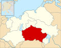
 County of Schwerin locator map (1250).svg 990 × 780; 3.14 MB
-
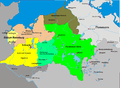
 Duchy of Mecklenburg-Schwerin (1812).svg 450 × 456; 611 KB
-
 First partition of Mecklenburg-es.svg 990 × 780; 3.22 MB
-
 First partition of Mecklenburg.svg 990 × 780; 3.14 MB
-
 Geognostische Doemitz Koch 1856.jpg 1,630 × 1,060; 394 KB
-
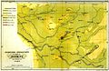
 Geognostische Karte SW Mecklenburg Sabban 1896.jpg 1,615 × 1,097; 437 KB
-
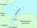 Karte - Lübecker Bucht - Lübecker-Bucht-Fall - 2.png 896 × 687; 115 KB
-
 Karte - Lübecker Bucht - Lübecker-Bucht-Fall - 3.png 896 × 687; 116 KB
-
 Karte - Lübecker Bucht - Lübecker-Bucht-Fall.png 896 × 687; 96 KB
-
 Karte-Mecklenburg 1250.PNG 2,437 × 1,787; 213 KB
-
 Karte-Mecklenburg 1300.png 1,200 × 880; 531 KB
-
 Lageplan Buchholz (Goldberg).jpg 3,228 × 2,217; 1.04 MB
-
 Lordship of Mecklenburg locator map (1250).svg 990 × 780; 3.14 MB
-
 Lordship of Parchim locator map (1250).svg 990 × 780; 3.14 MB
-
 Lordship of Rostock locator map (1250).svg 990 × 780; 3.14 MB
-
 Lordship of Werle locator map (1250).svg 990 × 780; 3.14 MB
-
 Mecklenburg 1648.jpg 527 × 355; 367 KB
-
-
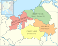
 Mecklenburg-Werle 1300.PNG 2,437 × 1,787; 222 KB
-
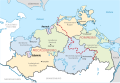
 Municipalities in LRO.svg 815 × 697; 1.16 MB
-
 Municipalities in LUP.svg 1,040 × 654; 757 KB
-
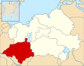
 Municipalities in MBS cropped.png 1,233 × 895; 3.16 MB
-
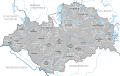
 Municipalities in MBS.svg 896 × 804; 714 KB
-
 Municipalities in NWM 2011.svg 644 × 460; 1.07 MB
-
 Napoleonic Central Europe.jpg 3,937 × 2,855; 2.85 MB
-
 Окрузи во Западна Померанија 2011.svg 1,129 × 775; 926 KB

.svg)
.svg)
.svg)
.svg)


.jpg)
.svg)
.svg)
.svg)
.svg)


