Category:Maps of Lake Ontario
Jump to navigation
Jump to search
Wikimedia category | |||||
| Upload media | |||||
| Instance of | |||||
|---|---|---|---|---|---|
| Category combines topics | |||||
| Lake Ontario | |||||
one of the Great Lakes in North America .jpg)   | |||||
| Instance of | |||||
| Part of | |||||
| Location | |||||
| Has part(s) |
| ||||
| Width |
| ||||
| Length |
| ||||
| Area |
| ||||
| Elevation above sea level |
| ||||
| Inflows |
| ||||
| Outflows | |||||
| Drainage basin |
| ||||
| Basin country | |||||
 | |||||
Subcategories
This category has the following 4 subcategories, out of 4 total.
- Maps of the Toronto Islands (2 F)
O
Media in category "Maps of Lake Ontario"
The following 38 files are in this category, out of 38 total.
-
 Another NOAA map of Lake Ontario.jpg 5,308 × 3,638; 1.85 MB
-
 Bay of Quinte, NOAA.jpg 3,092 × 1,680; 906 KB
-
 Breeze - Toronto, Rochester ferry.png 514 × 298; 12 KB
-
 Chippewa and Stanley Low Levels (Larsen 1987).jpg 1,287 × 961; 125 KB
-
 Communities of the Greater Toronto Area 2.png 514 × 435; 8 KB
-
 Drumlinfield large.jpg 700 × 947; 161 KB
-
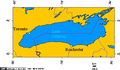
 East End of Lake Ontario.png 1,623 × 773; 616 KB
-
 Fig 10 Diagram of Lake Ontario.jpg 462 × 284; 22 KB
-

-
 Genticore plate, Upper Canada.png 1,280 × 800; 1.27 MB
-
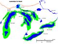
 Great Lakes bathymetry map 2.png 1,024 × 731; 943 KB
-
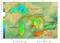 Great Lakes bathymetry map.png 1,024 × 731; 1.34 MB
-
 Great Lakes Lake Ontario.png 581 × 406; 10 KB
-
 Great Lakes Lake Superior.png 581 × 406; 10 KB
-
 Great Lakes Seaway Trail - Map of the Seaway Trail - NARA - 7718835.jpg 1,662 × 1,275; 435 KB
-
 Huronie.JPG 900 × 674; 132 KB
-

-
 Irondequoit Bay, NY State.gif 764 × 695; 47 KB
-
 Jmse-04-00046-g001-1024.png 515 × 1,024; 332 KB
-
 Lake Ontario bathymetry map 2.png 1,024 × 656; 470 KB
-
 Lake Ontario bathymetry map.png 1,024 × 656; 750 KB
-
 Lake Ontario Watershed.png 435 × 355; 53 KB
-
 Lake-Ontario-red.png 786 × 533; 59 KB
-
 Lake-Ontario.svg 786 × 533; 74 KB
-
 Lake-Superior-red.png 786 × 533; 54 KB
-

-

-
 NOAA bathymetric map of Lake Ontario's Rochester Basin.jpg 2,820 × 2,012; 4.61 MB
-
 NOAA Bathymetric map of the Niagara Basin.jpg 2,504 × 1,908; 2.59 MB
-
 NOAA bathymetric map of the Niagara Fan.jpg 2,211 × 1,527; 1.28 MB
-
 NOAA bathymetric map of the West and East Kingston Basins.jpg 3,012 × 2,032; 3.78 MB
-
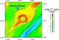 NOAA map of Charity Shoal in Lake Ontario.jpg 2,340 × 1,596; 1.51 MB
-

-
 NOAA map of Duck Galloo Ridge.jpg 2,736 × 2,228; 3.47 MB
-
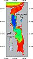 NOAA map of Irondequoit Bay.jpg 1,315 × 2,280; 654 KB
-
 NOAA map of Scotch Bonnet Ridge.jpg 3,096 × 2,108; 5.17 MB
-
 Ontario outline.gif 50 × 25; 1 KB
-
 Ports Colbourne, Weller, Maitland.PNG 514 × 774; 10 KB


.jpg)


,_10_to_20_fathoms.jpeg)


_1866-1912_(1915)_(14583464409).jpg)


_-_NARA_-_68886953_(page_7).jpg)


_showing_Timber,_Swetman,_Main_Duck_and_Yorkshire_islands,_and_some_subsurface_shoals.jpg)


