Category:Maps of KwaZulu-Natal municipalities with 2016 borders
Jump to navigation
Jump to search
This category contains maps of municipalities in KwaZulu-Natal province of South Africa that show the the municipal borders as they are after the municipal election of 3 August 2016. This is the most recent demarcation.
Media in category "Maps of KwaZulu-Natal municipalities with 2016 borders"
The following 70 files are in this category, out of 70 total.
-
 Map of KwaZulu-Natal with districts labelled (2016).svg 712 × 805; 800 KB
-

-
 Map of KwaZulu-Natal with municipalities blank (2016).svg 712 × 805; 1.7 MB
-
 Map of KwaZulu-Natal with Abaqulusi highlighted (2016).svg 712 × 805; 701 KB
-
 Map of KwaZulu-Natal with Alfred Duma highlighted (2016).svg 712 × 805; 704 KB
-
 Map of KwaZulu-Natal with Amajuba highlighted (2016).svg 712 × 805; 703 KB
-
 Map of South Africa with Amajuba highlighted (2016).svg 809 × 709; 696 KB
-
 Map of KwaZulu-Natal with Big Five Hlabisa highlighted (2016).svg 712 × 805; 706 KB
-
 Blank map of KwaZulu-Natal (2016).svg 663 × 754; 640 KB
-
 Map of KwaZulu-Natal with Dannhauser highlighted (2016).svg 712 × 805; 693 KB
-

-
 Map of KwaZulu-Natal with eDumbe highlighted (2016).svg 712 × 805; 698 KB
-
 Map of KwaZulu-Natal with eMadlangeni highlighted (2016).svg 712 × 805; 705 KB
-
 Map of KwaZulu-Natal with Endumeni highlighted (2016).svg 712 × 805; 692 KB
-
 Map of KwaZulu-Natal with eThekwini highlighted (2016).svg 712 × 805; 702 KB
-
 Map of South Africa with eThekwini highlighted (2016).svg 809 × 709; 694 KB
-
 Map of KwaZulu-Natal with Greater Kokstad highlighted (2016).svg 712 × 805; 702 KB
-
 Map of KwaZulu-Natal with Harry Gwala highlighted (2016).svg 712 × 805; 722 KB
-
 Map of South Africa with Harry Gwala highlighted (2016).svg 809 × 709; 701 KB
-
 Map of KwaZulu-Natal with iLembe highlighted (2016).svg 712 × 805; 717 KB
-
 Map of South Africa with iLembe highlighted (2016).svg 809 × 709; 699 KB
-
 Map of KwaZulu-Natal with Impendle highlighted (2016).svg 712 × 805; 695 KB
-
 Map of KwaZulu-Natal with iNkosi Langalibalele highlighted (2016).svg 712 × 805; 699 KB
-
 Map of KwaZulu-Natal with Jozini highlighted (2016).svg 712 × 805; 704 KB
-
 Map of KwaZulu-Natal with King Cetshwayo highlighted (2016).svg 712 × 805; 726 KB
-
 Map of South Africa with King Cetshwayo highlighted (2016).svg 809 × 709; 702 KB
-
 Map of KwaZulu-Natal with KwaDukuza highlighted (2016).svg 712 × 805; 694 KB
-
 Map of KwaZulu-Natal with Mandeni highlighted (2016).svg 712 × 805; 694 KB
-

-
 Map of KwaZulu-Natal with Maphumulo highlighted (2016).svg 712 × 805; 699 KB
-
 Map of KwaZulu-Natal with Mkhambathini highlighted (2016).svg 712 × 805; 696 KB
-
 Map of KwaZulu-Natal with Mpofana highlighted (2016).svg 712 × 805; 692 KB
-
 Map of KwaZulu-Natal with Msinga highlighted (2016).svg 712 × 805; 701 KB
-
 Map of KwaZulu-Natal with Msunduzi highlighted (2016).svg 712 × 805; 692 KB
-
 Map of KwaZulu-Natal with Mthonjaneni highlighted (2016).svg 712 × 805; 697 KB
-
 Map of KwaZulu-Natal with Mtubatuba highlighted (2016).svg 712 × 805; 696 KB
-
 Map of KwaZulu-Natal with Ndwedwe highlighted (2016).svg 712 × 805; 698 KB
-
 Map of KwaZulu-Natal with Newcastle highlighted (2016).svg 712 × 805; 700 KB
-
 Map of KwaZulu-Natal with Nkandla highlighted (2016).svg 712 × 805; 706 KB
-
 Map of KwaZulu-Natal with Nongoma highlighted (2016).svg 712 × 805; 706 KB
-
 Map of KwaZulu-Natal with Nquthu highlighted (2016).svg 712 × 805; 704 KB
-
 Map of KwaZulu-Natal with Okhahlamba highlighted (2016).svg 712 × 805; 702 KB
-
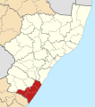
 Map of KwaZulu-Natal with Ray Nkonyeni highlighted (2016).svg 712 × 805; 703 KB
-
 Map of KwaZulu-Natal with Richmond highlighted (2016).svg 712 × 805; 695 KB
-
 Map of KwaZulu-Natal with Ubuhlebezwe highlighted (2016).svg 712 × 805; 699 KB
-
 Map of KwaZulu-Natal with Ugu highlighted (2016).svg 712 × 805; 719 KB
-
 Map of South Africa with Ugu highlighted (2016).svg 809 × 709; 699 KB
-
 Map of KwaZulu-Natal with Ulundi highlighted (2016).svg 712 × 805; 703 KB
-
 Map of KwaZulu-Natal with Umdoni highlighted (2016).svg 712 × 805; 694 KB
-
 Map of KwaZulu-Natal with uMfolozi highlighted (2016).svg 712 × 805; 696 KB
-
 Map of KwaZulu-Natal with uMgungundlovu highlighted (2016).svg 712 × 805; 719 KB
-
 Map of South Africa with uMgungundlovu highlighted (2016).svg 809 × 709; 701 KB
-
 Map of KwaZulu-Natal with uMhlabuyalingana highlighted (2016).svg 712 × 805; 705 KB
-
 Map of KwaZulu-Natal with uMhlathuze highlighted (2016).svg 712 × 805; 697 KB
-
 Map of KwaZulu-Natal with uMkhanyakude highlighted (2016).svg 712 × 805; 716 KB
-
 Map of South Africa with uMkhanyakude highlighted (2016).svg 809 × 709; 700 KB
-
 Map of KwaZulu-Natal with uMlalazi highlighted (2016).svg 712 × 805; 708 KB
-
 Map of KwaZulu-Natal with uMngeni highlighted (2016).svg 712 × 805; 691 KB
-
 Map of KwaZulu-Natal with uMshwathi highlighted (2016).svg 712 × 805; 698 KB
-
 Map of KwaZulu-Natal with uMuziwabantu highlighted (2016).svg 712 × 805; 699 KB
-
 Map of KwaZulu-Natal with Umvoti highlighted (2016).svg 712 × 805; 705 KB
-
 Map of KwaZulu-Natal with Umzimkhulu highlighted (2016).svg 712 × 805; 705 KB
-
 Map of KwaZulu-Natal with uMzinyathi highlighted (2016).svg 712 × 805; 721 KB
-
 Map of South Africa with uMzinyathi highlighted (2016).svg 809 × 709; 702 KB
-
 Map of KwaZulu-Natal with Umzumbe highlighted (2016).svg 712 × 805; 700 KB
-
 Map of KwaZulu-Natal with uPhongolo highlighted (2016).svg 712 × 805; 700 KB
-
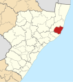
 Map of KwaZulu-Natal with uThukela highlighted (2016).svg 712 × 805; 707 KB
-
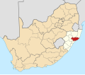
 Map of South Africa with uThukela highlighted (2016).svg 809 × 709; 698 KB
-
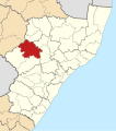
 Map of KwaZulu-Natal with Zululand highlighted (2016).svg 712 × 805; 722 KB
-
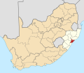
 Map of South Africa with Zululand highlighted (2016).svg 809 × 709; 701 KB
.svg)
.svg)
.svg)
.svg)
.svg)
.svg)
.svg)
.svg)
.svg)
.svg)
.svg)
.svg)
.svg)
.svg)
.svg)
.svg)
.svg)
.svg)
.svg)
.svg)
.svg)
.svg)
.svg)
.svg)
.svg)
.svg)
.svg)
.svg)
.svg)
.svg)
.svg)
.svg)
.svg)
.svg)
.svg)
.svg)
.svg)
.svg)
.svg)
.svg)
.svg)
.svg)
.svg)
.svg)
.svg)
.svg)
.svg)
.svg)
.svg)
.svg)
.svg)
.svg)
.svg)
.svg)
.svg)
.svg)
.svg)
.svg)
.svg)
.svg)
.svg)
.svg)
.svg)
.svg)
.svg)
.svg)
.svg)
.svg)
.svg)
.svg)