Category:Maps of Kurdish-inhabited regions in Iran
Jump to navigation
Jump to search
Media in category "Maps of Kurdish-inhabited regions in Iran"
The following 11 files are in this category, out of 11 total.
-
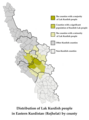 Distribution of Lak Kurdish people in Eastern Kurdistan (Rojhelat) by county.png 1,550 × 2,084; 509 KB
-
 Hamadan Province Ethnic Map.png 1,100 × 947; 37 KB
-
 Iran Ethnic Hafeznia.jpg 2,200 × 1,700; 1.11 MB
-

-
 Kurdish lands 92 (margins cropped).jpg 988 × 1,073; 387 KB
-
 Kurdish lands 92.jpg 1,066 × 1,138; 230 KB
-
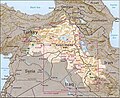
 Kurdish-inhabited area by CIA (1992) box inset removed.jpg 975 × 795; 556 KB
-
 Kurdish-inhabited area by CIA (1992).jpg 982 × 802; 630 KB
-
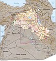
 Kurdish-inhabited area by CIA (2002).jpg 500 × 448; 38 KB
-
 Kurdistan province linguistic map.png 1,525 × 860; 52 KB
-
 West Azerbaijan Province Ethnic Map Detailed.png 1,143 × 1,673; 58 KB
_by_county.png)


.jpg)

_box_inset_removed.jpg)
.jpg)
.jpg)

