Category:Maps of India during World War II
Jump to navigation
Jump to search
Media in category "Maps of India during World War II"
The following 9 files are in this category, out of 9 total.
-
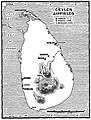 B-29 airfields in Ceylon.jpg 1,341 × 1,773; 838 KB
-
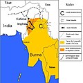
 Burma II - VI 1944.svg 377 × 536; 89 KB
-
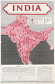 India Art.IWMPST15887.jpg 477 × 723; 106 KB
-
 Japanese Conquest of Burma April-May 1942.jpg 493 × 800; 89 KB
-
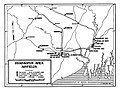 Kharagpur Area Airfields.jpg 1,960 × 1,478; 504 KB
-
 Kohima.jpg 536 × 535; 108 KB
-
 Kohimamagyar.jpg 536 × 535; 44 KB
-
 Map of India Burma Theatre.jpg 2,512 × 1,920; 1.18 MB
-
 Pacific War - Southern Asia 1942 - Map.jpg 1,260 × 961; 183 KB


