<nowiki>Category:Maps of Hamburg-Groß Flottbek; categoría de Wikimedia; kategori Wikimedia; Wikimedia category; د ويکيمېډيا وېشنيزه; Vikimedya kategorisi; ویکیمیڈیا زمرہ; kategória projektov Wikimedia; категорія проєкту Вікімедіа; 维基媒体分类; Wikimedia-Kategorie; kategorie na projektech Wikimedia; kategorija na Wikimediji; विकिपीडिया:श्रेणी; page de catégorie de Wikimedia; kategorija na Wikimediji; विकिपीडिया वर्ग; категорија на Викимедији; Wikimedia-Kategorie; Wikimedia-kategori; kategori Wikimédia; تصنيف ويكيميديا; pajenn rummata eus Wikimedia; Wikimedia:ကဏ္ဍခွဲခြင်း; 維基媒體分類; Wikimedia категориясы; categoría de Wikimedia; Wikimedia-Kategorie; Викимедиа категорияһы; tudalen categori Wikimedia; kategori e Wikimedias; ردهٔ ویکیپدیا; 维基媒体分类; Wikimedia-kategori; ვიკიპედია:კატეგორიზაცია; ウィキメディアのカテゴリ; categoria Wikimedia; تصنيف بتاع ويكيميديا; විකිමීඩියා ප්රභේද පිටුව; categoria Vicimediorum; Vikipidiya:Shopni; Wikimedia-luokka; Wikimedia-categorie; விக்கிமீடியப் பகுப்பு; катэгорыя ў праекце Вікімэдыя; Викимедиа проектындагы төркем; catigurìa di nu pruggettu Wikimedia; หน้าหมวดหมู่วิกิมีเดีย; Wikimedia:Kategorija; Wikimedia-Kategorie; Wikimedia:Klassys; категория на Уикимедия; categorie a unui proiect Wikimedia; 維基媒體分類; Wikimedia-kategori; kawan Wikimèdia; гурӯҳи Викимедиа; 위키미디어 분류; Wikimedia-bólkur; kategorio en Vikimedio; kategori Wikimedia; categoría de Wikimedia; উইকিমিডিয়া বিষয়শ্রেণী; kategori Wikimedia; 维基媒体分类; וויקימעדיע קאַטעגאָריע; kategorija w projektach Wikimedije; thể loại Wikimedia; Wikimedia projekta kategorija; Wikimedia-kategorie; categoria de um projeto da Wikimedia; Wikimedia category; категорияд Ангилал; Wikimedia-kategori; kategori Wikimedia; پۆلی ویکیمیدیا; Wikimedia category; Vikimédia ñemohenda; Wikimédia-kategória; વિકિપીડિયા શ્રેણી; Wikimediako kategoria; категория в проекте Викимедиа; Wikimedia-Kategorie; катэгорыя ў праекце Вікімедыя; Wikimedia-kategorie; Wîkîmediya:Kategorî; विकिमिडिया श्रेणी; Wikimedia-Kategorie; קטגוריה במיזמי ויקימדיה; Викимедиа проектындагы төркем; categoria de Wikimedia; विकिमिडिया श्रेणी; κατηγορία εγχειρημάτων Wikimedia; Wikimedia-kategoriija; гурӯҳи Викимедиа; kategoria w projekcie Wikimedia; Wikimedia:Ronnaghys; Wikimedia-categorie; categoria di un progetto Wikimedia; Kategoriya ning Wikimedia; 维基媒体分类; categurìa 'e nu pruggette Wikimedia; Wikimedia kategooria; Wikimedia category; 維基媒體分類; Wikimedia proyektındağı törkem; 維基媒體分類; ẹ̀ka Wikimedia; Викимедиина категорија; categoria de um projeto da Wikimedia; Wikimedia-Kategorie; Wikimedia-kategory; tumbung Wikimedia; kategoria ti Wikimedia; kategorija Wikimedie; kategorya ng Wikimedia; Wikimedia-Kategorie; Wikimedia-categorie; kategori Wikimedia; jamii ya Wikimedia; വിക്കിമീഡിയ വർഗ്ഗം; 維基媒體分類; kategori Wikimedia; Viciméid catagóir; زمرو:وڪيپيڊيا زمرا بندي; Վիքիմեդիայի նախագծի կատեգորիա; categoría de Wikimedia; विकिमीडिया श्रेणी; 维基媒体分类; guruhi Vikimedia</nowiki>


 Groß Flottbek in HH.svg 1,713 × 1,689; 780 KB
 Karte Röbbek um 1900.png 640 × 457; 618 KB
 Wedelerau aus Joh Mejer Stormarn 1650.png 1,095 × 751; 1.62 MB
 Varendorf(62)Altona Hamburg Harburg.jpg 3,565 × 3,602; 15.77 MB
 Hamburg 1790 Elbinseln Varendorf.jpg 3,785 × 2,836; 9.89 MB
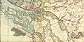 Hamburg 1790 große karte varendorf.jpg 7,040 × 3,530; 24.56 MB
 Karte hamburg 1790 varendorf kl.jpg 2,000 × 1,003; 1.28 MB
 1890 - Norddeutsche Staaten.jpg 3,170 × 1,825; 5.73 MB
 Hamburg 1898 Meyers 5. Aufl..jpg 3,176 × 2,480; 7.3 MB
 Meyers b8 s0038a.jpg 3,184 × 2,490; 7.07 MB
 Hamburg 1905 Meyers 6. Aufl..jpg 3,193 × 2,479; 7.88 MB
 Flottbek 1789.JPG 3,000 × 2,000; 1.35 MB
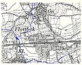 Flottbek Röbbek 1905.jpg 604 × 480; 186 KB
 Hamburg Altona Groß Flottbek.svg 229 × 186; 1.8 MB
 Hamburg Stadtteil Groß Flottbek.svg 560 × 549; 635 KB
 Pincerno - Groß Flottbek 11-2008.PNG 1,267 × 1,333; 48 KB
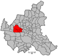 Hamburg Wahlkreis 3.png 1,186 × 1,144; 28 KB

Altona_Hamburg_Harburg.jpg)


