Category:Maps of Gloucester, Massachusetts
Jump to navigation
Jump to search
Wikimedia category | |||||
| Upload media | |||||
| Instance of | |||||
|---|---|---|---|---|---|
| Category combines topics | |||||
| Gloucester | |||||
city on Cape Ann in Essex County, Massachusetts, United States   | |||||
| Instance of | |||||
| Part of | |||||
| Location | Essex County, Massachusetts | ||||
| Has part(s) |
| ||||
| Inception |
| ||||
| Population |
| ||||
| Area |
| ||||
| Elevation above sea level |
| ||||
| Different from | |||||
| official website | |||||
 | |||||
Subcategories
This category has only the following subcategory.
Media in category "Maps of Gloucester, Massachusetts"
The following 27 files are in this category, out of 27 total.
-

-
 1851 map Gloucester RockportMA byHFWalling BPL M8699.png 866 × 649; 1,019 KB
-
 1851 map GloucesterMA byHFWalling BPL M8699.png 977 × 716; 1.19 MB
-

-
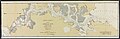
 1859 Gloucester Harbour, Village (2675625252).jpg 2,000 × 1,455; 2.43 MB
-
 1873 map GloucesterMA byFranklinLith BPL 10186.png 930 × 713; 1.04 MB
-
 1884 map of Dale Ave area in Gloucester Massachusetts USA Hopkins plate3.jpg 6,701 × 4,473; 3.31 MB
-
 1884 map of Harbor Cove area in Gloucester Massachusetts USA Hopkins plate2.jpg 6,697 × 4,473; 3.89 MB
-
 1884 map of Inner Harbor area in Gloucester Massachusetts USA Hopkins plate5.jpg 6,709 × 4,469; 3.27 MB
-
 1884 map of Main Street area in Gloucester Massachusetts USA Hopkins plate4.jpg 6,685 × 4,473; 3.6 MB
-
 1884 map of Smith Cove area in East Gloucester Massachusetts USA Hopkins plate6.jpg 6,709 × 4,473; 3.81 MB
-
 1884 map of Western Harbor area in Gloucester Massachusetts USA Hopkins plate1.jpg 6,693 × 4,469; 3.22 MB
-
 1887 map Magnolia GloucesterMA byGHWalker BPL M8694.png 5,583 × 3,702; 32.8 MB
-
-
 1919 map GloucesterMA SampsonMurdock BPL 12800 detail.png 1,027 × 643; 1.05 MB
-
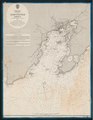
 Admiralty Chart No 2882 Massachusetts Gloucester Harbour, published 1862.jpg 8,398 × 10,814; 11.29 MB
-
 Admiralty Chart No 2896 Massachusetts Ipswich & Annisquam Harbours, Published 1862.jpg 8,956 × 5,991; 9.49 MB
-
 Annisquam River (Massachusetts) map.jpg 1,700 × 2,800; 1.43 MB
-
 City of Gloucester, Mass. (2676094458).jpg 2,000 × 1,452; 2.81 MB
-
-
 Gloucester Harbor, Massachusetts LOC 79695325.jpg 4,570 × 5,948; 4.59 MB
-
 Gloucester Harbor, Massachusetts LOC 79695325.tif 4,570 × 5,948; 77.77 MB
-
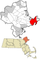
 Gloucester ma highlight.png 788 × 466; 54 KB
-
 Lobster Cove, Annisquam, Essex County, Massachusetts.jpg 8,262 × 6,645; 12.16 MB
-

-
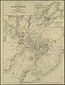 Map of the city of Gloucester, Mass. (3369694195).jpg 1,528 × 2,000; 3.28 MB
-


.jpg)


_map.jpg)
.jpg)


_by_Samuel_de_Champlain,_from_Les_Voyages,_Paris,_1613_-_Cape_Ann_Museum_-_Gloucester,_MA_-_DSC01073.jpg)
.jpg)