Category:Maps of French Indochina
Jump to navigation
Jump to search
Wikimedia category | |||||
| Upload media | |||||
| Instance of | |||||
|---|---|---|---|---|---|
| Category combines topics | |||||
| French Indochina | |||||
Federal state in Southeast Asia     .svg) | |||||
| Instance of |
| ||||
| Part of |
| ||||
| Location |
| ||||
| Capital |
| ||||
| Basic form of government | |||||
| Currency |
| ||||
| Inception |
| ||||
| Dissolved, abolished or demolished date |
| ||||
| Population |
| ||||
| Area |
| ||||
| Replaces |
| ||||
| Different from | |||||
 | |||||
Subcategories
This category has the following 11 subcategories, out of 11 total.
Media in category "Maps of French Indochina"
The following 178 files are in this category, out of 178 total.
-
 '1928 Indochine.jpg 6,056 × 8,436; 8.71 MB
-
 080 hinterindien-und-malaien-archipel (1905).png 2,247 × 1,776; 2.68 MB
-
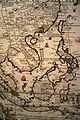
 081 franzosisch-indochina (1905).png 1,176 × 1,718; 1.41 MB
-

-
 Indo-chine française - par P. Vidal-Lablache... - btv1b525141135 (2 of 2).jpg 16,098 × 18,177; 62.56 MB
-
 1899 Map of Tonkin.jpg 8,864 × 9,000; 9.49 MB
-
 1899 Map of Tonkin.png 8,864 × 9,000; 76.28 MB
-
 1925 Air Routes in Indochina.jpg 1,233 × 1,572; 423 KB
-
 28 of 'The Peoples and Politics of the Far East, etc' (11231870083).jpg 2,320 × 1,488; 741 KB
-

-
 454 of 'La France et les Colonies. (Illustrated.)' (11189523204).jpg 2,066 × 2,751; 1.34 MB
-
 Abornement frontière Fromentin embouchure 05114.jpg 4,912 × 3,264; 4.4 MB
-
 Anh-bac-ninh.jpg 2,279 × 3,038; 746 KB
-
 Anhthaibinh.jpg 640 × 525; 154 KB
-
 Annam - btv1b8439722p.jpg 4,256 × 6,727; 3.45 MB
-

-
 Annam et Tonkin (Nouvelle édition) - btv1b53022705d.jpg 5,795 × 7,337; 6.04 MB
-
 Annam et Tonkin - btv1b530212322.jpg 6,861 × 8,933; 8.15 MB
-
 Annam, Cochinchine et Tonkin - btv1b8439237d.jpg 5,600 × 7,810; 5.93 MB
-
 Asia (late 19th century- early 20th century).jpg 1,857 × 1,387; 773 KB
-
 Asia 1932.jpg 8,315 × 9,984; 12.4 MB
-

-
-

-

-
 Ban-do-hanh-chinh-tinh-Ha-Nam-S189.jpg 2,812 × 2,514; 2.23 MB
-
 Bán đảo đông dương 1950.png 3,142 × 4,754; 631 KB
-
 Ca. 1925 French map of Southern Vietnam.jpg 20,251 × 16,291; 32.84 MB
-
 Cambodge et Siam 1880 05122.JPG 4,912 × 3,264; 4.56 MB
-
 Cambodia indochina map 1886.jpg 758 × 529; 197 KB
-

-
 Carte au Tonkin - dressé... par Henri Mager - btv1b84456068.jpg 5,288 × 6,810; 5.16 MB
-
 Carte de l'Indo-Chine. 4, Annam. Flle. N° 4 - btv1b53027634j.jpg 10,975 × 8,125; 17.09 MB
-
 Carte de l'état du résean routior du Sud Annam - btv1b53195614g.jpg 8,016 × 10,788; 6.15 MB
-

-
 Carte de la Presqu'île indochinoise - btv1b53195583j.jpg 8,176 × 9,680; 7.5 MB
-
 Carte des opérations de 1885 5218.jpg 3,154 × 2,865; 1.96 MB
-
 Carte des routes du Tonkin et du Nord-Annam accessibles aux automobiles - btv1b53212199w.jpg 13,107 × 13,671; 17.7 MB
-

-

-

-

-

-

-

-

-

-

-

-

-
 Carte du Tonkin et de la Cochinchine - btv1b8444647w.jpg 6,320 × 9,132; 9.79 MB
-
 Carte du Tonkin et de la Cochinchine - gravée par L. Sonnet - btv1b8446415v.jpg 5,363 × 8,173; 8.67 MB
-
 Carte du Tonkin et de la Cochinchine française - gravée par L. Sonnet - btv1b8446065c.jpg 4,944 × 7,631; 7.23 MB
-
 Carte générale de l'Indochine française - btv1b531671021.jpg 8,976 × 12,300; 12.72 MB
-
 Carte politique de l'Indo-Chine (...)Deloncle François btv1b53025089w.jpg 1,024 × 1,548; 413 KB
-

-

-
 Carte économique de l'Indochine - btv1b53121256z.jpg 7,756 × 10,884; 10.41 MB
-
 Cartes de l'Indo-Chine - Annam, Tonkin, Cochinchine - btv1b531670607.jpg 11,170 × 8,452; 14.7 MB
-
 Cartes routières de la Cochinchine - dressée par le Service des Travaux publics - btv1b531670948.jpg 15,048 × 14,096; 16.45 MB
-

-
 China 1910.jpg 2,208 × 1,689; 1.38 MB
-
 Chinese South Sea.jpg 3,961 × 4,549; 6.06 MB
-
 Cochinch-tonkin.JPG 1,401 × 2,371; 947 KB
-
 Cochinchine et Tonkin - carte de l'Indochine - btv1b530814228.jpg 4,362 × 5,474; 4.15 MB
-

-
 Collier's 1921 Burma - map of Burma, Siam, French Indo-China and Straits Settlements.jpg 1,900 × 2,365; 1.49 MB
-
 Colonial Boundaries in Southeast Asia.jpg 1,229 × 898; 220 KB
-

-
 Dissident Activities in Indochina.svg 754 × 1,140; 392 KB
-

-
 EB1911 Indo-China, French.jpg 1,769 × 2,527; 1.69 MB
-
 Francouzská Indočína.jpg 1,784 × 2,715; 1.54 MB
-
 French Indochina (1945).svg 538 × 536; 511 KB
-
 French Indochina 1900-1945 location map.svg 703 × 1,013; 1.92 MB
-
 French Indochina 1900-1945 relief location map.svg 703 × 1,013; 4.2 MB
-
 French Indochina 1900-1945-fr.svg 703 × 1,013; 1.75 MB
-
 French Indochina 1900-1946-es.svg 703 × 1,013; 683 KB
-
 French Indochina 1937.png 1,292 × 2,000; 515 KB
-
 French Indochina c. 1930.jpg 447 × 659; 107 KB
-
 French Indochina expansion.jpg 596 × 1,019; 215 KB
-
 French Indochina locator.svg 250 × 120; 166 KB
-
 French indochina map.png 1,000 × 1,000; 297 KB
-
 French Indochina Phan Xich Long no.svg 667 × 1,017; 77 KB
-
 French Indochina Phan Xich Long.svg 667 × 1,017; 77 KB
-
 French Indochina post partition.png 300 × 457; 15 KB
-
 French Indochina subdivisions Ce.svg 667 × 1,017; 143 KB
-
 French Indochina subdivisions Ru.svg 667 × 1,017; 154 KB
-
 French Indochina subdivisions sr.svg 667 × 1,017; 151 KB
-
 French Indochina subdivisions ww2-es.svg 667 × 1,017; 547 KB
-
 French Indochina subdivisions ww2.svg 667 × 1,017; 81 KB
-
 French Indochina subdivisions-es.svg 667 × 1,017; 374 KB
-
 French Indochina subdivisions.svg 667 × 1,017; 150 KB
-
 French indochina.svg 667 × 1,017; 113 KB
-

-

-
 Indo-Chine française - de Lanessan ; Erhard frères - btv1b84397233.jpg 3,779 × 5,309; 2.83 MB
-
 Flag Map of French Indochina (1887 - 1954).png 1,855 × 2,946; 49 KB
-
 Indochina 1954.jpg 701 × 845; 175 KB
-
 Indochina and Thailand. Special strategic map - btv1b53189306w.jpg 7,436 × 8,626; 9.42 MB
-
 Flag map of French Indochina (France).png 2,000 × 3,049; 57 KB
-
 Indochine - btv1b53065045p.jpg 10,836 × 14,173; 22.36 MB
-
 Indochine - btv1b530650803.jpg 7,616 × 9,976; 10.25 MB
-
 Indochine - btv1b530668524.jpg 10,598 × 13,579; 19.26 MB
-
 Indochine - btv1b53066856x.jpg 7,535 × 9,916; 9 MB
-
 Indochine - Cochinchine. Cambodge. Annam. Bas-Laos - btv1b53192640w.jpg 9,602 × 8,562; 13.56 MB
-

-
 Indochine Francaise 1937.png 1,292 × 2,000; 516 KB
-
 Indochine francaise de.svg 667 × 1,017; 41 KB
-
 Indochine francaise.svg 667 × 1,017; 113 KB
-
 Indochine française (1913).jpg 500 × 827; 80 KB
-
 Indochine française ce.svg 667 × 1,017; 87 KB
-
 Indochine française es.svg 667 × 1,017; 100 KB
-
 Indochine française ru.svg 667 × 1,017; 102 KB
-
 Indochine française.svg 667 × 1,017; 101 KB
-

-

-

-
 L.Girod-Dix Ans de Haut-Tonkin-1899-carte de la Mission du Haut-Tonkin.jpg 2,000 × 2,658; 4.28 MB
-
 Landing Fields - Franch Indo China - - NARA - 68159405 (page 1).jpg 5,301 × 6,865; 5.11 MB
-
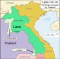 Laos 1941-46.png 1,003 × 996; 162 KB
-
 Le Tour du monde-01-p061.jpg 826 × 1,234; 262 KB
-
 LocalisationIndochine.png 247 × 154; 6 KB
-
 Location Guangzhou Wan.png 250 × 115; 6 KB
-
 Location of Bolaven Plateau on Indochina topographic map.png 1,687 × 2,436; 4 MB
-
 Locationfrenchindochina.PNG 250 × 115; 5 KB
-
 LocationFrenchIndochina.svg 1,000 × 500; 807 KB
-

-
 Map of French Indochina expansion.svg 675 × 970; 733 KB
-
 Map of Siam (territorial cessions).svg 656 × 1,243; 760 KB
-
 Map of Siam and French Indochina -by Milenioscuro- (modified Thai language).png 1,039 × 1,726; 586 KB
-
 Map of Siam and French Indochina.svg 748 × 1,243; 1,014 KB
-
 Map of the French protectorate of Annam.jpg 1,734 × 3,265; 2.24 MB
-

-

-

-

-

-

-

-

-

-
 Map of the Rattanakosin Kingdom.svg 656 × 1,243; 686 KB
-
 Map of Tibet in 1932 (cropped).jpg 2,676 × 1,687; 1.86 MB
-

-
 Mithoi expédition 05039.jpg 1,659 × 4,664; 1.91 MB
-
 Nguyễn Dynasty, administrative divisions map (1937).svg 1,086 × 1,100; 1.7 MB
-
 OldFrenchIndoChina 1870.jpg 1,000 × 1,270; 440 KB
-
 PacificTheaterAug1942.jpg 1,199 × 873; 256 KB
-
 Philipine Cambodge 1696 Nicolas de Fer 04984.jpg 3,264 × 4,912; 5.08 MB
-
-
 Plan de Son Tay.jpg 776 × 626; 191 KB
-
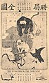 Political Map of 19th Century China(時局全圖).jpg 580 × 974; 259 KB
-
 Poste militaires du Tonkin et des pirates 05286.jpg 3,774 × 2,821; 2.65 MB
-
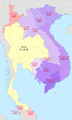
 Provinces of Cambodia loss to Thailand during Franco-Thai War Km.png 1,200 × 900; 4.14 MB
-
 Provinces of Cambodia loss to Thailand during Franco-Thai War.png 1,200 × 900; 187 KB
-
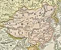 Qing china.jpg 888 × 725; 779 KB
-
 RC4 vietnam-es.svg 703 × 1,013; 919 KB
-
 RC4 vietnam.jpg 277 × 598; 23 KB
-
 Route of the French Mekong Expedition 1866-1868.jpg 2,299 × 2,347; 2.4 MB
-
 Siamese territorial concessions (1867-1909) with flags.gif 301 × 514; 32 KB
-
 Siamese territorial concessions (1867-1909).gif 301 × 514; 36 KB
-
 Simple map of French Indochina in Japanese 1941.jpg 864 × 1,315; 182 KB
-
 SuddivisioniIndocinafrancese.png 800 × 1,220; 171 KB
-
 Thailand and French Indochina ethnic groups - OSS - btv1b53196956h.jpg 7,742 × 8,658; 8.9 MB
-
 Thailand and French Indochina territorial retrocessions 1941 - OSS - btv1b53196958d.jpg 7,696 × 8,664; 9.08 MB
-
 The situation in the Far East by Tse Tsan-tai.jpg 1,245 × 1,794; 505 KB
-

-
 Tinh-vinh-yen.jpg 2,448 × 3,264; 1.47 MB
-
 Tonkin et Nord-Annam - dressée par la Direction des Affaires Economiques - btv1b532121970.jpg 12,291 × 9,214; 16.3 MB
-

-

-
 Wyld's Map of Tong-King and Annam - btv1b53023137m.jpg 6,731 × 8,868; 9.03 MB
-
 Французский Вьетнам.png 330 × 713; 55 KB
-
 时局图.jpg 3,915 × 5,532; 4.27 MB
-
 暹罗的领土丧失(1867-1909).png 300 × 730; 99 KB
-
 프랑스령 인도차이나 반도.png 1,024 × 1,020; 269 KB
-
 프랑스령 인도차이나 지도.jpg 1,024 × 1,020; 167 KB

.png)
.png)
.jpg)


.jpg)
.jpg)
%27_(11189523204).jpg)


_-_btv1b53022705d.jpg)


.jpg)

.jpg)
.jpg)
.jpg)
.jpg)


.jpg)
.jpg)
.jpg)
.jpg)
.jpg)
.jpg)
.jpg)
.jpg)
.jpg)
.jpg)
.jpg)


Deloncle_Fran%C3%A7ois_btv1b53025089w.jpg)

_jointe_au_rapport_n%C2%B0_77_en_date_du_7_octobre_1905,_concernant_une_%C3%A9tude_ethnologique_de_la_province._Le_R%C3%A9sident._Valentin_-_btv1b53195561t.jpg)


.jpg)


.png)


.png)


.jpg)


_-_Fort_Bayard_-_P%C3%A9ninsule_de_Leizhou.png)

.jpg)


.jpg)

.svg)
.png)


.png)
.png)
.png)
.png)
.png)
.png)
.png)
.png)
.png)

.jpg)
.svg)


_with_flags.gif)
.gif)


_(14777858222)_(cropped).jpg)


%27_(11097900285).jpg)