Category:Maps of Dorchester, Boston
Jump to navigation
Jump to search
Wikimedia category | |||||
| Upload media | |||||
| Instance of | |||||
|---|---|---|---|---|---|
| Category combines topics | |||||
| Dorchester | |||||
neighborhood in Boston, Massachusetts   | |||||
| Instance of | |||||
| Location | Boston, Suffolk County, Massachusetts | ||||
| Inception |
| ||||
| official website | |||||
 | |||||
Subcategories
This category has only the following subcategory.
Media in category "Maps of Dorchester, Boston"
The following 56 files are in this category, out of 56 total.
-
 1850 map Dorchester Massachusetts by Whiting BPL 11129.png 920 × 724; 740 KB
-
 1884 topographical map of West Roxbury Park.jpg 10,224 × 7,214; 7.85 MB
-
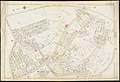
 1893 OaklandGarden Boston map bySampson Murdock BPL 12466 detail.png 1,064 × 746; 1.34 MB
-
 2012 District 3 Boston City Council electoral districts map.jpg 607 × 698; 571 KB
-

-
 Atlas of the city of Boston - Dorchester, Mass - (title page) (19891708621).jpg 2,000 × 1,371; 2.47 MB
-
 Atlas of the city of Boston - Dorchester, Mass - plate 1 (19698697500).jpg 2,000 × 1,362; 2.92 MB
-
 Atlas of the city of Boston - Dorchester, Mass - plate 10 (19264049864).jpg 2,000 × 1,357; 2.73 MB
-
 Atlas of the city of Boston - Dorchester, Mass - plate 11 (19886716775).jpg 2,000 × 1,361; 2.22 MB
-
 Atlas of the city of Boston - Dorchester, Mass - plate 12 (19879234072).jpg 2,000 × 1,359; 2.55 MB
-
 Atlas of the city of Boston - Dorchester, Mass - plate 13 (19698700930).jpg 2,000 × 1,358; 2.37 MB
-
 Atlas of the city of Boston - Dorchester, Mass - plate 14 (19698677248).jpg 2,000 × 1,364; 2.42 MB
-
 Atlas of the city of Boston - Dorchester, Mass - plate 15 (19265772073).jpg 2,000 × 1,364; 2.55 MB
-
 Atlas of the city of Boston - Dorchester, Mass - plate 16 (19879235542).jpg 2,000 × 1,366; 2.68 MB
-
 Atlas of the city of Boston - Dorchester, Mass - plate 17 (19698678498).jpg 2,000 × 1,368; 2.49 MB
-
 Atlas of the city of Boston - Dorchester, Mass - plate 18 (19700050439).jpg 2,000 × 1,360; 2.5 MB
-
 Atlas of the city of Boston - Dorchester, Mass - plate 19 (19264052904).jpg 2,000 × 1,363; 2.4 MB
-
 Atlas of the city of Boston - Dorchester, Mass - plate 2 (19700045669).jpg 2,000 × 1,358; 2.75 MB
-
 Atlas of the city of Boston - Dorchester, Mass - plate 20 (19698703440).jpg 2,000 × 1,370; 2.4 MB
-
 Atlas of the city of Boston - Dorchester, Mass - plate 21 (19891715371).jpg 2,000 × 1,364; 2.25 MB
-
 Atlas of the city of Boston - Dorchester, Mass - plate 22 (19264053734).jpg 2,000 × 1,362; 2.53 MB
-
 Atlas of the city of Boston - Dorchester, Mass - plate 23 (19698679958).jpg 2,000 × 1,366; 2.55 MB
-
 Atlas of the city of Boston - Dorchester, Mass - plate 24 (19891716121).jpg 2,000 × 1,364; 2.53 MB
-
 Atlas of the city of Boston - Dorchester, Mass - plate 25 (19700052369).jpg 2,000 × 1,364; 2.38 MB
-
 Atlas of the city of Boston - Dorchester, Mass - plate 26 (19698680778).jpg 2,000 × 1,367; 2.5 MB
-
 Atlas of the city of Boston - Dorchester, Mass - plate 27 (19860484966).jpg 2,000 × 1,370; 2.61 MB
-
 Atlas of the city of Boston - Dorchester, Mass - plate 28 (19264055274).jpg 2,000 × 1,361; 2.46 MB
-
 Atlas of the city of Boston - Dorchester, Mass - plate 29 (19891717131).jpg 2,000 × 1,367; 2.25 MB
-
 Atlas of the city of Boston - Dorchester, Mass - plate 3 (19879231642).jpg 2,000 × 1,352; 2.55 MB
-
 Atlas of the city of Boston - Dorchester, Mass - plate 30 (19698681908).jpg 2,000 × 1,366; 2.31 MB
-
 Atlas of the city of Boston - Dorchester, Mass - plate 31 (19860486096).jpg 2,000 × 1,366; 2.48 MB
-
 Atlas of the city of Boston - Dorchester, Mass - plate 32 (19265776323).jpg 2,000 × 1,369; 2.47 MB
-
 Atlas of the city of Boston - Dorchester, Mass - plate 33 (19698682878).jpg 2,000 × 1,366; 2.52 MB
-
 Atlas of the city of Boston - Dorchester, Mass - plate 34 (19700054549).jpg 2,000 × 1,367; 2.41 MB
-
 Atlas of the city of Boston - Dorchester, Mass - plate 35 (19879240442).jpg 2,000 × 1,367; 2.55 MB
-
 Atlas of the city of Boston - Dorchester, Mass - plate 36 (19700055129).jpg 2,000 × 1,372; 2.18 MB
-
 Atlas of the city of Boston - Dorchester, Mass - plate 37 (19886723755).jpg 2,000 × 1,366; 2.39 MB
-
 Atlas of the city of Boston - Dorchester, Mass - plate 38 (19265777773).jpg 2,000 × 1,379; 2.64 MB
-
 Atlas of the city of Boston - Dorchester, Mass - plate 39 (19879241362).jpg 2,000 × 1,367; 2.16 MB
-
 Atlas of the city of Boston - Dorchester, Mass - plate 4 (19265768793).jpg 2,000 × 1,359; 2.47 MB
-
 Atlas of the city of Boston - Dorchester, Mass - plate 5 (19879232132).jpg 2,000 × 1,357; 2.74 MB
-
 Atlas of the city of Boston - Dorchester, Mass - plate 6 (19879232402).jpg 2,000 × 1,359; 2.77 MB
-
 Atlas of the city of Boston - Dorchester, Mass - plate 7 (19265769893).jpg 2,000 × 1,357; 2.68 MB
-
 Atlas of the city of Boston - Dorchester, Mass - plate 8 (19265770003).jpg 2,000 × 1,364; 2.59 MB
-
 Atlas of the city of Boston - Dorchester, Mass - plate 9 (19860479616).jpg 2,000 × 1,355; 2.44 MB
-
 Dorchester 1858.jpg 682 × 642; 391 KB
-
 Dorchester MA Neighborhoods 2020.png 440 × 660; 82 KB
-
 Dorchester MA Neighborhoods June2020 Update South Bay.png 440 × 660; 95 KB
-
 Dorchester MA Neighborhoods.png 440 × 660; 96 KB
-
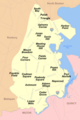 Dorchester, MA Neighborhoods June 2020 Update.png 440 × 660; 95 KB
-
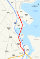 Morrissey Boulevard.png 1,780 × 2,639; 667 KB
-
 Plan of Dorchester (2674667143).jpg 2,000 × 1,551; 2 MB
-
 Plan of house lots for sale on Savin Hill Avenue, Dorchester, Mass. (2675504956).jpg 2,000 × 1,521; 1.65 MB
-
 Plan of land owned by the heirs of Frederick Clapp (2675509994).jpg 2,000 × 1,269; 1.96 MB
-
 Plan of lots on West Selden Street, Dorchester (2675506802).jpg 2,000 × 533; 833 KB
-
 Plan of real estate belonging to T.W. & J.H. Cox (2675506334).jpg 2,000 × 1,309; 1.58 MB


.jpg)
_(19891708621).jpg)
.jpg)
.jpg)
.jpg)
.jpg)
.jpg)
.jpg)
.jpg)
.jpg)
.jpg)
.jpg)
.jpg)
.jpg)
.jpg)
.jpg)
.jpg)
.jpg)
.jpg)
.jpg)
.jpg)
.jpg)
.jpg)
.jpg)
.jpg)
.jpg)
.jpg)
.jpg)
.jpg)
.jpg)
.jpg)
.jpg)
.jpg)
.jpg)
.jpg)
.jpg)
.jpg)
.jpg)
.jpg)
.jpg)
.jpg)


.jpg)
.jpg)
.jpg)
.jpg)
.jpg)