Category:Maps of Columbus County, North Carolina
Jump to navigation
Jump to search
Counties of North Carolina: Alamance · Alexander · Alleghany · Anson · Ashe · Avery · Beaufort · Bertie · Bladen · Brunswick · Buncombe · Burke · Cabarrus · Caldwell · Camden · Carteret · Caswell · Catawba · Chatham · Cherokee · Chowan · Clay · Cleveland · Columbus · Craven · Cumberland · Currituck · Dare · Davidson · Davie · Duplin · Durham · Edgecombe · Forsyth · Franklin · Gaston · Gates · Graham · Granville · Greene · Guilford · Halifax · Harnett · Haywood · Henderson · Hertford · Hoke · Hyde · Iredell · Jackson · Johnston · Jones · Lee · Lenoir · Lincoln · Macon · Madison · Martin · McDowell · Mecklenburg · Mitchell · Montgomery · Moore · Nash · New Hanover · Northampton · Onslow · Orange · Pamlico · Pasquotank · Pender · Perquimans · Person · Pitt · Polk · Randolph · Richmond · Robeson · Rockingham · Rowan · Rutherford · Sampson · Scotland · Stanly · Stokes · Surry · Swain · Transylvania · Tyrrell · Union · Vance · Wake · Warren · Washington · Watauga · Wayne · Wilkes · Wilson · Yadkin · Yancey
Wikimedia category | |||||
| Upload media | |||||
| Instance of | |||||
|---|---|---|---|---|---|
| Category combines topics | |||||
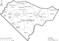
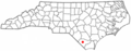
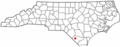
| Columbus County | |||||
county in North Carolina, United States   | |||||
| Instance of | |||||
| Named after | |||||
| Location | North Carolina | ||||
| Capital | |||||
| Inception |
| ||||
| Population |
| ||||
| Area |
| ||||
| Different from | |||||
| official website | |||||
 | |||||
Columbus County is located in North Carolina in the United States. Its county seat is Whiteville.
Media in category "Maps of Columbus County, North Carolina"
The following 13 files are in this category, out of 13 total.
-
-
 Map of North Carolina highlighting Columbus County.svg 8,061 × 3,056; 236 KB
-
 NCMap-doton-Boardman.PNG 300 × 117; 9 KB
-
 NCMap-doton-Bolton.PNG 300 × 117; 9 KB
-
 NCMap-doton-Brunswick.PNG 300 × 117; 9 KB
-
 NCMap-doton-CerroGordo.PNG 300 × 117; 9 KB
-
 NCMap-doton-Chadbourn.PNG 300 × 117; 9 KB
-
 NCMap-doton-FairBluff.PNG 300 × 117; 9 KB
-
 NCMap-doton-LakeWaccamaw.PNG 300 × 117; 9 KB
-
 NCMap-doton-Sandyfield.PNG 300 × 117; 9 KB
-
 NCMap-doton-TaborCity.PNG 300 × 117; 9 KB
-
 NCMap-doton-Whiteville.PNG 300 × 117; 9 KB
-
 North Carolina Map Highlighting Columbus County.PNG 531 × 201; 15 KB
