Category:Maps of Chanteau
Jump to navigation
Jump to search
Wikimedia category | |||||
| Upload media | |||||
| Instance of | |||||
|---|---|---|---|---|---|
| Category combines topics | |||||
| Chanteau | |||||
commune in Loiret, France  .svg)  | |||||
| Instance of | |||||
| Location |
| ||||
| Population |
| ||||
| Area |
| ||||
| official website | |||||
 | |||||
Subcategories
This category has only the following subcategory.
G
- Geological maps of Chanteau (8 F)
Media in category "Maps of Chanteau"
The following 13 files are in this category, out of 13 total.
-
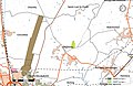 45 Znieff 68.jpg 5,457 × 3,543; 1.19 MB
-
 45-Chanteau-Routes.png 5,457 × 3,543; 2.33 MB
-
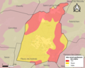 45072-Chanteau-argile.png 3,057 × 2,480; 2.3 MB
-
 45072-Chanteau-Arron.png 7,015 × 4,960; 3.96 MB
-
 45072-Chanteau-Canton.png 7,015 × 4,960; 4.02 MB
-
 45072-Chanteau-Cours eau.jpg 3,507 × 2,480; 366 KB
-
 45072-Chanteau-EPCI.png 7,015 × 4,960; 4 MB
-
 45072-Chanteau-Hydro.jpeg 5,846 × 4,133; 1.92 MB
-
 45072-Chanteau-Orthophoto.jpeg 10,559 × 7,440; 15.56 MB
-
 45072-Chanteau-Sols.png 3,519 × 2,480; 1.78 MB
-
 Chanteau-Interco.png 3,507 × 2,480; 1.14 MB
-
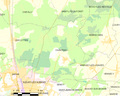 Map commune FR insee code 45072.png 756 × 605; 65 KB
-
 Orléans-Métropole-déchets-Chanteau.png 5,457 × 3,589; 1.5 MB


