Category:Maps of Cairo, Illinois
Jump to navigation
Jump to search
Subcategories
This category has only the following subcategory.
Media in category "Maps of Cairo, Illinois"
The following 9 files are in this category, out of 9 total.
-
 1861 Cairo detail of H.H. Lloyd & Co's Military Charts USA by Viele BPL 14829.png 1,062 × 750; 1.38 MB
-

-
 Cairo illinois 1888 panoramic.jpg 4,000 × 2,570; 1.25 MB
-
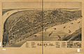
 CairoIllPerspectiveMap1885.jpg 1,027 × 591; 150 KB
-
 Map highlighting Cairo, Alexander County, Illinois.svg 512 × 512; 58 KB
-
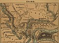
 Map of Cairo and its Vicinity.jpg 396 × 444; 37 KB
-
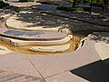 River Walk P9140355.JPG 640 × 480; 58 KB
-
 US 60-62 (IL) map.svg 1,180 × 688; 191 KB
-


_map.svg)
.jpg)