Category:Maps of Bundesautobahn 5
Jump to navigation
Jump to search
Wikimedia category | |||||
| Upload media | |||||
| Instance of | |||||
|---|---|---|---|---|---|
| Category combines topics | |||||
| Bundesautobahn 5 | |||||
federal motorway in Germany    | |||||
| Instance of | |||||
| Part of | |||||
| Location |
| ||||
| Transport network | |||||
| Connects with | |||||
| Owned by | |||||
| Maintained by | |||||
| Length |
| ||||
 | |||||
Media in category "Maps of Bundesautobahn 5"
The following 27 files are in this category, out of 27 total.
-
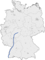 Bundesautobahn 5 map.png 1,122 × 1,515; 80 KB
-
 Map D A5 in 1976 planning.svg 1,073 × 1,272; 574 KB
-
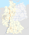
 Map D A5.svg 1,073 × 1,272; 467 KB
-
 Autobahndreieck Weil am Rhein.png 1,200 × 773; 533 KB
-
 Bad Homburger Kreuz.jpg 479 × 480; 128 KB
-
 Darmstaedter Kreuz.jpg 459 × 459; 131 KB
-
 Dreieck Darmstadt.jpg 294 × 294; 49 KB
-
 AK Frankfurter Kreuz map.tiff 821 × 615; 749 KB
-
 AK-Frankfurter Kreuz, DTV.PNG 1,200 × 1,200; 122 KB
-
 AK-Frankfurter Kreuz.png 1,200 × 1,200; 113 KB
-
 Frankfurter Kreuz.png 1,445 × 1,838; 1.16 MB
-
 Nordwestkreuz Frankfurt.jpg 490 × 491; 172 KB
-
 Westkreuz Frankfurt.jpg 462 × 462; 161 KB
-
 Anschlussstelle Freiburg-Mitte.svg 1,063 × 1,063; 2.33 MB
-
 AK Gambacher Kreuz map.tiff 817 × 613; 570 KB
-
 GambacherKreuz.PNG 822 × 600; 266 KB
-
 Gambacher Kreuz.jpg 444 × 446; 109 KB
-
 Hattenbacher Dreieck.jpg 453 × 454; 68 KB
-
 AK Heidelberg map.png 819 × 614; 729 KB
-
 AD Karlsruhe map.png 817 × 612; 619 KB
-
 Autobahndreieck Karlsruhe der A8 mit der A5.png 1,520 × 1,136; 674 KB
-
 Autobahndreieck Neuenburg der deutschen A5 mit der französischen A36.png 1,520 × 1,103; 386 KB
-
 Map AD Neuenburg.svg 1,133 × 925; 552 KB
-
 Reiskirchener Dreieck.jpg 395 × 396; 77 KB
-
 AK Walldorf map.png 819 × 614; 437 KB
-
 Autobahndreieck Weil am Rhein der A98 und der A5.png 1,520 × 1,136; 544 KB
-
 AK Weinheim map.png 817 × 613; 577 KB


