Category:Maps of Biafra
Jump to navigation
Jump to search
Wikimedia category | |||||
| Upload media | |||||
| Instance of | |||||
|---|---|---|---|---|---|
| Category combines topics | |||||
| Biafra | |||||
secessionist state in Nigeria    | |||||
| Instance of |
| ||||
| Capital | |||||
| Basic form of government | |||||
| Official language | |||||
| Anthem |
| ||||
| Currency |
| ||||
| Inception |
| ||||
| Dissolved, abolished or demolished date |
| ||||
| Population |
| ||||
| Area |
| ||||
 | |||||
Media in category "Maps of Biafra"
The following 24 files are in this category, out of 24 total.
-
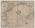 A chart of ye. coast of Biaffra - btv1b53168614k.jpg 6,535 × 5,361; 6.08 MB
-

-
 Approximate map of the Bakassi Conflict.png 1,053 × 961; 243 KB
-
 Benin (1970).png 2,000 × 2,000; 593 KB
-
 Benin Republic in its region (1967).svg 361 × 231; 251 KB
-
 Biafra in its region.svg 361 × 231; 254 KB
-
 Biafra independent state map-ar.svg 1,100 × 850; 663 KB
-
 Biafra independent state map-de.svg 1,100 × 850; 455 KB
-
 Biafra independent state map-en.svg 1,100 × 850; 472 KB
-
 Biafra independent state map-es.svg 1,100 × 850; 456 KB
-
 Biafra independent state map-fr.svg 1,100 × 850; 445 KB
-
 Biafra independent state map-it.svg 1,100 × 850; 455 KB
-
 Biafra independent state map-jp.svg 1,100 × 850; 80 KB
-
 Biafra independent state map-mk.svg 1,100 × 850; 454 KB
-
 Biafra independent state map-ru.svg 1,100 × 850; 455 KB
-
 Biafra independent state satelite.png 1,616 × 1,207; 2.37 MB
-
 Biafra map.PNG 417 × 237; 6 KB
-
 Biafra map.png 2,000 × 2,000; 516 KB
-
 Biafra sat.png 1,097 × 944; 825 KB
-
 LocationBiafra.PNG 250 × 115; 6 KB
-
 LocationRepofBenin.PNG 250 × 115; 6 KB
-
 MIdwest Invasion of 1967 map.svg 512 × 291; 34 KB
-
 Nigèria - Guèrra de Biafra.png 1,099 × 533; 340 KB
-


.png)
.svg)


.jpg)