Category:Maps of Baffin Bay
Jump to navigation
Jump to search
Wikimedia category | |||||
| Upload media | |||||
| Instance of | |||||
|---|---|---|---|---|---|
| Category combines topics | |||||
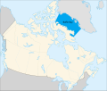
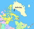
| Baffin Bay | |||||
bay between Denmark and Canada  | |||||
| Instance of | |||||
| Part of | |||||
| Named after | |||||
| Location | |||||
| Has part(s) | |||||
| Width |
| ||||
| Area |
| ||||
| Inflows |
| ||||
| Drainage basin | |||||
| Different from | |||||
 | |||||
Media in category "Maps of Baffin Bay"
The following 33 files are in this category, out of 33 total.
-
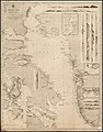
 1598 map of the Polar Regions by Willem Barentsz.jpg 13,719 × 10,160; 30.66 MB
-

-

-

-
 Admiralty Chart No 2118 Discoveries in the Arctic bk103wt7572, Published 1852, Additions to 1856.jpg 25,495 × 17,498; 56.15 MB
-
 Admiralty Chart No 2177 Arctic Sea - Baffin Bay, sheet 1 - 1853, with corrections to 1881.tiff 7,878 × 10,111; 75.97 MB
-
-
 Baffin Bay map-fr.svg 840 × 623; 108 KB
-
 Baffin Bay map-hu.svg 840 × 623; 43 KB
-
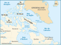
 Baffin Bay, Canada uk.png 2,000 × 1,697; 552 KB
-
 Baffin Bay, Canada-ar.svg 1,156 × 981; 77 KB
-
 Baffin Bay, Canada-et.svg 1,084 × 920; 64 KB
-
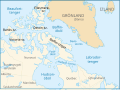
 Baffin Bay, Canada.svg 1,084 × 920; 54 KB
-
 Baffinbaai.PNG 756 × 512; 21 KB
-
 Barents third voyage.jpg 2,000 × 1,511; 965 KB
-
 Barentskartet, 1598 (12068020364).jpg 2,842 × 2,091; 3.85 MB
-
 Barentsz Full Map.jpg 1,000 × 742; 258 KB
-
 Chart C-13.jpg 8,493 × 5,422; 20.9 MB
-
 Expédition anglaise dans la mer de Baffin (33746956694).jpg 3,429 × 6,075; 11.51 MB
-
 Forminsket utgave av Barentskartet - no-nb krt 00487.jpg 4,418 × 3,449; 3.45 MB
-
 Hybrid image of Baffin Island from space.jpg 643 × 636; 166 KB
-

-

-
 Map indicating Baffin Bay-ar.png 566 × 487; 388 KB
-
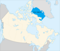
 Map indicating Baffin Bay.png 425 × 365; 68 KB
-
 Markham Davis Strait map.jpg 2,372 × 2,559; 916 KB
-
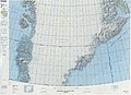
 Operational Navigation Chart B-8, 3rd edition.jpg 9,254 × 6,634; 14.14 MB
-
 Operational Navigation Chart C-12, 4th edition.jpg 9,254 × 6,705; 17.03 MB
-
 Operational Navigation Chart C-13, 3rd edition.jpg 9,254 × 6,716; 15.77 MB
-
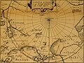 Pontanus 1611 Arctic Map.jpg 2,852 × 2,142; 802 KB
-
 Sketchmap-greenland-appat-island.svg 300 × 270; 37 KB
-
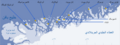 Upernavik-archipelago-baffin-bay-AR.png 2,000 × 757; 203 KB
-
 Upernavik-archipelago-baffin-bay.svg 700 × 265; 78 KB

.jpg)
.jpg)
.jpg)


.jpg)


.jpg)


_door_Willem_Barendsz_(titel_op_object),_NG-800.jpg)


