Category:Maps of Alexandria, Virginia
Jump to navigation
Jump to search
Wikimedia category | |||||
| Upload media | |||||
| Instance of | |||||
|---|---|---|---|---|---|
| Category combines topics | |||||
| Alexandria | |||||
city in the state of Virginia, United States     | |||||
| Instance of |
| ||||
| Part of |
| ||||
| Named after |
| ||||
| Location |
| ||||
| Located in or next to body of water | |||||
| Official language | |||||
| Head of government |
| ||||
| Inception |
| ||||
| Population |
| ||||
| Area |
| ||||
| Elevation above sea level |
| ||||
| Different from | |||||
| official website | |||||
 | |||||
Subcategories
This category has the following 2 subcategories, out of 2 total.
Media in category "Maps of Alexandria, Virginia"
The following 33 files are in this category, out of 33 total.
-
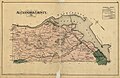 1878 Alexandria County Virginia.jpg 7,504 × 4,896; 5.46 MB
-
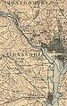 1894 washington dc1894.jpg 694 × 1,102; 398 KB
-
 A Plan of Alexandria now Belhaven.jpg 640 × 513; 63 KB
-
 Alexandria Bird's Eye View 1863.jpg 7,624 × 5,112; 23.5 MB
-
 Alexandria County Landowner map, 1900.jpg 12,799 × 19,433; 29.98 MB
-
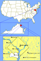 Alexandria, VA Location.png 400 × 600; 28 KB
-
 Alexandria, Virginia surrounding area.svg 875 × 541; 953 KB
-
 Alexandria, Virginia.svg 733 × 475; 574 KB
-
 Carlyle Map Alex (4908247500).jpg 1,000 × 750; 820 KB
-
 Dyke Marsh map.JPG 598 × 520; 98 KB
-
 Fort-lyon-alexandria-virginia-vhs00032-1-.jpg 1,609 × 2,158; 1.17 MB
-
 Forts-near-Alexandria-VA-vhs0011.jpg 1,786 × 2,214; 777 KB
-
 King Street.png 512 × 338; 193 KB
-
 Location map Alexandra Historic District, Virginia.png 750 × 726; 271 KB
-
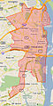
 Location map West Alexandria, Virginia.png 784 × 727; 551 KB
-
 Map of Alexandria County, Virginia showing DC Boundary Stones.png 1,406 × 1,242; 603 KB
-
 Map of the District of Columbia, 1835.jpg 2,451 × 3,226; 6.29 MB
-
 Map of Virginia highlighting Alexandria and Arlington.svg 7,486 × 3,247; 224 KB
-
 Map of Virginia highlighting Alexandria City.svg 7,486 × 3,247; 223 KB
-
 Map showing Alexandria city, Virginia.png 750 × 485; 34 KB
-
 Pitner's map of greater Washington, 1938 ce.jpg 6,209 × 8,263; 9.31 MB
-
 Plat of the land where on stands the town of Alexandria. LOC 99466767.jpg 6,686 × 5,250; 2.73 MB
-
 Plat of the land where on stands the town of Alexandria. LOC 99466767.tif 6,686 × 5,250; 100.43 MB
-

-
 Sketch of land of the Southern Railway.png 1,300 × 1,536; 304 KB
-
 USGS 1945 Alexandria Virginia alexandria 1945z.jpg 4,144 × 5,229; 2.76 MB
-
 VA District 30.jpg 226 × 450; 60 KB
-
 VAMap-doton-Alexandria.png 300 × 134; 9 KB
-
 Vicinity of Washington DC by Griffith Hopkins, 1894 (Jackson City detail crop).jpg 1,693 × 1,938; 867 KB
-
 Vicinity of Washington DC by Griffith Hopkins, 1894.jpg 18,600 × 18,600; 46.48 MB
-
 Virginia Senate District 30 (2011).png 3,507 × 1,529; 680 KB
-
 Virginia Senate District 35 (2011).png 3,504 × 1,527; 680 KB
-
 Virginia Senate District 39 (2011).png 3,504 × 1,529; 681 KB


.jpg)


.jpg)

.png)
.png)
.png)