Category:Maps of Alençon
Jump to navigation
Jump to search
Wikimedia category | |||||
| Upload media | |||||
| Instance of | |||||
|---|---|---|---|---|---|
| Category combines topics | |||||
| Alençon | |||||
commune in Orne, France    | |||||
| Instance of | |||||
| Location |
| ||||
| Located in or next to body of water | |||||
| Population |
| ||||
| Area |
| ||||
| Elevation above sea level |
| ||||
| official website | |||||
 | |||||
Subcategories
This category has the following 2 subcategories, out of 2 total.
P
U
- Urbanisation maps of Alençon (4 F)
Media in category "Maps of Alençon"
The following 13 files are in this category, out of 13 total.
-
 61-AAV2020-Alençon.png 3,519 × 2,930; 2.41 MB
-
 61-Alençon-AAV2020.png 3,519 × 2,930; 2.35 MB
-
 61001-Alençon-Hydro.jpeg 5,846 × 4,133; 3.29 MB
-
 61001-Alençon-Sols.png 3,270 × 2,598; 5.5 MB
-
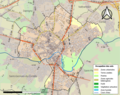
 Alençon OSM 01.png 447 × 436; 135 KB
-
 Alençon OSM 02.png 444 × 436; 228 KB
-
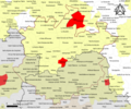
 Arrondissement d Alençon.PNG 579 × 478; 15 KB
-
-
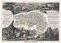
 GeneraliteAlencon1774.jpg 688 × 554; 422 KB
-
 Map commune FR insee code 61001.png 756 × 605; 56 KB
-
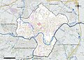
 SituationAlençon.JPG 850 × 560; 42 KB
-
 Situationalençon.svg 926 × 611; 207 KB
-
 SituationAlençon2.JPG 846 × 540; 75 KB


_-_Geographicus_-_Orne-levasseur-1852.jpg)


