Category:Maps of 4th-century BC India
Jump to navigation
Jump to search
Countries of Asia: India
Media in category "Maps of 4th-century BC India"
The following 10 files are in this category, out of 10 total.
-
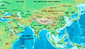 Asia 323bc.jpg 2,040 × 1,169; 733 KB
-
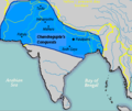 Chandragupta mauryan empire 305 BC.png 400 × 337; 18 KB
-
 EasternSatrapsAfterAlexander-es.svg 577 × 673; 40.51 MB
-
 EasternSatrapsAfterAlexander.jpg 1,119 × 1,393; 324 KB
-
 India - Empèri Gupta vèrs 400.png 445 × 570; 72 KB
-
 Magadha Expansion 1.gif 680 × 593; 2.78 MB
-
 Magadha Expansion 2.gif 680 × 593; 2.21 MB
-
 Mahabharata BharatVarsh.jpg 4,581 × 5,476; 4.05 MB
-
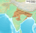 Nanda Empire, c.325 BCE.png 1,200 × 1,121; 2.12 MB
-
 தெற்காசிய வரைபடம் கி. பி. 375.svg 512 × 496; 484 KB


