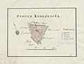
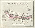
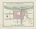
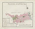
Category:Maps from Wiblingen Atlas
Jump to navigation
Jump to search
A collection of hand drawn maps of swedish towns by the cartographer Fredrik Adolf Wiblingen | |||||
| Upload media | |||||
| Instance of |
| ||||
|---|---|---|---|---|---|
| Creator | |||||
| Has part(s) |
| ||||
| Collection | |||||
| Inception |
| ||||
| |||||
Svenska: Kartbok utgiven av Fredrik Adolf Wiblingen med kartor från slutet av 1700-talet och början av 1800-talet.
Media in category "Maps from Wiblingen Atlas"
The following 149 files are in this category, out of 149 total.
-
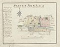 18th century map of Arboga, Sweden.jpg 3,984 × 3,107; 780 KB
-
 18th century map of Askersund.jpg 4,083 × 3,107; 757 KB
-
 18th century map of Borås.jpg 3,810 × 3,012; 654 KB
-
 18th century map of Eksjö, Sweden.jpg 3,774 × 3,320; 772 KB
-
 18th century map of Enköping, Sweden.jpg 3,750 × 3,176; 674 KB
-
 18th century map of Eskilstuna, Sweden.jpg 4,327 × 3,441; 847 KB
-
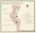
 18th century map of Falkenberg, Sweden.jpg 3,657 × 3,311; 668 KB
-
 18th century map of Falköping, Sweden.jpg 3,847 × 2,686; 557 KB
-
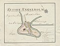
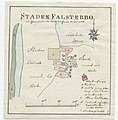 18th century map of Falsterbo, Sweden.jpg 3,224 × 3,265; 579 KB
-
 18th century map of Filipstad, Sweden.jpg 4,316 × 3,181; 713 KB
-
 18th century map of Gränna, Sweden.jpg 3,853 × 3,117; 672 KB
-
 18th century map of Gävle, Sweden.jpg 4,333 × 3,357; 1.21 MB
-
 18th century map of Halmstad, Sweden.jpg 3,976 × 3,145; 659 KB
-
 18th century map of Hedemora, Sweden.jpg 4,065 × 3,428; 821 KB
-
 18th century map of Hjo, Sweden.jpg 3,922 × 2,997; 653 KB
-
 18th century map of Hudiksvall, Sweden.jpg 3,928 × 3,081; 753 KB
-
 18th century map of Härnösand, Sweden.jpg 4,144 × 3,368; 898 KB
-
 18th century map of Jönköping, Sweden.jpg 4,415 × 2,916; 797 KB
-
 18th century map of Kalmar, Sweden.jpg 4,259 × 3,240; 905 KB
-
 18th century map of Karlshamn, Sweden.jpg 3,892 × 3,276; 841 KB
-
 18th century map of Karlstad, Sweden.jpg 4,131 × 3,119; 788 KB
-
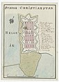 18th century map of Kristianstad, Sweden.jpg 2,916 × 4,050; 708 KB
-
 18th century map of Kristinehamn, Sweden.jpg 4,170 × 3,396; 845 KB
-
 18th century map of Kungsbacka, Sweden.jpg 4,107 × 3,121; 675 KB
-
 18th century map of Kungälv, Sweden.jpg 4,049 × 3,190; 790 KB
-
 18th century map of Köping, Sweden.jpg 4,008 × 3,417; 823 KB
-
 18th century map of Landskrona, Sweden.jpg 3,995 × 3,332; 826 KB
-
 18th century map of Lidköping, Sweden.jpg 3,959 × 3,261; 768 KB
-
 18th century map of Lindesberg, Sweden.jpg 3,960 × 3,142; 775 KB
-
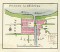
 18th century map of Linköping, Sweden.jpg 4,157 × 3,513; 847 KB
-
 18th century map of Luleå, Sweden.jpg 3,804 × 2,999; 640 KB
-
 18th century map of Lund, Sweden.jpg 4,109 × 3,361; 1.1 MB
-
 18th century map of Malmköping, Sweden.jpg 3,977 × 3,213; 720 KB
-
 18th century map of Malmö, Sweden.jpg 6,508 × 4,161; 1.84 MB
-
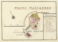
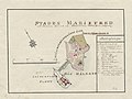 18th century map of Mariefred, Sweden.jpg 4,152 × 3,128; 733 KB
-
 18th century map of Mariestad, Sweden.jpg 3,685 × 3,000; 587 KB
-
 18th century map of Marstrand, Sweden.jpg 3,913 × 5,122; 1.27 MB
-
 18th century map of Nora, Sweden.jpg 3,745 × 3,287; 696 KB
-
 18th century map of Norrköping, Sweden.jpg 5,692 × 4,012; 1.65 MB
-
 18th century map of Norrtälje, Sweden.jpg 4,229 × 2,997; 698 KB
-
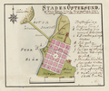
 18th century map of Nyköping, Sweden.jpg 4,313 × 3,644; 1.02 MB
-
 18th century map of Piteå, Sweden.jpg 4,006 × 3,048; 666 KB
-
 18th century map of Sala, Sweden.jpg 3,970 × 3,252; 715 KB
-
 18th century map of Simrishamn, Sweden.jpg 4,554 × 3,732; 994 KB
-
 18th century map of Skanör, Sweden.jpg 3,808 × 3,248; 766 KB
-
 18th century map of Skara, Sweden.jpg 3,868 × 3,200; 682 KB
-
 18th century map of Skänninge, Sweden.jpg 4,104 × 3,359; 867 KB
-
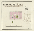
 18th century map of Skövde, Sweden.jpg 3,588 × 3,121; 603 KB
-
 18th century map of Strängnäs, Sweden.jpg 3,797 × 3,057; 725 KB
-
 18th century map of Strömstad, Sweden.jpg 4,457 × 3,109; 764 KB
-
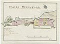 18th century map of Sundsvall, Sweden.jpg 4,229 × 3,153; 805 KB
-
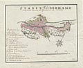 18th century map of Söderhamn, Sweden.jpg 3,845 × 3,141; 810 KB
-
 18th century map of Söderköping, Sweden.jpg 4,040 × 3,275; 879 KB
-
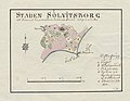 18th century map of Sölvesborg, Sweden.jpg 3,329 × 2,590; 493 KB
-
 18th century map of Torshälla, Sweden.jpg 3,747 × 2,974; 684 KB
-
 18th century map of Trosa, Sweden.jpg 3,819 × 2,866; 619 KB
-
 18th century map of Uddevalla, Sweden.jpg 3,953 × 3,405; 777 KB
-
 18th century map of Ulricehamn, Sweden.jpg 4,240 × 3,237; 723 KB
-
 18th century map of Umeå, Sweden.jpg 3,829 × 3,083; 638 KB
-
 18th century map of Uppsala, Sweden.jpg 3,250 × 4,153; 1.06 MB
-
 18th century map of Vadstena, Sweden.jpg 4,292 × 3,188; 848 KB
-
 18th century map of Varberg, Sweden.jpg 3,765 × 2,952; 587 KB
-
 18th century map of Vaxholm, Sweden.jpg 3,189 × 2,469; 512 KB
-
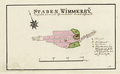
 18th century map of Vimmerby, Sweden.jpg 3,924 × 2,543; 526 KB
-
 18th century map of Visby, Sweden.jpg 4,008 × 3,251; 1.02 MB
-
 18th century map of Vänersborg, Sweden.jpg 3,744 × 3,081; 723 KB
-
 18th century map of Västervik, Sweden.jpg 3,745 × 3,009; 759 KB
-
 18th century map of Västerås, Sweden.jpg 4,152 × 3,334; 966 KB
-
 18th century map of Ystad, Sweden.jpg 4,128 × 2,927; 846 KB
-
 18th century map of Ängelholm, Sweden.jpg 3,982 × 3,082; 734 KB
-
 18th century map of Åmål, Sweden.jpg 3,670 × 3,046; 633 KB
-
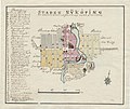
 18th century map of Örebro, Sweden.jpg 3,068 × 4,584; 949 KB
-
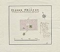
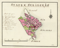
 18th century map of Östersund, Sweden.jpg 3,616 × 3,032; 717 KB
-
 18th century map of Östhammar, Sweden.jpg 3,832 × 2,996; 647 KB
-
 Wiblingen Arboga.png 2,421 × 1,965; 4.91 MB
-
 Wiblingen Askersund.png 2,601 × 1,965; 4.88 MB
-
 Wiblingen Borås.png 2,289 × 1,773; 4.08 MB
-
 Wiblingen Eksjö.png 2,325 × 2,085; 4.9 MB
-
 Wiblingen Enköping.png 2,253 × 1,977; 4.13 MB
-
 Wiblingen Eskilstuna.png 2,577 × 2,193; 5.49 MB
-
 Wiblingen Falkenberg.png 1,916 × 1,739; 3.3 MB
-
 Wiblingen Falköping.png 2,300 × 1,463; 3.26 MB
-
 Wiblingen Falsterbo.png 1,892 × 2,004; 3.76 MB
-
 Wiblingen Filipstad.png 2,659 × 1,860; 4.63 MB
-
 Wiblingen Gränna.png 2,323 × 1,847; 4.26 MB
-
 Wiblingen Gävle.png 2,719 × 2,051; 7.65 MB
-
 Wiblingen Halmstad.png 2,192 × 1,679; 3.34 MB
-
 Wiblingen Hedemora.png 2,300 × 1,835; 4.4 MB
-
 Wiblingen Hjo.png 2,252 × 1,716; 3.54 MB
-
 Wiblingen Hudiksvall.png 2,276 × 1,788; 4.35 MB
-
 Wiblingen Härnösand.png 2,359 × 2,051; 5.44 MB
-
 Wiblingen Jönköping.png 2,707 × 1,799; 5.47 MB
-
 Wiblingen Kalmar.png 2,505 × 1,966; 5.78 MB
-
 Wiblingen Karlshamn.png 2,109 × 1,918; 4.69 MB
-
 Wiblingen Karlstad.png 2,493 × 1,894; 4.73 MB
-
 Wiblingen Kristianstad.png 1,786 × 2,444; 4.67 MB
-
 Wiblingen Kristinehamn.png 2,385 × 1,918; 4.47 MB
-
 Wiblingen Kungsbacka.png 2,373 × 1,750; 3.64 MB
-
 Wiblingen Kungälv.png 2,469 × 1,906; 4.88 MB
-
 Wiblingen Landskrona.png 2,373 × 1,857; 4.59 MB
-
 Wiblingen Lidköping.png 2,313 × 1,989; 4.71 MB
-
 Wiblingen Lindesberg.png 2,301 × 1,870; 4.64 MB
-
 Wiblingen Linköping.png 2,577 × 2,157; 5.71 MB
-
 Wiblingen Luleå.png 2,157 × 1,693; 3.48 MB
-
 Wiblingen Lund.png 2,573 × 2,053; 7.33 MB
-
 Wiblingen Malmköping.png 2,277 × 1,773; 3.89 MB
-
 Wiblingen Malmö.png 3,999 × 2,683; 15.35 MB
-
 Wiblingen Mariefred.png 2,479 × 1,822; 4.61 MB
-
 Wiblingen Mariestad.png 2,223 × 1,774; 3.88 MB
-
 Wiblingen Marstrand.png 2,431 × 3,179; 8.63 MB
-
 Wiblingen Nora.png 2,191 × 1,918; 3.97 MB
-
 Wiblingen Norrköping.png 3,407 × 2,365; 10.37 MB
-
 Wiblingen Norrtälje.png 2,287 × 1,597; 3.92 MB
-
 Wiblingen Nyköping.png 2,615 × 2,205; 6.7 MB
-
 Wiblingen Piteå.png 2,303 × 1,713; 3.68 MB
-
 Wiblingen Sala.png 2,351 × 1,845; 4.2 MB
-
 Wiblingen Simrishamn.png 2,447 × 1,905; 5.11 MB
-
 Wiblingen Skanör.png 2,135 × 1,798; 4.35 MB
-
 Wiblingen Skara.png 2,267 × 1,834; 4.08 MB
-
 Wiblingen Skänninge.png 2,531 × 2,001; 5.21 MB
-
 Wiblingen Skövde.png 1,823 × 1,642; 3.08 MB
-
 Wiblingen Strängnäs.png 2,291 × 1,834; 4.41 MB
-
 Wiblingen Strömstad.png 2,411 × 1,690; 4.04 MB
-
 Wiblingen Sundsvall.png 2,615 × 1,846; 4.88 MB
-
 Wiblingen Säter.png 2,435 × 1,882; 4.85 MB
-
 Wiblingen Söderhamn.png 2,253 × 1,810; 4.61 MB
-
 Wiblingen Söderköping.png 2,493 × 1,954; 5.2 MB
-
 Wiblingen Södertälje.png 2,349 × 1,858; 4.28 MB
-
 Wiblingen Sölvesborg.png 2,014 × 1,546; 3.12 MB
-
 Wiblingen Torshälla.png 2,277 × 1,798; 4.04 MB
-
 Wiblingen Trosa.png 2,325 × 1,738; 3.76 MB
-
 Wiblingen Uddevalla.png 2,048 × 1,823; 4.34 MB
-
 Wiblingen Ulricehamn.png 2,227 × 1,703; 3.79 MB
-
 Wiblingen Umeå.png 2,083 × 1,680; 3.44 MB
-
 Wiblingen Uppsala.png 2,047 × 2,580; 6.92 MB
-
 Wiblingen Varberg.png 2,012 × 1,547; 3.05 MB
-
 Wiblingen Vaxholm.png 1,870 × 1,437; 3.04 MB
-
 Wiblingen Vimmerby.png 2,373 × 1,461; 3.21 MB
-
 Wiblingen Visby.png 2,529 × 1,989; 6.78 MB
-
 Wiblingen Vänersborg.png 2,301 × 1,905; 4.53 MB
-
 Wiblingen Västervik.png 2,277 × 1,844; 4.85 MB
-
 Wiblingen Västerås.png 2,589 × 2,120; 6.24 MB
-
 Wiblingen Wadstena.png 2,347 × 1,643; 4.46 MB
-
 Wiblingen Ystad.png 2,411 × 1,749; 5.1 MB
-
 Wiblingen Ängelholm.png 2,327 × 1,833; 4.44 MB
-
 Wiblingen Åmål.png 2,243 × 1,881; 4.24 MB
-
 Wiblingen Örebro.png 1,835 × 2,852; 6.35 MB
-
 Wiblingen Östersund.png 2,099 × 1,761; 4.27 MB
-
 Wiblingen Östhammar.png 2,279 × 1,797; 3.96 MB


