Help
Category
:
Maps created in 1985
From Wikimedia Commons, the free media repository
Jump to navigation
Jump to search
1980s maps
←
1981
1985
English:
Maps created in the year
1985
See also category:
Maps showing 1985
.
Media in category "Maps created in 1985"
The following 4 files are in this category, out of 4 total.
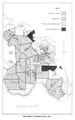
“Map Eleven; The Mackay district, 1863”, in; Clive Moore, Kanaka; A History of Melanesian Mackay, Port Moresby, Institute of Papua New Guinea Studies and University of Papua New Guinea Press, 1985, p. 107.pdf
683 × 1,089; 1.27 MB
“Map Fourteen; The Mackay district, 1883”, in; Clive Moore, Kanaka; A History of Melanesian Mackay, Port Moresby, Institute of Papua New Guinea Studies and University of Papua New Guinea Press, 1985, p. 111.pdf
677 × 1,087; 1.38 MB
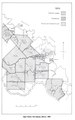
“Map Thirteen; The Mackay district, 1877”, in; Clive Moore, Kanaka; A History of Melanesian Mackay, Port Moresby, Institute of Papua New Guinea Studies and University of Papua New Guinea Press, 1985, p. 110.pdf
685 × 1,095; 1.66 MB
“Map Twelve; The Mackay district, 1869”, in; Clive Moore, Kanaka; A History of Melanesian Mackay, Port Moresby, Institute of Papua New Guinea Studies and University of Papua New Guinea Press, 1985, p. 108.pdf
683 × 1,091; 1.7 MB
Categories
:
1985 maps
1985 works
Maps by year created
Navigation menu
Personal tools
English
Not logged in
Talk
Contributions
Create account
Log in
Namespaces
Category
Discussion
English
Views
View
Edit
History
More
Search
Navigate
Main page
Welcome
Community portal
Village pump
Help center
Participate
Upload file
Recent changes
Latest files
Random file
Contact us
Tools
What links here
Related changes
Special pages
Permanent link
Page information
Get shortened URL
Download QR code
Print/export
Create a book
Download as PDF
Printable version
In Wikipedia
Add links