Category:Maps by John Thomson
Jump to navigation
Jump to search
Subcategories
This category has only the following subcategory.
N
Media in category "Maps by John Thomson"
The following 41 files are in this category, out of 41 total.
-
 1813 Thomson Map of Africa - Geographicus - Africa-thomson-1813.jpg 5,000 × 4,420; 6.23 MB
-
-
 1814 Thomson Map of Bavaria, Germany - Geographicus - Bavaria-t-1814.jpg 2,500 × 2,131; 1.34 MB
-
 1814 Thomson Map of France - Geographicus - France-t-1814.jpg 6,000 × 5,160; 9.18 MB
-

-
 1814 Thomson Map of India - Geographicus - IndiaSouth-t-1814.jpg 3,300 × 2,799; 2.37 MB
-
 1814 Thomson Map of India w-Ganges - Geographicus - Hindoostan-t-1814.jpg 5,000 × 3,779; 4.41 MB
-

-
 1814 Thomson Map of Mexico and Texas - Geographicus - SpanishNorthAmerica-thomson-1814.jpg 5,000 × 4,107; 6.03 MB
-
 1814 Thomson Map of North America - Geographicus - NorthAmerica-thomson-1814.jpg 4,000 × 3,343; 3.3 MB
-
 1814 Thomson Map of North and South America - Geographicus - America-t-1815.jpg 3,500 × 3,123; 2.41 MB
-
 1814 Thomson Map of Northern India and Nepal - Geographicus - IndiaNepal-t-1814.jpg 3,300 × 2,752; 2.88 MB
-
 1814 Thomson Map of Southern Ireland - Geographicus - IrelandSouth-t-1814.jpg 4,000 × 3,370; 2.5 MB
-

-
 1814 Thomson Map of Tartary ( Mongolia, Tibet ) - Geographicus - Tartary-t-1814.jpg 3,500 × 2,912; 2.21 MB
-
 1814 Thomson Map of the Atlantic Ocean - Geographicus - Atlantic-t-1814.jpg 5,000 × 3,990; 2.94 MB
-
 1814 Thomson Map of the English Channel - Geographicus - BritishChannel-thomson-1814.jpg 5,000 × 4,029; 4.94 MB
-
-

-
 1814 Thomson Map of the West Indies ^ Central America - Geographicus - WestIndies-t-1814.jpg 5,000 × 4,215; 4.41 MB
-

-
 1814 Thomson Map of Tuscany (Florence), Italy - Geographicus - Tuscany-t-1814.jpg 3,000 × 3,602; 2.76 MB
-
 1815 map of China.jpg 12,496 × 14,332; 30.94 MB
-
 1815 Thomson Map of Attica (Anthens and Vicinity) Greece - Geographicus - Attica-t-1814.jpg 4,010 × 5,604; 3.19 MB
-
 1815 Thomson Map of China and Formosa (Taiwan) - Geographicus - China-t-15.jpg 3,000 × 3,394; 3.11 MB
-
 1815 Thomson Map of Cuba. Bermuda ^ the Bahamas - Geographicus - Cuba-t-1816.jpg 3,500 × 2,993; 2.07 MB
-
-
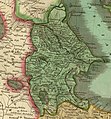
 1815 Thomson Map of Prussia, Germany - Geographicus - Prussia-t-15.jpg 5,000 × 4,212; 3.61 MB
-
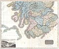 1815 Thomson Map of Southern Scotland - Geographicus - ScotlandSouth-t-15.jpg 5,000 × 4,224; 3.74 MB
-
 1815 Thomson Map of Spain and Portugal - Geographicus - Spain-t-15.jpg 3,000 × 2,515; 2.05 MB
-

-
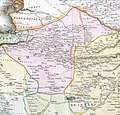
 1817 Thomson Map of Persia. Caucasia.jpg 1,725 × 1,857; 1.27 MB
-
 1817 Thomson Map of Persia.jpg 11,409 × 6,992; 24.66 MB
-
 Broughton, Glenholm and Kilbucho map.jpg 1,098 × 1,432; 1.92 MB
-
 Chart of the Northern Passage Between Asia & America.jpg 15,190 × 12,891; 19.52 MB
-
 Corea and Japan.jpg 15,913 × 12,776; 25.78 MB
-

-
 Khorasan in Safavid age.jpg 1,284 × 1,231; 1.52 MB
-
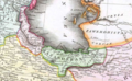 Mazandaran 1814.png 840 × 520; 863 KB
-
 North America (IA McGillLibrary-123913-2189).pdf 2,122 × 1,666; 8.37 MB
-
 Salmas in 1814 Thomson Map of the "Persian Empire".jpg 2,931 × 2,448; 2.85 MB


_and_the_Balkans_-_Geographicus_-_TurkeyEurope-t-1814.jpg)


_-_Geographicus_-_MartiniqueDominica-thomson-1814.jpg)


_-_Geographicus_-_NaplesSicily-t-1814.jpg)
_-_Geographicus_-_Tartary-t-1814.jpg)


,_Italy_-_Geographicus_-_VenetianStates-t-1814.jpg)

_-_Geographicus_-_HemiWest-t-1814.jpg)
,_Italy_-_Geographicus_-_Tuscany-t-1814.jpg)

_Greece_-_Geographicus_-_Attica-t-1814.jpg)
_-_Geographicus_-_China-t-15.jpg)


,_Italy_-_Geographicus_-_MilaneseStates-t-1815.jpg)


