Category:Maps and diagrams of the World Trade Center on 9/11
Jump to navigation
Jump to search
Subcategories
This category has only the following subcategory.
Media in category "Maps and diagrams of the World Trade Center on 9/11"
The following 20 files are in this category, out of 20 total.
-
 911 - FEMA - Areas debris impact (graphic).png 1,014 × 1,351; 322 KB
-
 911 - FEMA - WTC impacts (graphic).png 1,013 × 676; 241 KB
-
 911 - FEMA - WTC impacts (graphic).svg 744 × 501; 127 KB
-
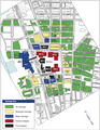 FEMA 403 NYC Cooperative Building Damage Assessment Map of November 7, 2001.png 1,363 × 1,759; 310 KB
-
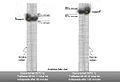
 NorthWTCcollapse.png 2,165 × 1,675; 177 KB
-
 September 11 2001 New York smoke plume.gif 775 × 715; 3.52 MB
-
 World Trade Center 3 After 9-11 Attacks With Original Building Locations.jpg 1,562 × 1,093; 1 MB
-
-
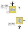
 World Trade Center 9-11 Attacks Illustration with Vertical Impact Locations ar.png 1,458 × 1,008; 89 KB
-

-

-
-

-

-

-
 World Trade Center 9-11 Attacks Illustration with Vertical Impact Locations.jpg 1,388 × 1,003; 171 KB
-
 World Trade Center Site After 9-11 Attacks With Original Building Locations.jpg 2,992 × 2,242; 2.36 MB
-
 WTC disaster area.png 667 × 612; 378 KB
-
 WTC utok - udajne umisteni nalozi.jpg 863 × 950; 81 KB
-
 Wtc20010911.png 279 × 359; 6 KB
.png)
.png)
.svg)


