Category:Mankinholes
Jump to navigation
Jump to search
village in Calderdale, West Yorkshire, United Kingdom | |||||
| Upload media | |||||
| Instance of | |||||
|---|---|---|---|---|---|
| Location | Todmorden, Calderdale, West Yorkshire, Yorkshire and the Humber, England | ||||
 | |||||
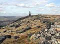
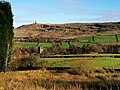
English: Mankinholes is a hamlet in the Metropolitan Borough of Calderdale, in West Yorkshire, England. It is part of the Pennines, and its nearest town is Todmorden in Yorkshire. It has a YHA hostel, managed by the larger hostel at nearby Haworth. Mankinholes is the starting point for the popular trek up Stoodley Pike, "Pike" being a North-country term for a mountain or large hill. The hill is surmounted by a 120-foot high 19th-century obelisk, also known as "Stoodley Pike", commemorating the end of the Crimean War.
Media in category "Mankinholes"
The following 48 files are in this category, out of 48 total.
-
 Bridleway from Mankinholes towards Stoodley Pike. - panoramio.jpg 1,600 × 1,200; 555 KB
-
 Broad Gate near Mankinholes - geograph.org.uk - 881617.jpg 640 × 473; 149 KB
-
 Chimney "Stump", Halifax Road - geograph.org.uk - 1461978.jpg 480 × 640; 82 KB
-
 Dry Brinks, Higher Moor - geograph.org.uk - 362538.jpg 640 × 468; 116 KB
-
 Heeley Hill, Mankinholes - geograph.org.uk - 362521.jpg 640 × 480; 111 KB
-
 Jeremy Hill. - geograph.org.uk - 504012.jpg 640 × 426; 243 KB
-
 Junction of Pennine Way and Long Causeway - geograph.org.uk - 99541.jpg 1,600 × 1,200; 1.11 MB
-
 Leaning stone at Withens Gate (3379664345).jpg 3,843 × 2,527; 6.03 MB
-
 London Road (26796827495).jpg 3,452 × 2,355; 6.38 MB
-
 London Road, Mankinholes - geograph.org.uk - 1103036.jpg 640 × 480; 122 KB
-
 Long Causeway, near Stoodley Pike (October 2010). - panoramio.jpg 1,600 × 1,200; 316 KB
-
 Looking towards Stoodley Pike, West Yorkshire - panoramio (1).jpg 1,600 × 1,200; 269 KB
-
 Looking towards Stoodley Pike, West Yorkshire - panoramio.jpg 1,600 × 1,200; 242 KB
-
 Mankinholes (26357070092).jpg 3,930 × 2,620; 8.09 MB
-
 Mankinholes (27755957404).jpg 3,864 × 1,717; 5.88 MB
-
 Mankinholes , Cross lane - geograph.org.uk - 1255313.jpg 640 × 427; 79 KB
-
 Mankinholes - welcome sheep at start of village. - panoramio.jpg 1,600 × 1,200; 341 KB
-
 Mankinholes 2020.jpg 3,648 × 2,736; 1.37 MB
-
 Mankinholes Bank - geograph.org.uk - 1013011.jpg 640 × 480; 215 KB
-
 Mankinholes from Mankinholes Bank - geograph.org.uk - 1250008.jpg 640 × 427; 62 KB
-
 Mankinholes Graveyard (26406393016).jpg 2,766 × 3,878; 8.73 MB
-
 Mankinholes Hall in 1984 - geograph.org.uk - 1950357.jpg 863 × 572; 110 KB
-
 Mankinholes in 1984 - geograph.org.uk - 2204196.jpg 993 × 660; 142 KB
-

-
 Mankinholes Millennium Sculpture - geograph.org.uk - 978943.jpg 640 × 480; 79 KB
-
 Mankinholes Village - geograph.org.uk - 1258198.jpg 640 × 427; 87 KB
-
 Mankinholes, Date stone - geograph.org.uk - 2162368.jpg 640 × 480; 193 KB
-
 Old Wayside Cross (geograph 6560351).jpg 720 × 960; 150 KB
-
 Packhorse way at Mankinholes, Langfield - geograph.org.uk - 94336.jpg 480 × 640; 190 KB
-
 Pennine Bridleway, Mankinholes - geograph.org.uk - 881632.jpg 640 × 468; 120 KB
-
 Pennine Way, Langfield Common - geograph.org.uk - 42987.jpg 640 × 427; 101 KB
-
 Permissive Bridleway to Cragg Vale via Long Causeway. - panoramio.jpg 1,600 × 1,200; 237 KB
-
 Road through Mankinholes, taken from beside YHA entrance. - panoramio.jpg 1,600 × 1,200; 516 KB
-
 The Long Causeway - geograph.org.uk - 39664.jpg 1,600 × 1,200; 808 KB
-
 Water troughs at Mankinholes - geograph.org.uk - 1083393.jpg 640 × 480; 118 KB
-
 Water troughs at Moore Edge - geograph.org.uk - 1255293.jpg 640 × 427; 96 KB
-
 White Holme Drain - geograph.org.uk - 915515.jpg 640 × 480; 109 KB
-
 Boundary stones on Langfield Common - geograph.org.uk - 235253.jpg 640 × 480; 160 KB
-
 Eastern Half of Gaddings Dam. - geograph.org.uk - 503108.jpg 640 × 427; 232 KB
-
 Eastern Side of Gaddings Dam. - geograph.org.uk - 503105.jpg 640 × 426; 247 KB
-
 High Stones, Higher Moor - geograph.org.uk - 362534.jpg 640 × 480; 123 KB
-
 High Stones, The Pennine Way - geograph.org.uk - 288282.jpg 640 × 480; 120 KB
-
 Long Stoup and the Pennine Way - geograph.org.uk - 362526.jpg 640 × 480; 104 KB
-
 Mankinholes - geograph.org.uk - 86689.jpg 640 × 480; 122 KB
-
 Mankinholes Hall (Youth Hostel) - geograph.org.uk - 94338.jpg 640 × 480; 132 KB
-
 Mankinholes. - geograph.org.uk - 504026.jpg 640 × 426; 241 KB
-
 The Long Causeway - geograph.org.uk - 288264.jpg 480 × 640; 93 KB
-
 Towards the Long Causeway from Mankinholes - geograph.org.uk - 39659.jpg 1,600 × 1,200; 788 KB


.jpg)
.jpg)

._-_panoramio.jpg)
.jpg)

.jpg)
.jpg)


.jpg)


.jpg)


_-_geograph.org.uk_-_94338.jpg)


