Category:Macleod, Victoria
Jump to navigation
Jump to search
suburb of Melbourne, Victoria, Australia | |||||
| Upload media | |||||
| Instance of | |||||
|---|---|---|---|---|---|
| Location | |||||
| Population |
| ||||
| Elevation above sea level |
| ||||
 | |||||
Media in category "Macleod, Victoria"
The following 17 files are in this category, out of 17 total.
-
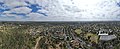 Aerial panorama of Macleod facing east towards the Dandenong Ranges. February 2024.jpg 8,192 × 3,326; 8.97 MB
-
 Aerial panorama of Macleod facing west towards the Melbourne skyline. February 2024.jpg 8,192 × 3,324; 9.65 MB
-
 Dunvegan Estate - Final Plan.svg 512 × 465; 1.48 MB
-
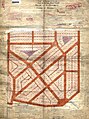
 Dunvegan Estate - Original Survey.png 1,000 × 1,679; 2.65 MB
-
 Golf Links Estate, Macleod.png 3,417 × 4,975; 31.02 MB
-
 Macleod (V.C.) Estate - Lodged Plan.jpg 2,000 × 2,681; 5.92 MB
-
 Macleod (VC) Estate - Current Layout.svg 512 × 386; 1.42 MB
-
 Macleod Railway Station.jpg 6,016 × 4,000; 5.73 MB
-
 Macleod1.jpg 512 × 384; 153 KB
-
 Macleod2.jpg 512 × 493; 177 KB
-
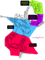 Old Hospitals in the Mont Park complex.svg 512 × 686; 394 KB
-
 River Gum Walk Trail next to Greensborough Road, Rosanna (32054027346).jpg 2,448 × 3,264; 2.91 MB
-
 Springthorpe Estate, Macleod.jpg 3,264 × 2,448; 2.7 MB
-
 Springthorpe Estate.svg 512 × 683; 3 MB
-
 Springthorpe logo.svg 512 × 120; 16 KB
-
 Strathallan Estate - Parts 1 and 2.svg 512 × 523; 3.59 MB
-
 Survey Plan for part of Macleod Golf Links Estate.png 6,967 × 4,925; 62.51 MB


_Estate_-_Lodged_Plan.jpg)
_Estate_-_Current_Layout.svg)


.jpg)


