Category:Lytham St Annes
Jump to navigation
Jump to search
town in the Fylde district of Lancashire, England   | |||||
| Upload media | |||||
| Instance of |
| ||||
|---|---|---|---|---|---|
| Location | Fylde, Lancashire, North West England, England | ||||
| Population |
| ||||
| official website | |||||
 | |||||
Subcategories
This category has the following 9 subcategories, out of 9 total.
Media in category "Lytham St Annes"
The following 85 files are in this category, out of 85 total.
-
 "Play it again Sam" - geograph.org.uk - 1266737.jpg 640 × 480; 82 KB
-

-
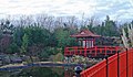 A little bit of Japan in St Annes - geograph.org.uk - 99595.jpg 640 × 372; 135 KB
-
 AKS Lytham.png 900 × 900; 706 KB
-
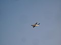 BAe 146 - geograph.org.uk - 996665.jpg 640 × 480; 241 KB
-
 Bandstand and Mexico memorial - panoramio.jpg 3,888 × 2,592; 3.12 MB
-
 Bandstand at St Annes - panoramio - jolmartyn.jpg 3,888 × 2,592; 3.03 MB
-
 Bandstand at St Annes - panoramio.jpg 3,888 × 2,592; 2.5 MB
-
 Barrow and Assistants.jpg 1,558 × 1,104; 464 KB
-
 Beach Huts (44573737021).jpg 5,775 × 3,816; 2.4 MB
-
 Bench at Lytham St Annes - geograph.org.uk - 1591703.jpg 640 × 427; 105 KB
-
 Blackpool Road North playing fields - panoramio (1).jpg 3,072 × 2,304; 2.8 MB
-
 Blackpool Road North playing fields - panoramio (2).jpg 3,072 × 2,304; 3.04 MB
-
 Blackpool Road North playing fields - panoramio.jpg 2,304 × 3,072; 2.84 MB
-
 BlackpoolBUA.png 413 × 850; 422 KB
-
 Church Road looking north - panoramio.jpg 3,888 × 2,592; 3.27 MB
-
 Church road looking south - panoramio.jpg 3,888 × 2,592; 3.09 MB
-
 Clifton Drive, looking North, St Annes, 2010 - panoramio.jpg 3,072 × 2,304; 3.02 MB
-
 Conservation area, Lytham St Annes - DSC07136.JPG 3,648 × 2,736; 3.64 MB
-
 Digging a path to the beach - geograph.org.uk - 862444.jpg 640 × 401; 39 KB
-
 Eastern Promenade, Lytham - geograph.org.uk - 996647.jpg 640 × 480; 57 KB
-
 Entrance to Pleasure Island (now closed) - panoramio.jpg 3,888 × 2,592; 2.76 MB
-
 Fairhaven Lake - geograph.org.uk - 1724875.jpg 640 × 312; 79 KB
-
 Fairhaven Lake in Lytham St Annes - geograph.org.uk - 1591705.jpg 640 × 427; 58 KB
-
 Fairhaven Lake in Lytham St Annes - geograph.org.uk - 1591708.jpg 640 × 420; 45 KB
-
 Fairhaven Lake in Lytham St Annes - geograph.org.uk - 1591712.jpg 640 × 413; 44 KB
-
 Feeding the geese - geograph.org.uk - 1724873.jpg 640 × 361; 105 KB
-

-
 Fylde Rugby Union Ground - geograph.org.uk - 1148160.jpg 640 × 480; 75 KB
-
 George Formby's house - Geograph 3380229.jpg 1,083 × 788; 1.14 MB
-
 Graham Parish pic.jpg 263 × 403; 20 KB
-
 Jeff Thomas (boxer).jpg 600 × 450; 42 KB
-
 Lands End - geograph.org.uk - 996610.jpg 640 × 480; 147 KB
-

-
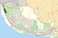 Location map United Kingdom Lytham St Annes.svg 398 × 263; 1.1 MB
-
 Looking West from the Sandunes at St Annes - panoramio.jpg 5,000 × 710; 2.18 MB
-
 Lytham Creek - geograph.org.uk - 740420.jpg 640 × 480; 83 KB
-
 Lytham Green - geograph.org.uk - 1588174.jpg 640 × 427; 59 KB
-
 Lytham Green - geograph.org.uk - 1588184.jpg 640 × 413; 60 KB
-
 Lytham jetty - geograph.org.uk - 1266805.jpg 480 × 640; 70 KB
-
 Lytham St Anne's (14441246080).jpg 1,200 × 981; 658 KB
-
 Lytham St Anne's (14627906565).jpg 1,063 × 1,200; 704 KB
-
 Lytham St Anne's - geograph.org.uk - 939632.jpg 620 × 482; 66 KB
-
 Lytham St Anne's - Lancashire dot.png 417 × 599; 122 KB
-
 Lytham St Annes (14233479692).jpg 1,400 × 1,580; 855 KB
-
 Lytham St Annes (14255929373).jpg 1,580 × 1,291; 857 KB
-
 Lytham St Annes High School Logo.jpg 516 × 269; 24 KB
-
 Lytham St Annes, England, 2017.jpg 6,553 × 4,369; 14.39 MB
-

-
 Navigation marker no 13 - geograph.org.uk - 878510.jpg 480 × 640; 68 KB
-
 Ordnance Survey One-Inch Sheet 94 Preston, Published 1947.jpg 10,969 × 12,750; 17.44 MB
-
 Ordnance Survey One-Inch Sheet 94 Preston, Published 1961.jpg 8,262 × 9,863; 12.33 MB
-
 Queens Manor, Lytham St Annes, Lancashire - DSC07134.JPG 3,648 × 2,736; 3.63 MB
-
 Queens Manor, Lytham St Annes, Lancashire - DSC07135.JPG 3,648 × 2,736; 3.62 MB
-
 R C C (Ribble Cruising Club) - geograph.org.uk - 996650.jpg 640 × 480; 60 KB
-
 Razgledica od Sent An, 1923.jpg 1,613 × 1,013; 546 KB
-
 Ribble Estuary - geograph.org.uk - 1047153.jpg 640 × 440; 97 KB
-
 RNLI Shop - geograph.org.uk - 848762.jpg 640 × 480; 47 KB
-
 Sail Boat Fairhaven Lake - geograph.org.uk - 1610612.jpg 640 × 480; 89 KB
-
 Skateboard park at Fairhaven - geograph.org.uk - 1590174.jpg 640 × 425; 262 KB
-
 St Albans Road looking West - panoramio.jpg 3,888 × 2,592; 1.51 MB
-
 St Annes beach - panoramio.jpg 3,888 × 2,592; 3.55 MB
-
 St Annes beach looking South - panoramio.jpg 3,888 × 2,592; 3.1 MB
-
 St Annes crescent looking to the sea - panoramio.jpg 3,888 × 2,592; 3.34 MB
-
 St Annes Pier from town hall - panoramio.jpg 3,888 × 2,592; 2.77 MB
-
 St Annes pier from town hall - panoramio.jpg 3,888 × 2,592; 3.46 MB
-
 St Annes promenade looking South - panoramio.jpg 3,888 × 2,592; 3.24 MB
-
 St Annes Sand dunes in winter - panoramio.jpg 3,072 × 2,304; 2.8 MB
-
 St Annes seafront gardens - panoramio.jpg 3,888 × 2,592; 3.14 MB
-
 St Annes Sunset.jpg 3,840 × 2,160; 313 KB
-
 St Annes Swimming Pool - panoramio.jpg 3,888 × 2,592; 3.17 MB
-
 St Annes Swimming Pool - YMCA - panoramio.jpg 3,888 × 2,592; 2.99 MB
-
 St Annes town hall entrance - panoramio.jpg 3,888 × 2,592; 3.46 MB
-
 St Annes Townhall - panoramio.jpg 3,888 × 2,592; 3.41 MB
-
 St Annes YMCA - panoramio.jpg 3,888 × 2,592; 3.08 MB
-
 St Cuthbert's Cross, Church road, Lytham - panoramio.jpg 3,888 × 2,592; 5.1 MB
-
 The Beach near Fairhaven - geograph.org.uk - 741278.jpg 640 × 365; 57 KB
-
 The Jetty - geograph.org.uk - 848763.jpg 640 × 480; 67 KB
-
 The jetty at Lytham - geograph.org.uk - 1587728.jpg 640 × 454; 57 KB
-
 The Lancashire Coastal Way in Lytham - geograph.org.uk - 1591695.jpg 640 × 427; 44 KB
-
 The Ribble Estuary - geograph.org.uk - 1588181.jpg 640 × 411; 76 KB
-
 Waterway - Flickr - Clive Varley.jpg 1,750 × 1,160; 1.37 MB
-
 Waves in the Sand - geograph.org.uk - 652435.jpg 640 × 426; 271 KB
-
 When I was a lad - geograph.org.uk - 996624.jpg 640 × 480; 33 KB
-
 Brim Full - geograph.org.uk - 76895.jpg 640 × 480; 161 KB

_Henry_Street,_Lytham_St._Annes,_Lancashire,_FY8_5LE_-_geograph.org.uk_-_1738586.jpg)


.jpg)

.jpg)
.jpg)


_-_panoramio.jpg)


.jpg)


.jpg)
.jpg)


.jpg)
.jpg)


_-_geograph.org.uk_-_996650.jpg)


