Category:Lutheran church in Albrechtice (Karviná District)
Jump to navigation
Jump to search
| Object location | | View all coordinates using: OpenStreetMap |
|---|
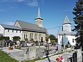
church building in Albrechtice, Czech Republic ,_evangelick%C3%BD_kostel.jpg)  | |||||
| Upload media | |||||
| Instance of | |||||
|---|---|---|---|---|---|
| Location | Albrechtice, Karviná District, Moravian-Silesian Region, Czechia | ||||
| Owned by | |||||
| Inception |
| ||||
| Religion or worldview | |||||
 | |||||
Subcategories
This category has only the following subcategory.
Media in category "Lutheran church in Albrechtice (Karviná District)"
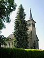
The following 6 files are in this category, out of 6 total.
-
 2018 Hřbitov Albrechtice (KA) 01.jpg 3,264 × 2,448; 2.5 MB
-
 2018 Hřbitov Albrechtice (KA) 02 Michejdovi.jpg 2,448 × 3,264; 2.73 MB
-
 Albrechtice (KA), evangelická fara.jpg 4,896 × 3,672; 5.9 MB
-
 Albrechtice (KA), evangelický kostel.jpg 3,672 × 4,896; 5.15 MB
-
 Albrechtice evangelicky kostel 2.JPG 2,448 × 3,264; 1.4 MB
-
 Albrechtice evangelicky kostel.JPG 3,262 × 2,356; 1.76 MB
_01.jpg)
_02_Michejdovi.jpg)
,_evangelick%C3%A1_fara.jpg)

