Category:Lower Shabele Region
Jump to navigation
Jump to search
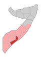
English: Lower Shabele
Soomaaliga: Shabeellaha Hoose
region of Somalia   | |||||
| Upload media | |||||
| Instance of | |||||
|---|---|---|---|---|---|
| Location | Somalia | ||||
| Capital | |||||
| Area |
| ||||
 | |||||
Subcategories
This category has the following 4 subcategories, out of 4 total.
Media in category "Lower Shabele Region"
The following 104 files are in this category, out of 104 total.
-
 Lower Shabeelle State flag.jpg 992 × 768; 72 KB
-
 Somalia regions map Shabeellaha Hoose.svg 744 × 1,052; 28 KB
-
 2013 01 09 AMISOM Frontline C (8370005814).jpg 7,250 × 4,839; 1.3 MB
-
 2013 01 10 AMISOM Frontline C (8368955323).jpg 7,215 × 4,815; 1.06 MB
-
 2013 02 12 AMISOM Advance Day1 A (8543821469).jpg 4,256 × 2,832; 1.03 MB
-
 2013 02 12 AMISOM Advance Day1 B (8543820711).jpg 3,885 × 2,585; 865 KB
-
 2013 02 12 AMISOM Advance Day1 C (8544916254).jpg 4,229 × 2,814; 1.04 MB
-
 2013 02 12 AMISOM Advance Day1 D (8543819397).jpg 4,089 × 2,721; 1.11 MB
-
 2013 02 12 AMISOM Advance Day1 E (8543818535).jpg 4,256 × 2,832; 1.17 MB
-
 2013 02 12 AMISOM Advance Day1 F (8544913402).jpg 4,169 × 2,774; 1.23 MB
-
 2013 02 13 AMISOM Advance Day2 A (8543824443).jpg 7,090 × 4,731; 1.22 MB
-
 2013 02 13 AMISOM Advance Day2 B (8543823991).jpg 7,062 × 4,713; 1.09 MB
-
 2013 02 13 AMISOM Advance Day2 C (8544919824).jpg 4,023 × 2,677; 1.26 MB
-
 2013 02 13 AMISOM Advance Day2 D (8543822105).jpg 4,199 × 2,794; 1.08 MB
-
 2013 02 13 AMISOM Advance Day2 E (8543816679).jpg 4,227 × 2,813; 1.05 MB
-
 2013 02 14 AMISOM Advance Day3 A (8543802407).jpg 4,256 × 2,832; 1.15 MB
-
 2013 02 14 AMISOM Advance Day3 B (8543801985).jpg 7,360 × 4,912; 1.19 MB
-
 2013 02 14 AMISOM Advance Day3 C (8543801187).jpg 7,360 × 4,912; 1.24 MB
-
 2013 02 14 AMISOM Advance Day3 D (8544896596).jpg 7,190 × 4,799; 1.25 MB
-
 2013 02 14 AMISOM Advance Day3 G (8543798663).jpg 4,256 × 2,832; 1.29 MB
-
 2013 02 14 AMISOM Advance Day3 H (8543797939).jpg 4,173 × 2,777; 1.24 MB
-
 2013 02 14 AMISOM Advance Day3 I (8543797119).jpg 7,198 × 4,804; 1.27 MB
-
 2013 02 14 AMISOM Advance Day3 J (8544892696).jpg 7,360 × 4,912; 1.3 MB
-
 2013 02 14 AMISOM Advance Day3 L (8544891528).jpg 4,712 × 7,060; 1.23 MB
-
 2014 03 21 Qoryooley Camp-1 (13360105533).jpg 4,256 × 2,832; 1.25 MB
-
 2014 03 21 Qoryooley Camp-10 (13359911975).jpg 4,256 × 2,832; 1.24 MB
-
 2014 03 21 Qoryooley Camp-2 (13360328724).jpg 4,256 × 2,832; 1.05 MB
-
 2014 03 21 Qoryooley Camp-3 (13360099083).jpg 4,191 × 2,789; 1.18 MB
-
 2014 03 21 Qoryooley Camp-4 (13360322064).jpg 4,256 × 2,832; 1.45 MB
-
 2014 03 21 Qoryooley Camp-5 (13360317694).jpg 4,121 × 2,742; 1.38 MB
-
 2014 03 21 Qoryooley Camp-6 (13360313324).jpg 4,097 × 2,726; 1.29 MB
-
 2014 03 21 Qoryooley Camp-7 (13360081343).jpg 4,164 × 2,771; 1.17 MB
-
 2014 03 21 Qoryooley Camp-8 (13360303504).jpg 4,256 × 2,832; 1.27 MB
-
 2014 03 21 Qoryooley Camp-9 (13359916235).jpg 2,616 × 3,931; 1.17 MB
-
 2014 03 21 Qoryooley Capture-1 (13345620004).jpg 4,011 × 2,669; 1.42 MB
-
 2014 03 21 Qoryooley Capture-10 (13345349873).jpg 7,360 × 4,912; 1.34 MB
-
 2014 03 21 Qoryooley Capture-11 (13345347803).jpg 4,188 × 2,787; 1.44 MB
-
 2014 03 21 Qoryooley Capture-12 (13345345673).jpg 4,108 × 2,734; 1.38 MB
-
 2014 03 21 Qoryooley Capture-13 (13345343503).jpg 3,789 × 2,521; 1.15 MB
-
 2014 03 21 Qoryooley Capture-14 (13345210845).jpg 4,092 × 2,723; 1.17 MB
-
 2014 03 21 Qoryooley Capture-15 (13345590674).jpg 4,018 × 2,674; 1.18 MB
-
 2014 03 21 Qoryooley Capture-16 (13345336593).jpg 3,998 × 2,660; 1.22 MB
-
 2014 03 21 Qoryooley Capture-2 (13345617634).jpg 4,567 × 6,843; 1.39 MB
-
 2014 03 21 Qoryooley Capture-3 (13345234285).jpg 6,669 × 4,451; 1.33 MB
-
 2014 03 21 Qoryooley Capture-4 (13345362363).jpg 7,081 × 4,726; 1.29 MB
-
 2014 03 21 Qoryooley Capture-5 (13345229755).jpg 3,880 × 2,582; 1.15 MB
-
 2014 03 21 Qoryooley Capture-6 (13345358153).jpg 4,164 × 2,771; 1.15 MB
-
 2014 03 21 Qoryooley Capture-7 (13345225735).jpg 4,256 × 2,832; 1.25 MB
-
 2014 03 21 Qoryooley Capture-8 (13345223615).jpg 4,256 × 2,832; 1.16 MB
-
 2014 03 21 Qoryooley Capture-9 (13345351873).jpg 6,816 × 4,549; 1.25 MB
-
 2014 03 21 Qoryooley Offensive-1 (13323521055).jpg 4,081 × 2,716; 1.38 MB
-
 2014 03 21 Qoryooley Offensive-12 (13323874054).jpg 7,244 × 4,835; 1.46 MB
-
 2014 03 21 Qoryooley Offensive-2 (13323904224).jpg 2,688 × 4,040; 1.27 MB
-
 2014 03 21 Qoryooley Offensive-3 (13323902704).jpg 4,125 × 2,745; 1.35 MB
-
 2014 03 21 Qoryooley Offensive-4 (13323899534).jpg 4,203 × 2,797; 1.44 MB
-
 2014 03 21 Qoryooley Offensive-5 (13323510985).jpg 6,888 × 4,597; 1.32 MB
-
 2014 03 21 Qoryooley Offensive-6 (13323684623).jpg 3,955 × 2,632; 1.25 MB
-
 2014 03 21 Qoryooley Offensive-7 (13323892844).jpg 7,152 × 4,773; 1.28 MB
-
 2014 03 21 Qoryooley Offensive-8 (13323886074).jpg 7,145 × 4,769; 1.44 MB
-
 2014 03 21 Qoryooley Offensive-9 (13323674893).jpg 7,154 × 4,775; 1.41 MB
-
 2014 08 30 Operation Indian Ocean-1 (14898167967).jpg 4,256 × 2,832; 1.17 MB
-
 2014 08 30 Operation Indian Ocean-10 (14898050969).jpg 3,981 × 2,649; 1.11 MB
-
 2014 08 30 Operation Indian Ocean-11 (15084738195).jpg 4,115 × 2,738; 1.44 MB
-
 2014 08 30 Operation Indian Ocean-12 (14898087600).jpg 4,116 × 2,739; 1.21 MB
-
 2014 08 30 Operation Indian Ocean-13 (15081721611).jpg 4,182 × 2,783; 1.09 MB
-
 2014 08 30 Operation Indian Ocean-14 (14898046049).jpg 6,991 × 4,666; 1.22 MB
-
 2014 08 30 Operation Indian Ocean-15 (14898173447).jpg 4,106 × 2,732; 1.26 MB
-
 2014 08 30 Operation Indian Ocean-16 (14898042389).jpg 3,889 × 2,588; 1.41 MB
-
 2014 08 30 Operation Indian Ocean-2 (15084369212).jpg 4,206 × 2,799; 1.21 MB
-
 2014 08 30 Operation Indian Ocean-3 (14898190257).jpg 4,256 × 2,832; 1.2 MB
-
 2014 08 30 Operation Indian Ocean-4 (15084392202).jpg 4,256 × 2,832; 1.29 MB
-
 2014 08 30 Operation Indian Ocean-5 (15061745906).jpg 3,753 × 2,497; 1.17 MB
-
 2014 08 30 Operation Indian Ocean-6 (15061743996).jpg 3,571 × 2,376; 1.37 MB
-
 2014 08 30 Operation Indian Ocean-7 (14898055339).jpg 2,343 × 3,521; 1.34 MB
-
 2014 08 30 Operation Indian Ocean-8 (14898100560).jpg 4,142 × 2,756; 1.43 MB
-
 2014 08 30 Operation Indian Ocean-9 (15081726211).jpg 3,877 × 2,580; 1.04 MB
-
 2014 08 31 Buulomareer-1 (14905504869).jpg 3,982 × 2,650; 1.36 MB
-
 2014 08 31 Kurtunwaarey-1 (14916008999).jpg 4,080 × 2,715; 1.21 MB
-
 2015 06 22 Torotorow-10 (19078645965).jpg 4,256 × 2,832; 1.28 MB
-
 2015 06 22 Torotorow-11 (19078644875).jpg 3,732 × 2,483; 1.46 MB
-
 2015 06 22 Torotorow-12 (18892459319).jpg 3,584 × 2,385; 1.31 MB
-
 2015 06 22 Torotorow-13 (19052394806).jpg 4,256 × 2,832; 1.22 MB
-
 2015 06 22 Torotorow-14 (19081880171).jpg 4,256 × 2,832; 1.23 MB
-
 2015 06 22 Torotorow-15 (18890895270).jpg 4,256 × 2,832; 1.29 MB
-
 2015 06 22 Torotorow-17 (18457938783).jpg 4,256 × 2,832; 1.22 MB
-
 2015 06 22 Torotorow-18 (18890956848).jpg 3,814 × 2,538; 1.16 MB
-
 2015 06 22 Torotorow-2 (19073012552).jpg 3,796 × 2,526; 1.19 MB
-
 2015 06 22 Torotorow-3 (19081888611).jpg 4,256 × 2,832; 1.14 MB
-
 2015 06 22 Torotorow-4 (18892466899).jpg 4,229 × 2,814; 1.16 MB
-
 2015 06 22 Torotorow-5 (18892466359).jpg 4,256 × 2,832; 1.13 MB
-
 2015 06 22 Torotorow-6 (19078648775).jpg 4,256 × 2,832; 1.26 MB
-
 2015 06 22 Torotorow-7 (19052400456).jpg 4,256 × 2,832; 1.39 MB
-
 2015 06 22 Torotorow-8 (19081885341).jpg 4,256 × 2,832; 1.15 MB
-
 2015 06 22 Torotorow-9 (19078646705).jpg 4,256 × 2,832; 1.26 MB
-
 Afgooye District.png 234 × 250; 16 KB
-
 Baraawe District.png 234 × 250; 16 KB
-

-
 Kurtunwarey District.png 234 × 250; 16 KB
-
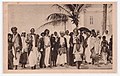 Notables belong to the Biimaal clan.jpg 1,722 × 1,086; 184 KB
-
 Qoryooley District.png 234 × 250; 16 KB
-
 Qoryooley.jpg 1,024 × 768; 422 KB
-
 Sablale District.png 234 × 250; 16 KB
-
 Shabeellaha Hoose, Somalia.svg 1,000 × 1,318; 11 KB
-
 Walls of Merca.png 806 × 587; 387 KB


.jpg)
.jpg)
.jpg)
.jpg)
.jpg)
.jpg)
.jpg)
.jpg)
.jpg)
.jpg)
.jpg)
.jpg)
.jpg)
.jpg)
.jpg)
.jpg)
.jpg)
.jpg)
.jpg)
.jpg)
.jpg)
.jpg)
.jpg)
.jpg)
.jpg)
.jpg)
.jpg)
.jpg)
.jpg)
.jpg)
.jpg)
.jpg)
.jpg)
.jpg)
.jpg)
.jpg)
.jpg)
.jpg)
.jpg)
.jpg)
.jpg)
.jpg)
.jpg)
.jpg)
.jpg)
.jpg)
.jpg)
.jpg)
.jpg)
.jpg)
.jpg)
.jpg)
.jpg)
.jpg)
.jpg)
.jpg)
.jpg)
.jpg)
.jpg)
.jpg)
.jpg)
.jpg)
.jpg)
.jpg)
.jpg)
.jpg)
.jpg)
.jpg)
.jpg)
.jpg)
.jpg)
.jpg)
.jpg)
.jpg)
.jpg)
.jpg)
.jpg)
.jpg)
.jpg)
.jpg)
.jpg)
.jpg)
.jpg)
.jpg)
.jpg)
.jpg)
.jpg)
.jpg)
.jpg)
.jpg)
.jpg)
.jpg)


