Category:Low tide in Vale of Glamorgan
Jump to navigation
Jump to search
Media in category "Low tide in Vale of Glamorgan"
The following 37 files are in this category, out of 37 total.
-
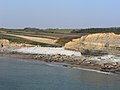 'Beach' and cliffs, Dunraven Bay. - geograph.org.uk - 1213766.jpg 640 × 480; 84 KB
-
-
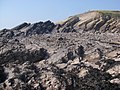
 Ancient Flying Saucer buried at Cwm Nash - geograph.org.uk - 1324110.jpg 2,848 × 2,136; 4.06 MB
-
-
 Black Rocks - geograph.org.uk - 209370.jpg 640 × 480; 124 KB
-
 Bwlch Gwyn looking inland - geograph.org.uk - 209382.jpg 640 × 480; 136 KB
-
 Cardiff Bay barrage - geograph.org.uk - 1377340.jpg 640 × 480; 88 KB
-

-
 Cold Knap Beach at low tide 2024-03-11.png 2,739 × 2,050; 7.84 MB
-
 Cold Knap Point - geograph.org.uk - 982083.jpg 640 × 480; 123 KB
-
 Limpert Bay - geograph.org.uk - 295435.jpg 640 × 480; 155 KB
-
 Looking along Ogmore Beach towards SE - geograph.org.uk - 209421.jpg 640 × 480; 103 KB
-

-
 Low spring tide view to Penarth Pier - geograph.org.uk - 1540062.jpg 640 × 480; 95 KB
-
 Low sun, low tide - geograph.org.uk - 545342.jpg 640 × 480; 80 KB
-
 Marker Beacon off Cold Knap Point - geograph.org.uk - 982070.jpg 640 × 480; 100 KB
-
 Monknash beach tied out - panoramio - cowbridgeguide.co.uk (1).jpg 2,048 × 1,536; 635 KB
-
 Monknash beach tied out - panoramio - cowbridgeguide.co.uk (2).jpg 2,048 × 1,536; 669 KB
-
 Monknash beach tied out - panoramio - cowbridgeguide.co.uk (3).jpg 2,048 × 1,536; 750 KB
-
 Monknash beach tied out - panoramio - cowbridgeguide.co.uk.jpg 2,048 × 1,536; 1.06 MB
-
 Monknash beach tied out - panoramio.jpg 2,048 × 1,536; 887 KB
-
 Monknash beach tied out sun going down - panoramio.jpg 2,048 × 1,536; 646 KB
-
 Monknash beach tied out there is sand and not just rocks - panoramio.jpg 2,048 × 1,536; 771 KB
-
 Ogmore River Mouth - geograph.org.uk - 184335.jpg 640 × 480; 114 KB
-
 Penarth Pier - a view at low tide.jpg 640 × 480; 87 KB
-
 Ranny Point at low tide - geograph.org.uk - 906360.jpg 640 × 480; 116 KB
-
 St. Mary's Well Bay - geograph.org.uk - 221442.jpg 640 × 480; 84 KB
-
 Sully Bay - geograph.org.uk - 975235.jpg 640 × 480; 102 KB
-
 Sully Bay Foreshore - geograph.org.uk - 976388.jpg 640 × 480; 125 KB
-
 Sully Sound at Low Tide - geograph.org.uk - 975146.jpg 640 × 480; 125 KB
-
 The coast towards Pigeon Point - geograph.org.uk - 89750.jpg 640 × 480; 102 KB
-
 The End of the Pier - geograph.org.uk - 836767.jpg 640 × 480; 98 KB
-

-
 Traeth Bach - geograph.org.uk - 1189740.jpg 640 × 498; 118 KB
-
 Traeth Mawr - geograph.org.uk - 1189576.jpg 640 × 618; 143 KB
-
 Traeth Mawr at low tide - geograph.org.uk - 161864.jpg 640 × 480; 65 KB
-
 Watch Tower bay - Barry Harbour - geograph.org.uk - 272834.jpg 640 × 438; 108 KB


.jpg)
.jpg)
.jpg)


