Category:Linguistic maps of the Welsh language
Jump to navigation
Jump to search
Subcategories
This category has the following 2 subcategories, out of 2 total.
Media in category "Linguistic maps of the Welsh language"
The following 11 files are in this category, out of 11 total.
-
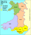 Dialectos galés.png 471 × 537; 9 KB
-
 LandskerMap1901.jpg 2,000 × 2,000; 282 KB
-
 Map o ieithoedd Cymru (A map of the languages of Wales) - 1750.svg 611 × 707; 35 KB
-
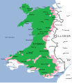 Map o ieithoedd Cymru (A map of the languages of Wales) - 1800.svg 611 × 707; 36 KB
-
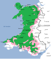 Map o ieithoedd Cymru (A map of the languages of Wales) - 1850.svg 611 × 707; 38 KB
-
 Map o ieithoedd Cymru (A map of the languages of Wales) - 1900.svg 611 × 707; 38 KB
-
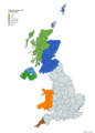 Minority languages of the United Kingdom.png 4,765 × 6,618; 2.05 MB
-
 Southall's census map of Wales.jpg 1,046 × 1,500; 555 KB
-
 Welsh speakers in the 2011 census Pembrokeshire.png 13,342 × 14,791; 4.62 MB
-
 Welsh speakers in the 2011 census.png 13,342 × 14,791; 11.63 MB
-
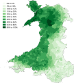
 Welsh speakers in the 2021 census.svg 512 × 561; 427 KB


_-_1750.svg)
_-_1800.svg)
_-_1850.svg)
_-_1900.svg)


