Category:Leventina
Jump to navigation
Jump to search

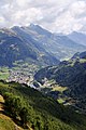
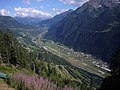
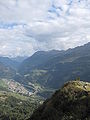
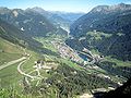
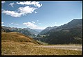
Deutsch: Die Valle Leventina deutsch meist kurz Leventina, veraltet Livinental) ist ein Tal im Kanton Tessin in der Schweiz. Die Leventina wird vom Ticino durchflossen und erstreckt sich von Airolo am Südende des Gotthardpasses bis nach Biasca. Zusammen mit dem Val Bedretto im Westen bildet sie den Distretto di Leventina (Bezirk Leventina). Das Tal liegt auf einer auf europäisch wichtigen Nord - Südachse. Der Gotthardpass am oberen Ende der Leventina beeinflusste die Geschichte des Tales durch die Jahrhunderte. Durch die Leventina führte früher die alte Gotthardstrasse, später die Gotthardbahn und dann die Autobahn A2, welche Chiasso mit Basel verbindet. In Bodio liegt das Südportal des zukünftigen längsten Eisenbahntunnels der Welt (NEAT). Die Leventina hat zahlreiche Seitentäler. Die wichtigsten sind das Val Piumogna bei Dalpe, das Val Chironico bei Chironico und das Val d'Ambra bei Personico auf der rechten Seite, sowie das Val Canaria bei Airolo und das Val Piora oberhalb von Piotta auf der linken Seite. Im Val Piora befinden sich der Stausee Lago Ritom und der bei Biologen wohl bekannte Lago di Cadagno. Das Tal ist durch Schluchten in drei Teilen unterteilt: Alta Leventina, Media Leventina und Bassa Leventina.
Gemeinden des Distretto di Leventina (Stand April 2009): Airolo, Bedretto, Anzonico, Bodio, Cavagnago, Giornico, Personico, Pollegio, Sobrio, Calpiogna, Campello, Chironico, Faido, Mairengo, Osco, Dalpe, Prato und Quinto.
Gemeinden des Distretto di Leventina (Stand April 2009): Airolo, Bedretto, Anzonico, Bodio, Cavagnago, Giornico, Personico, Pollegio, Sobrio, Calpiogna, Campello, Chironico, Faido, Mairengo, Osco, Dalpe, Prato und Quinto.

valley  | |||||
| Upload media | |||||
| Instance of | |||||
|---|---|---|---|---|---|
| Location | Ticino, Switzerland | ||||
| Located in or next to body of water | |||||
| Mountain range | |||||
| Elevation above sea level |
| ||||
 | |||||
Subcategories
This category has the following 39 subcategories, out of 39 total.
B
C
- Cavagnago (4 F)
D
F
G
I
L
M
- Mairengo (7 F)
- Minerals of Campolungo (4 F)
- Minerals of Scimfuss (5 F)
- Minerals of Tremola Valley (1 F)
O
- Osco (8 F)
P
Q
R
S
T
V
Media in category "Leventina"
The following 48 files are in this category, out of 48 total.
-
 1252 Ambrì-Piotta.jpg 14,000 × 9,600; 134.32 MB
-
 Airlonia2.jpg 1,126 × 1,690; 404 KB
-
 Airolo 1.jpg 3,000 × 2,000; 2.5 MB
-
 Airolo Gotthard.jpg 2,272 × 1,704; 1.94 MB
-
 Alpe di Piora Leventina.jpg 4,608 × 2,592; 3.5 MB
-
 Ambri Airfield Ritom.JPG 2,816 × 2,112; 2.62 MB
-
 C 0089c 0054 - Blick von der Gotthardstrasse auf Airolo und Leventina.tif 3,175 × 3,198; 38.74 MB
-
 Cadagno di Fuori Val Piora.jpg 4,608 × 2,592; 5.52 MB
-
 CH-NB Photoglob-Wehrli EAD-WEHR-32130-B.tiff 4,781 × 3,670; 16.77 MB
-
 Die Gartenlaube (1899) b 0861.jpg 2,642 × 3,814; 1.42 MB
-
 ETH-BIB-Gotthard, Blick nach Südsüdosten, Valle Leventina-LBS H1-009186.tif 6,427 × 4,395; 80.96 MB
-
 ETH-BIB-Valle Leventina, Blick nach Südosten, Pizo di Claro-LBS H1-027318.tif 8,445 × 5,906; 142.75 MB
-
 ETH-BIB-Valle Leventina, Blick nach Westen, Pizzo Lei di Cima-LBS H1-016384-AL.tif 6,580 × 4,676; 88.18 MB
-
 ETH-BIB-Valle Leventina, Blick Ostsüdosten Piz di Strega-LBS H1-027312.tif 8,392 × 5,940; 142.66 MB
-
 ETH-BIB-Valle Leventina, Blick Ostsüdosten Rheinwaldhorn-LBS H1-027314.tif 8,564 × 5,925; 145.22 MB
-
 ETH-BIB-Valle Leventina, Blick SE Pizzo di Claro-LBS H1-027315.tif 8,463 × 5,921; 143.41 MB
-
 ETH-BIB-Valle Leventina, Blick Südosten Piz di Strega-LBS H1-027313.tif 8,589 × 5,900; 145.02 MB
-
 ETH-BIB-Valle Leventina, Blick Südosten Piz di Strega-LBS H1-027317.tif 8,553 × 5,958; 145.85 MB
-
 ETH-BIB-Valle Leventina, Blick Südwesten Campo Tencia-LBS H1-016398.tif 6,739 × 4,726; 91.3 MB
-
 Flugzeuge C-35 über Lumino - San Vittore Dia 342-003.jpg 5,387 × 3,498; 4.49 MB
-
 Gotthard Pass 001-Gotthard Pass 003.jpg 3,476 × 1,808; 1.16 MB
-
 Gotthard Pass 003.JPG 2,112 × 2,816; 1.64 MB
-
 Gotthard Südrampe.jpg 1,000 × 750; 117 KB
-
 Gotthard-Leventina 02.JPG 2,230 × 1,603; 847 KB
-
 ISS006-E-44355 - View of Switzerland.jpg 3,032 × 2,064; 1.68 MB
-
 ISS006-E-44357 - View of Switzerland.jpg 3,032 × 2,064; 1.54 MB
-
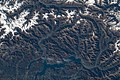 ISS061-E-13444 - View of Earth.jpg 5,568 × 3,712; 3.21 MB
-
 Karte Bezirk Leventina 2007 blank.png 2,066 × 1,353; 580 KB
-
 Karte Bezirk Leventina 2007.png 2,066 × 1,353; 792 KB
-
 Karte Bezirk Leventina.png 649 × 1,029; 214 KB
-
 Karte Gemeinden des Bezirks Leventina 2006.png 1,181 × 897; 230 KB
-
 Lago Cadagno See Val Piora.jpg 4,608 × 2,592; 4.23 MB
-
 Lago Ritom See Leventina.jpg 4,608 × 2,592; 3.1 MB
-
 Lago Ritom See Val Piora 2015-08-31.jpg 4,608 × 2,592; 3.29 MB
-
 Leventina.jpg 1,690 × 1,126; 155 KB
-
 Leventina01.JPG 1,210 × 1,058; 450 KB
-
 Passo San Gottardo Versante Sud.jpg 3,008 × 2,000; 1.96 MB
-
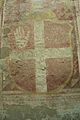 Pellegrino Wappen1.jpg 3,456 × 5,184; 5.96 MB
-
 Ritom 21.06.08 025.jpg 2,048 × 1,536; 312 KB
-
 SUI 1934 MiNr0274 pm B002a.jpg 724 × 843; 306 KB
-
 Ti bez leventina.png 160 × 270; 4 KB
-
 Valle Leventina & Airolo.jpg 8,688 × 5,430; 38.89 MB
-
 Valle Leventina.jpg 2,592 × 1,944; 535 KB
-
 Veduta dei contrafforti sud-occidentali del Pizzo Canariscio.jpg 2,030 × 3,000; 1.2 MB
-
 Veduta della Valle Leventina (DOI 25714).jpg 3,000 × 2,014; 1,016 KB
-
 Veduta della Valle Leventina e dell'aeroporto militare di Ambri.jpg 2,037 × 3,000; 707 KB
-
 Veduta della Valle Leventina.jpg 3,000 × 2,040; 750 KB
-
 Veduta di Airolo dal Punto panoramico San Gottardo.jpg 2,023 × 3,000; 1.27 MB


_b_0861.jpg)


.jpg)


