Category:Leeuwte 51, Sint Jansklooster
Jump to navigation
Jump to search
| Object location | | View all coordinates using: OpenStreetMap |
|---|
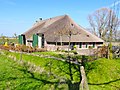
farmhouse in Steenwijkerland, Netherlands  | |||||
| Upload media | |||||
| Instance of | |||||
|---|---|---|---|---|---|
| Location | Sint Jansklooster, Steenwijkerland, Overijssel, Netherlands | ||||
| Street address |
| ||||
| Heritage designation |
| ||||
 | |||||
|
This is a category about rijksmonument number 10580
|
| Address |
|
Media in category "Leeuwte 51, Sint Jansklooster"
The following 23 files are in this category, out of 23 total.
-
 Boerderij Leeuwte.jpg 1,824 × 1,368; 422 KB
-
 Exterieur - Vollenhove - 20245202 - RCE.jpg 1,200 × 796; 166 KB
-
 Gedeelte rechter zijgevel, met brede inrit tot de deel - Leeuwte - 20332604 - RCE.jpg 1,189 × 1,200; 408 KB
-
 Interieur gang, overzicht wandbetimmering - Leeuwte - 20332609 - RCE.jpg 1,189 × 1,200; 167 KB
-
 Interieur kelder met trapopgang - Leeuwte - 20332612 - RCE.jpg 1,186 × 1,200; 198 KB
-
 Interieur overzicht kelder - Leeuwte - 20332613 - RCE.jpg 1,188 × 1,200; 232 KB
-
 Interieur overzicht schuur - Leeuwte - 20332614 - RCE.jpg 1,186 × 1,200; 337 KB
-
 Interieur schuur, overzicht gebinten - Leeuwte - 20332615 - RCE.jpg 1,182 × 1,200; 366 KB
-
 Interieur schuur, overzicht gebinten - Leeuwte - 20332616 - RCE.jpg 1,188 × 1,200; 310 KB
-
 Interieur voorhuis, overzicht woonkamer - Leeuwte - 20332610 - RCE.jpg 1,182 × 1,200; 191 KB
-
 Interieur voorkamer met bedstedewand - Leeuwte - 20332611 - RCE.jpg 1,189 × 1,200; 206 KB
-
 Linker zijgevel - Leeuwte - 20332606 - RCE.jpg 1,191 × 1,200; 440 KB
-
 Overzicht achtergevel - Leeuwte - 20332608 - RCE.jpg 1,192 × 1,200; 339 KB
-

-
 Overzicht exterieur - Vollenhove - 20245200 - RCE.jpg 1,200 × 803; 252 KB
-
 Overzicht linker zijgevel en achtergevel - Leeuwte - 20332607 - RCE.jpg 1,187 × 1,200; 363 KB
-
 Overzicht rechter zijgevel - Leeuwte - 20332603 - RCE.jpg 1,188 × 1,200; 355 KB
-
 Overzicht voorgevel - Leeuwte - 20332602 - RCE.jpg 1,182 × 1,200; 417 KB
-

-
 Rechter zijgevel - Leeuwte - 20332605 - RCE.jpg 1,185 × 1,200; 320 KB
-
 Voorgevel - Vollenhove - 20245201 - RCE.jpg 1,200 × 808; 192 KB
-
 Zijgevel nr. Grote Leeuwte 12 - Groote Leeuwte - 20469817 - RCE.jpg 1,200 × 900; 177 KB
-
 Zijgevel nr. Grote Leeuwte 9 - Groote Leeuwte - 20469818 - RCE.jpg 934 × 891; 146 KB


