Category:Lavender Open Pit Mine
Jump to navigation
Jump to search
| Object location | | View all coordinates using: OpenStreetMap |
|---|
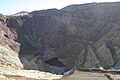
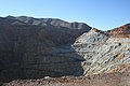
Former copper mine in Cochise County, Arizona  | |||||
| Upload media | |||||
| Instance of | |||||
|---|---|---|---|---|---|
| Location | Arizona | ||||
| Operator | |||||
| Elevation above sea level |
| ||||
| Drainage basin |
| ||||
 | |||||
English: Locality: Lavender Open Pit Mine (Lavender pit), Bisbee, Warren District, Mule Mts, Cochise County, Arizona, USA (Locality at mindat.org)
Deutsch: Fundort: Lavender Open Pit Mine (Lavender pit), Bisbee, Warren District, Mule Mts, Cochise County, Arizona, Vereinigte Staaten (Fundort bei mindat.org)
Subcategories
This category has only the following subcategory.
Media in category "Lavender Open Pit Mine"
The following 35 files are in this category, out of 35 total.
-
 2016 Arizona Bisbee Lavender Mine.jpg 4,032 × 3,024; 4.65 MB
-
 Anaconda Copper Mining Co.'s open mine pit at Bisbee, Arizona.jpg 600 × 814; 357 KB
-
 Antlerite-177362.jpg 600 × 394; 95 KB
-
 Antlerite-177363.jpg 572 × 584; 143 KB
-
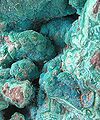
 Azurite-Malachite-167914.jpg 278 × 449; 38 KB
-
 Azurite-Malachite-169726.jpg 451 × 600; 94 KB
-
 Bisbee Arizona March 1996 - Mine pit.jpg 3,877 × 5,770; 15.59 MB
-
 Bisbee Arizona March 1996 - Mine.jpg 3,905 × 5,786; 8.06 MB
-
 Bisbee Lavender Mine 1.jpg 5,964 × 3,608; 19.26 MB
-
 Bisbee Lavender Mine 2.jpg 6,749 × 3,253; 20.33 MB
-
 Bisbee Mine - panoramio.jpg 3,888 × 2,592; 3.47 MB
-
 Bisbee mine - panoramio.jpg 3,888 × 2,592; 4.21 MB
-
 Bisbee-The Lavender Pit-1.jpg 4,608 × 3,456; 6 MB
-
 Bisbee-The Lavender Pit-2.jpg 4,608 × 3,456; 3.78 MB
-
 Bisbee-The Lavender Pit-3.jpg 2,409 × 1,945; 1.33 MB
-
 Bornite-169713.jpg 600 × 423; 104 KB
-
 Brochantite-163973.jpg 524 × 600; 97 KB
-
 Chrysocolla-136124.jpg 600 × 479; 108 KB
-
 Chrysocolla-136125.jpg 333 × 400; 60 KB
-
 Copper mining town, Bisbee, Arizona, ca.1900 (CHS-4616).jpg 4,792 × 3,718; 806 KB
-
 Copper mining town, Bisbee, Arizona, ca.1900 (CHS-4758).jpg 5,065 × 3,913; 1.46 MB
-
 Lavender Pit (8042367192) (2).jpg 4,256 × 2,832; 4.62 MB
-
 Lavender Pit Bisbee AZ.jpg 1,024 × 680; 679 KB
-
 Looking into the Lavender Pit. The Lavender Open Pit Mine, Bisbee, Arizona.jpg 4,672 × 3,104; 8.54 MB
-
 Malachite-158647.jpg 500 × 508; 69 KB
-
 Malachite-Azurite-Goethite-230493.jpg 600 × 464; 74 KB
-
 PHELPS DODGE CORP.'S LAVENDER PIT MINE - NARA - 544106.jpg 3,000 × 2,027; 1.49 MB
-
 PHELPS DODGE CORP.'S LAVENDER PIT MINE - NARA - 544107.jpg 3,000 × 2,024; 1.38 MB
-
 PHELPS LODGE CORP.'S ABANDONED MINE TOWER AT THE LAVENDER PIT MINE - NARA - 544102.jpg 2,029 × 3,000; 1.72 MB
-
 Purple Heart county sign on fence.jpg 3,200 × 2,368; 3.53 MB
-
 Southern Pacific GP9 (16107929300).jpg 2,099 × 1,392; 2.64 MB
-
 The Lavender Open Pit Mine, Bisbee, Arizona.jpg 3,264 × 2,448; 4.75 MB
-
 The Lavender Pit, Bisbee, AZ.jpg 1,200 × 1,600; 686 KB
-
 THE PHELPS DODGE CORP.'S LAVENDER PIT MINE - NARA - 544110.jpg 2,018 × 3,000; 1.38 MB
-
 THE PHELPS DODGE CORP.'S LAVENDER PIT MINE - NARA - 544111.jpg 3,000 × 2,015; 1.32 MB


.jpg)
.jpg)
_(2).jpg)


.jpg)


