Category:Latteridge
Jump to navigation
Jump to search
village in the United Kingdom | |||||
| Upload media | |||||
| Instance of | |||||
|---|---|---|---|---|---|
| Location | South Gloucestershire, Gloucestershire, South West England, England | ||||
 | |||||
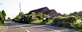
English: Latteridge is a hamlet in South Gloucestershire, England, on the B4059 road north of Iron Acton, and south of Rudgeway and Earthcott. The hamlet is divided by the busy B4059, there is a large village green, a railway crossing, a large duck pond and a ruined church.
Bahasa Indonesia: Latteridge adalah sebuah hamlet (desa) di South Gloucestershire, Inggris, terletak di jalan B4059 di utara Iron Acton, dan selatan Rudgeway dan Earthcott. Hamlet ini dibelah oleh jalan B4059, terdapat sebuah taman desa besar, rel kereta, kolam bebek besar dan gereja tak terpakai. Tidak ada acara yang diselenggarkan di sana saat ini.
Media in category "Latteridge"
The following 7 files are in this category, out of 7 total.
-

-
 Latteridge - geograph.org.uk - 33328.jpg 640 × 480; 62 KB
-
 Mirrors on the roadside. - geograph.org.uk - 552916.jpg 640 × 250; 62 KB
-
 Sheep and substation - geograph.org.uk - 489719.jpg 640 × 480; 73 KB
-
 Fields and Pylons - geograph.org.uk - 376835.jpg 640 × 480; 76 KB
-
 Muddy gateway - geograph.org.uk - 382419.jpg 640 × 480; 96 KB
-
 Ruin at Lark's Farm - geograph.org.uk - 382414.jpg 640 × 480; 88 KB


