Category:Lathbury
Jump to navigation
Jump to search
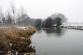
English: Lathbury is a village and civil parish in the Borough of Milton Keynes and ceremonial Buckinghamshire, England. It is just to the north of Newport Pagnell.
Norsk bokmål: Lathbury er en landsby og et verdslig sogn i Milton Keynes i England. Stedet ligger like nord for Newport Pagnell.
village and civil parish in Buckinghamshire, United Kingdom  | |||||
| Upload media | |||||
| Instance of | |||||
|---|---|---|---|---|---|
| Location | City of Milton Keynes, Buckinghamshire, South East England, England | ||||
 | |||||
Subcategories
This category has only the following subcategory.
A
- All Saints Church, Lathbury (6 F)
Media in category "Lathbury"
The following 43 files are in this category, out of 43 total.
-
 All Saints Church at Lathbury - geograph.org.uk - 3295659.jpg 1,600 × 1,067; 495 KB
-
 B526 Northampton Road at North Bridge - geograph.org.uk - 3185954.jpg 3,072 × 2,304; 1.38 MB
-
 B526 Northampton Road at North Bridge - geograph.org.uk - 3185965.jpg 3,072 × 2,304; 1.29 MB
-
 B526, Northampton Road, Newport Pagnell - geograph.org.uk - 3185977.jpg 3,072 × 2,304; 1.23 MB
-
 Bridge over the Great Ouse - geograph.org.uk - 3295672.jpg 1,600 × 1,066; 542 KB
-
 Conifers on Northampton Road, Lathbury - geograph.org.uk - 5401641.jpg 1,990 × 1,454; 1.2 MB
-
 Farm Road near Tyringham - geograph.org.uk - 195371.jpg 640 × 480; 72 KB
-
 Farm track to Northampton Road - geograph.org.uk - 3295674.jpg 1,600 × 1,072; 355 KB
-
 Fields next to the River Great Ouse - geograph.org.uk - 3185959.jpg 3,072 × 2,304; 1.3 MB
-
 Footpath from Lathbury - geograph.org.uk - 3295650.jpg 1,600 × 1,065; 552 KB
-
 Footpath into Lathbury - geograph.org.uk - 3295654.jpg 1,200 × 1,600; 562 KB
-
 Footpath to Lathbury - geograph.org.uk - 3295616.jpg 1,600 × 1,067; 526 KB
-
 Great Ouse by Lathbury - geograph.org.uk - 3295644.jpg 1,600 × 1,067; 395 KB
-
 Great Ouse in flood - geograph.org.uk - 3248457.jpg 3,264 × 2,448; 1.73 MB
-
 Great Ouse toward Sherington - geograph.org.uk - 3295668.jpg 1,600 × 1,066; 351 KB
-
 Lathbury - North Bucks - geograph.org.uk - 195369.jpg 640 × 480; 100 KB
-
 Lathbury bridge over the Great Ouse floodplain - geograph.org.uk - 2926716.jpg 1,694 × 1,127; 1.04 MB
-
 Lathbury Church - geograph.org.uk - 2131849.jpg 1,600 × 1,200; 430 KB
-
 Lathbury Manor care home - geograph.org.uk - 5401638.jpg 2,048 × 1,536; 1.43 MB
-
 Lathbury Manor, Lathbury (geograph 4160449).jpg 640 × 487; 163 KB
-
 Lathbury, All Saints - geograph.org.uk - 5441453.jpg 4,608 × 3,456; 3.97 MB
-
 North Bridge, Newport Pagnell - geograph.org.uk - 4922858.jpg 1,280 × 851; 288 KB
-
 Northampton Road, Lathbury - geograph.org.uk - 3074235.jpg 1,600 × 1,200; 496 KB
-
 Northampton Road, Lathbury - geograph.org.uk - 5401640.jpg 2,048 × 1,536; 1.42 MB
-
 Northampton Road, Lathbury - geograph.org.uk - 5402010.jpg 2,048 × 1,536; 967 KB
-
 Northampton Road, Lathbury - geograph.org.uk - 5422524.jpg 2,048 × 1,536; 895 KB
-

-

-
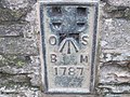 Ordnance Survey Flush Bracket 1787 - geograph.org.uk - 3250767.jpg 3,264 × 2,448; 2.15 MB
-
 Path to Northampton Road - geograph.org.uk - 3295664.jpg 1,600 × 1,067; 590 KB
-
 Path toward Quarry Hall Farm - geograph.org.uk - 3295632.jpg 1,600 × 1,068; 534 KB
-
 Path toward Quarry Hall Farm - geograph.org.uk - 3295647.jpg 1,600 × 1,067; 472 KB
-
 River Bank, the Ouse - geograph.org.uk - 492879.jpg 604 × 453; 59 KB
-
 Sherington Bridge - geograph.org.uk - 492871.jpg 604 × 453; 52 KB
-
 Sherington Road - Newport Pagnell - geograph.org.uk - 195363.jpg 480 × 640; 103 KB
-
 Sherington Road, Newport Pagnell - geograph.org.uk - 3185994.jpg 3,072 × 2,304; 1.4 MB
-
 Small brook by the Great Ouse - geograph.org.uk - 3295624.jpg 1,600 × 1,067; 707 KB
-
 The Great Ouse looking West - geograph.org.uk - 3295640.jpg 1,600 × 1,067; 397 KB
-
 The road to Quarry Hall Farm - geograph.org.uk - 3295614.jpg 1,600 × 1,067; 470 KB
-
 Toll House, North Bridge - geograph.org.uk - 4924356.jpg 1,280 × 851; 431 KB
-
 Tree on the B526, Lathbury - geograph.org.uk - 5401639.jpg 2,048 × 1,536; 1.57 MB
-
 Tree-lined drive to Quarry Hill Farm - geograph.org.uk - 195370.jpg 640 × 480; 114 KB
-
 Trees on the A546, Tyringham - geograph.org.uk - 5421490.jpg 1,536 × 2,048; 1.43 MB


.jpg)


