Category:Langgasse 134/136 (Haßloch)
Jump to navigation
Jump to search
| Object location | | View all coordinates using: OpenStreetMap |
|---|

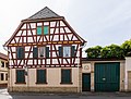
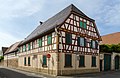
Langgasse 134/136 former inn "Zum Weißen Ross"
- U-shaped farm, 18th century
- Two large-volume residential buildings, half hipped roof buildings, partly timber framing, No. 136 designated 1762, No. 134 designated 1765, two gateways, farm buildings with half-timbered structures, garden pavilion around 1900
- streetscape formative
Media in category "Langgasse 134/136 (Haßloch)"
The following 2 files are in this category, out of 2 total.
-
 022 2015 08 27 Kulturdenkmaeler Hassloch.jpg 2,562 × 1,951; 2.5 MB
-
 023 2015 08 27 Kulturdenkmaeler Hassloch.jpg 2,778 × 1,800; 2.88 MB

