Category:Landslides caused by the 2011 Canterbury earthquake
Jump to navigation
Jump to search
Media in category "Landslides caused by the 2011 Canterbury earthquake"
The following 18 files are in this category, out of 18 total.
-
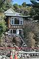
 54 Raekura Place, Redcliffs.JPG 4,000 × 3,000; 4.39 MB
-
 Aerial photo of damage to Christchurch - Flickr - NZ Defence Force.jpg 1,321 × 874; 452 KB
-
 Cass Peak 213.JPG 5,472 × 3,648; 3.63 MB
-
 Cass Peak 214.JPG 5,472 × 3,648; 6.1 MB
-
 Crater Rim walkway 212.JPG 5,472 × 3,648; 4.87 MB
-
 Earthquake Damage at Sumner Coast - Flickr - NZ Defence Force.jpg 1,321 × 874; 440 KB
-
 Earthquake damage to stately home in Redclifts - panoramio.jpg 1,880 × 2,816; 2.59 MB
-
 Mount Vernon Park track 47.JPG 4,000 × 3,000; 4.08 MB
-
 Mount Vernon Park track 48.JPG 4,000 × 3,000; 4.34 MB
-
 Peacock's Gallop, Sumner.JPG 3,000 × 4,000; 3.82 MB
-
 Port Hills 102.JPG 3,264 × 2,448; 2.08 MB
-
 Port Hills 104.JPG 3,264 × 2,448; 2.32 MB
-
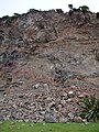
 Redcliffs landslide1.JPG 4,000 × 3,000; 4.18 MB
-
 Summit Road 063.JPG 2,448 × 3,264; 4.08 MB
-
 Summit Road 58.JPG 4,000 × 3,000; 4.09 MB
-
 Summit Road 61.JPG 4,000 × 3,000; 4.3 MB
-
 Summit Road 64.JPG 4,000 × 3,000; 4.24 MB
-
 Summit Road 67.JPG 4,000 × 3,000; 4.21 MB


