Category:Lage Gouwe 116-118-118a & 120-122 & 124-126
Jump to navigation
Jump to search
| Object location | | View all coordinates using: OpenStreetMap |
|---|
|
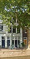
This is a category about a municipal monument in Gouda with number 512 |
Subcategories
This category has only the following subcategory.
L
Media in category "Lage Gouwe 116-118-118a & 120-122 & 124-126"
This category contains only the following file.
-
 Lage Gouwe 116, 118, Gouda.jpg 2,048 × 3,982; 5.56 MB
