Category:La Roche-aux-Fées
Jump to navigation
Jump to search
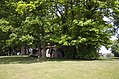
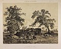
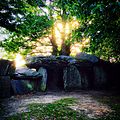
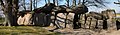
Français : La Roche-aux-Fées est un monument mégalithique (allée couverte) situé à Essé en Ille-et-Vilaine, Bretagne, France.
Brezhoneg: Maen ar Boudiged gouez da dud zo, zo ul liac'hven en Ezieg, e gevred Bro-Roazhon.
Deutsch: La Roche-aux-Fées in der Gemeinde Essé, zwischen Vitré und Châteaubriant in der Bretagne gelegen, ist ein Dolmen in Frankreich.
Euskara: La Roche-aux-Fées Bretainiako Ille-et-Vilaine departamentuan eta Bro-Roazhon eskualde historikoan dagoen monumentu megalitikoa da.
|
This building is classé au titre des monuments historiques de la France. It is indexed in the base Mérimée, a database of architectural heritage maintained by the French Ministry of Culture, under the references PA00090553
|
| Object location | | View all coordinates using: OpenStreetMap |
|---|
gallery grave in Essé, France  .JPG)  | |||||
| Upload media | |||||
| Instance of | |||||
|---|---|---|---|---|---|
| Location | Essé, canton of Retiers | ||||
| Heritage designation |
| ||||
| Elevation above sea level |
| ||||
 | |||||
Media in category "La Roche-aux-Fées"
The following 46 files are in this category, out of 46 total.
-

-
 Bézier - La Roche-aux-Fées, ouest.png 2,481 × 1,749; 202 KB
-
 Bézier - La Roche-aux-Fées, sud.png 2,481 × 1,749; 185 KB
-
 Bézier - Plan de la roche-aux-fées.png 2,481 × 1,749; 119 KB
-
 Caylus - Roche aux fées (1756).png 813 × 1,184; 493 KB
-
 Distribució dòlmens angevins.png 495 × 467; 70 KB
-
 Dolmen-roche-aux-fees.jpg 2,048 × 1,536; 708 KB
-
 Essé-FR-35-dolmen de la Roche-aux-Fées-01.jpg 4,032 × 3,024; 4.13 MB
-
 Essé-FR-35-dolmen de la Roche-aux-Fées-02.jpg 4,032 × 3,024; 4.24 MB
-
 Essé-FR-35-dolmen de la Roche-aux-Fées-03.jpg 4,032 × 3,024; 4.09 MB
-
 Essé-FR-35-dolmen de la Roche-aux-Fées-04.jpg 4,032 × 3,024; 3.87 MB
-
 Essé-FR-35-dolmen de la Roche-aux-Fées-05.jpg 4,032 × 3,024; 3.46 MB
-
 Essé-FR-35-dolmen de la Roche-aux-Fées-06.jpg 4,032 × 3,024; 2.64 MB
-
 Essé-FR-35-dolmen de la Roche-aux-Fées-07.jpg 4,032 × 3,024; 2.87 MB
-
 Essé-FR-35-dolmen de la Roche-aux-Fées-08.jpg 4,032 × 3,024; 2.91 MB
-
 Essé-FR-35-dolmen de la Roche-aux-Fées-09.jpg 4,032 × 3,024; 2.82 MB
-
 EsséRoche 1.jpg 4,500 × 2,981; 12.58 MB
-
 EsséRoche 2.jpg 4,779 × 2,689; 10.73 MB
-
 EsséRoche 3.jpg 4,704 × 3,116; 13.51 MB
-
 Ille-Et-Vilaine Esse La Roche Aux Fees 111989 - panoramio (1).jpg 3,888 × 2,554; 1.13 MB
-
 Ille-Et-Vilaine Esse La Roche Aux Fees 111989 - panoramio.jpg 2,384 × 1,556; 1.16 MB
-
 Inscription Roche-aux-Fées.JPG 3,264 × 2,448; 2.45 MB
-
 La Roche aux fées - dessin Felix Benoist.jpeg 1,600 × 1,191; 853 KB
-
 La Roche aux Fées - La Bretagne contemporaine.jpg 1,742 × 1,402; 1.92 MB
-
 La Roche aux Fées dscf7439-7489.jpg 6,394 × 3,615; 21.11 MB
-
 La Roche Aux Fées.jpg 2,448 × 2,448; 3.44 MB
-
 La Roche aux Fées.jpg 1,649 × 1,083; 569 KB
-
 La Roche aux-Fées (Roca de les fades).png 805 × 537; 1.13 MB
-
 La Roche-aux-Fées (intérieur).JPG 3,264 × 2,448; 2.08 MB
-
 La Roche-aux-Fées (portique).jpg 3,264 × 2,448; 2.45 MB
-
 La Roche-aux-Fées (vue générale).JPG 3,264 × 2,448; 2.13 MB
-
 La Roche-aux-Fées - Essé 01.jpg 4,272 × 2,848; 6.43 MB
-
 La Roche-aux-Fées - Hercule Catenacci - Le Magasin pittoresque.jpg 2,500 × 1,847; 2.97 MB
-
 La Roche-aux-Fées - intérieur - Essé 01.jpg 4,272 × 2,848; 4.66 MB
-
 La Roche-aux-Fées Desmots.jpg 1,022 × 657; 424 KB
-
 La Roche-aux-Fées, Bretagne1986-133.jpg 5,389 × 3,160; 1.88 MB
-
 LaRocheAuxFees Dolmen 2 20070408.jpg 1,944 × 905; 436 KB
-
 LaRocheAuxFees Dolmen.jpg 2,898 × 854; 660 KB
-
 LaRocheAuxFees Interieur.jpg 1,944 × 1,296; 499 KB
-
 LaRocheAuxFees Portique.jpg 1,826 × 1,008; 451 KB
-
 Lemaire - Allée Couverte la Roche-aux-Fées - 1900-1920.jpg 685 × 512; 97 KB
-
 Roche-aux-Fees.svg 600 × 300; 10 KB
-
 Roche-aux-Fées (vue latérale, pierre couchée).jpg 3,264 × 2,448; 2.54 MB
-
 Roche-aux-fées1.jpg 2,000 × 1,333; 2.62 MB
-
 Roche-aux-fées2.jpg 2,000 × 1,333; 2.79 MB
-
 The Roche aux Fées.JPG 2,648 × 1,912; 1.03 MB


.png)


.jpg)


.png)
.jpg)
.JPG)


.jpg)


