Category:La Costa Xeric Shrublands Ecoregion
Jump to navigation
Jump to search
| Upload media | |||||
| Instance of | |||||
|---|---|---|---|---|---|
| Location |
| ||||
 | |||||
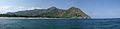
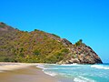
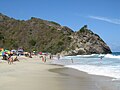
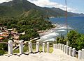
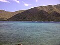
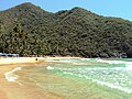
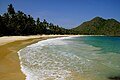
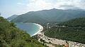
The La Costa Xeric Shrublands Ecoregion is a designated ecoregion by WWF and One Earth. It is classified as a Deserts & Xeric Shrublands Biome. It is one of 12 ecoregions in the Venezuelan Coast Bioregion.
Subcategories
This category has only the following subcategory.
M
Media in category "La Costa Xeric Shrublands Ecoregion"
The following 39 files are in this category, out of 39 total.
-
 12540824 10153145482151862 2934527777716422134 n 02.jpg 720 × 540; 83 KB
-
 12540824 10153145482151862 2934527777716422134 n 06.jpg 720 × 540; 146 KB
-
 Acercándose al Paraíso.JPG 4,608 × 3,456; 8.9 MB
-
 Al otro lado de Cuyagua.jpg 720 × 540; 106 KB
-
 AngelHernandez Paisaje 4.JPG 3,664 × 2,748; 2 MB
-
 Catica, Bahía de Cata.JPG 4,608 × 3,456; 6.34 MB
-
 Cerro el Macaro estado Aragua. Venezuela.jpg 2,048 × 1,536; 1.09 MB
-
 Cerro Hotel Maracay y Cordillera de la Costa.jpg 3,648 × 2,736; 4.74 MB
-
 CHORONI ESTADO ARAGUA 01.JPG 3,648 × 2,736; 7.19 MB
-
 CHORONI ESTADO ARAGUA 03.JPG 3,648 × 2,736; 7.18 MB
-
 CHORONI ESTADO ARAGUA 04.JPG 3,648 × 2,736; 7.2 MB
-
 CHORONI, EDO. ARAGUA.jpg 2,592 × 1,944; 507 KB
-
 CHORONI-CHORONI.JPG 3,264 × 2,448; 3.94 MB
-
 Chuao, costa oeste.jpg 4,992 × 1,216; 2.13 MB
-
 Coragyps atratus 1.jpg 3,648 × 2,736; 1.34 MB
-
 Cuyagua 001.jpg 960 × 720; 105 KB
-
 Cuyagua.jpg 1,600 × 1,200; 287 KB
-
 Desde Via de Cuyagua, Panoramica de Bahia de Cata.JPG 5,456 × 3,632; 6.22 MB
-
 El Mar de Ocumare.jpg 3,072 × 2,304; 2.53 MB
-
 El Playón Ocumare de la Costa.jpg 3,422 × 1,606; 4.12 MB
-
 Escalinatas de Mirador de Choroni Edo. Aragua.JPG 3,398 × 2,502; 4.02 MB
-
 La Cienaga de Ocumare Aragua - Venezuela 005.jpg 960 × 720; 114 KB
-
 La Cienaga de Ocumare Aragua - Venezuela 011.jpg 960 × 720; 106 KB
-
 La Cienaga de Ocumare Aragua - Venezuela 017.jpg 960 × 720; 108 KB
-
 La Cienaga.JPG 2,816 × 2,112; 2.2 MB
-
 Laguna de la Cienaga.JPG 2,816 × 1,872; 2.34 MB
-
 Manglares.JPG 2,816 × 1,872; 2.49 MB
-
 Paisaje de El Playón.jpg 3,072 × 2,304; 3.37 MB
-
 Parque nacional Henri Pittier vista en la Ruta del Cacao.jpg 4,608 × 3,456; 6.41 MB
-
 Peñero en la playa de Ocumare de la Costa.jpg 3,264 × 2,448; 3.01 MB
-
 Playa de Cuyagua 08.jpg 720 × 960; 97 KB
-
 Playa Grande Choroni.JPG 3,648 × 2,736; 3.48 MB
-
 Playa Grande in Choroni.jpg 4,592 × 3,056; 3.55 MB
-
 Playa Grande, Choroní, Aragua.JPG 3,626 × 2,408; 1.37 MB
-
 Vista aerea Bahia de Cata. Estado Aragua. Venezuela.jpg 2,592 × 1,944; 787 KB
-
 Vista de montaña del hotel maracay.jpg 3,264 × 2,448; 2.1 MB
-
 Vista del hotel maracay.jpg 3,264 × 2,448; 1.97 MB
-
 Vista del Parque Nacional Henri Pittier en la ruta del Cacao via Chuao.jpg 4,608 × 3,456; 6.37 MB
-
 Vista imperdible de Bahía de Cata.JPG 4,000 × 2,248; 3.55 MB


