Category:Kraftwerk Schaffhausen
Jump to navigation
Jump to search
| Object location | | View all coordinates using: OpenStreetMap |
|---|
power station on the Rhine in Schaffhausen  | |||||
| Upload media | |||||
| Instance of | |||||
|---|---|---|---|---|---|
| Location |
| ||||
| Located in or next to body of water | |||||
| Service entry |
| ||||
| Nominal power capacity |
| ||||
| Elevation above sea level |
| ||||
 | |||||
Media in category "Kraftwerk Schaffhausen"
The following 11 files are in this category, out of 11 total.
-
 Engeweiher Schaffhausen.jpg 7,366 × 3,303; 15.83 MB
-
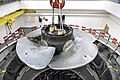 Kaplan Wasserkraftturbine.jpg 3,730 × 2,487; 4.89 MB
-
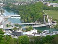 Kraftwerk-A4-Brücke-Schaffhausen.JPG 2,560 × 1,920; 1.13 MB
-
 Kraftwerk-Schaffhausen-1.JPG 2,048 × 1,536; 873 KB
-
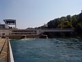 Kraftwerk-Schaffhausen.JPG 2,048 × 1,536; 812 KB
-
 Pumpspeicherwerk-Engeweiher-Schaffhausen.JPG 2,560 × 1,920; 2.35 MB
-
 Schaffhausen - Feuerthalen 2010-06-24 17-43-32.JPG 4,288 × 2,848; 5.51 MB
-
 Schaffhausen - Feuerthalen 2010-06-24 17-46-22.JPG 4,288 × 2,848; 6.7 MB
-
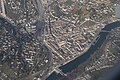 Schaffhausen aerial 1.jpg 6,000 × 4,000; 8 MB
-
 Schaffhausen-Rhein.JPG 2,242 × 1,518; 828 KB
-
 SICHT VON NEUHAUSEN NACH SCHAFFHAUSEN 3.9.2013 - panoramio.jpg 4,896 × 3,672; 3.46 MB


