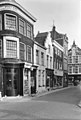
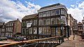
Category:Korte Dam 10, Schiedam
Jump to navigation
Jump to search
| Object location | | View all coordinates using: OpenStreetMap |
|---|
building in Schiedam, Netherlands  | |||||
| Upload media | |||||
| Instance of | |||||
|---|---|---|---|---|---|
| Location | Schiedam, South Holland, Netherlands | ||||
| Street address |
| ||||
| Located on street |
| ||||
| Heritage designation |
| ||||
 | |||||
|
This is a category about rijksmonument number 33147
|
| Address |
|
Media in category "Korte Dam 10, Schiedam"
The following 8 files are in this category, out of 8 total.
-
 Gevels - Schiedam - 20196753 - RCE.jpg 812 × 1,200; 188 KB
-
 GraphyArchy - Wikipedia 00341.jpg 3,000 × 4,500; 10.33 MB
-
 Hoek Nieuwe Sluisstraat - Schiedam - 20196754 - RCE.jpg 1,200 × 806; 194 KB
-
 Plafond en schouw achterkamer begane grond - Schiedam - 20196755 - RCE.jpg 786 × 1,200; 184 KB
-
 Plafond en schouw achterkamer begane grond - Schiedam - 20196756 - RCE.jpg 1,200 × 760; 179 KB
-
 Schiedam - Korte Dam 10.jpg 1,944 × 2,592; 1.27 MB
-
 Schiedam, Netherlands - panoramio (11).jpg 1,148 × 2,048; 468 KB
-
 Schiedam, Netherlands - panoramio (22).jpg 2,048 × 1,148; 520 KB


.jpg)
.jpg)