Category:Knaphill
Jump to navigation
Jump to search
English: Knaphill is a dispersed urban village in Surrey, UK. To the east is Woking, to the west, eventually, is Aldershot, while to the south and north on the A322 – which forms its effective western border – are Brookwood, and Bisley, respectively. It was part of the former Woking Urban District.
village in Surrey, England, UK  | |||||
| Upload media | |||||
| Instance of | |||||
|---|---|---|---|---|---|
| Location | Woking, Surrey, South East England, England | ||||
 | |||||
Subcategories
This category has the following 14 subcategories, out of 14 total.
A
- Anchor Inn, Knaphill (4 F)
B
- Bus stops in Knaphill (8 F)
- Buses in Knaphill (11 F)
K
- Knaphill Baptist Church (2 F)
- Knaphill Methodist Church (5 F)
N
- Nag's Head Inn, Knaphill (3 F)
P
R
- Royal Oak pub, Knaphill (4 F)
T
- The Crown pub, Knaphill (4 F)
W
- Wat Phra Dhammakaya London (14 F)
- Whitfield Court, Surrey (2 F)
Media in category "Knaphill"
The following 31 files are in this category, out of 31 total.
-
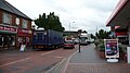 Badly parked lorries in Knaphill High Street.JPG 3,712 × 2,088; 3.14 MB
-
 Basingstoke Canal by Hermitage - geograph.org.uk - 820742.jpg 640 × 480; 146 KB
-
 Basingstoke Canal near St. Johns, Woking - geograph.org.uk - 22972.jpg 640 × 480; 168 KB
-
 Bisley Common 1 - geograph.org.uk - 1411577.jpg 640 × 480; 255 KB
-
 Bisley Common 2 - geograph.org.uk - 1411580.jpg 640 × 480; 258 KB
-
 Bridge over Blackhorse Road - geograph.org.uk - 45710.jpg 640 × 427; 111 KB
-
 Energy conservation in Woking - geograph.org.uk - 45728.jpg 640 × 427; 87 KB
-
-
 Garibaldi pub, 134 High Street, Knaphill (June 2015).jpg 4,200 × 3,200; 2.02 MB
-
 Houseboat on the Basingstoke Canal - geograph.org.uk - 45703.jpg 640 × 427; 95 KB
-

-
 Kiln Bridge, Basingstoke Canal - geograph.org.uk - 582740.jpg 640 × 529; 172 KB
-
 Knaphill Food ^ Wine, 5 High Street, Knaphill - geograph.org.uk - 2516534.jpg 835 × 1,024; 189 KB
-

-
 Knaphill village sign, High Street, Knaphill - geograph.org.uk - 2516509.jpg 796 × 1,024; 236 KB
-
 Locksley Drive, Knaphill - geograph.org.uk - 1655315.jpg 640 × 480; 152 KB
-
 Raglan Road, Knaphill (geograph 2765339).jpg 2,048 × 1,536; 1.41 MB
-
 Skandia Cowes Week 2004 car sticker and Knaphill Sainsbury's 2.JPG 2,048 × 1,536; 564 KB
-
 Skandia Cowes Week 2004 car sticker and Knaphill Sainsbury's.JPG 2,048 × 1,536; 449 KB
-
 Skandia Cowes Week 2004 car sticker.JPG 2,048 × 1,536; 395 KB
-
 The Beer's In^ - geograph.org.uk - 820773.jpg 640 × 480; 99 KB
-
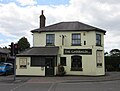
 The Garibaldi - geograph.org.uk - 1598205.jpg 640 × 480; 70 KB
-
 Bisley Common - geograph.org.uk - 58990.jpg 640 × 427; 86 KB
-
 Climbing the hill to Knaphill - geograph.org.uk - 45671.jpg 640 × 427; 87 KB
-
 Cycle crossing at Amstel Way - geograph.org.uk - 45721.jpg 640 × 427; 101 KB
-
 Inkerman Barracks - geograph.org.uk - 45718.jpg 640 × 427; 87 KB
-
 Kirkland Avenue, Goldsworth Park - geograph.org.uk - 45651.jpg 640 × 427; 114 KB
-
 Knaphill - geograph.org.uk - 45667.jpg 640 × 427; 74 KB
-
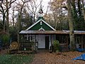
 Knaphill Garden Centre - geograph.org.uk - 45577.jpg 640 × 427; 79 KB
-
 Roundthorn Way, Goldsworth Park - geograph.org.uk - 45639.jpg 640 × 427; 90 KB
-
 Waterers Park, Knaphill - geograph.org.uk - 45572.jpg 640 × 427; 125 KB


.jpg)
.jpg)


,_High_Street,_Knaphill_-_geograph.org.uk_-_2516518.jpg)


.jpg)


