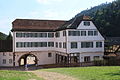
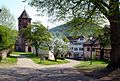
Category:Klosterhof 1 - Unteres Tor
Jump to navigation
Jump to search
| Object location | | View all coordinates using: OpenStreetMap |
|---|
Media in category "Klosterhof 1 - Unteres Tor"
The following 38 files are in this category, out of 38 total.
-
 Calw Hirsau - Klosterhof - 1Unteres Tor + 2Amtsdienerwohngebäude 01 ies.jpg 3,744 × 5,616; 10.65 MB
-
 Calw Hirsau - Klosterhof - 1Unteres Tor + 2Amtsdienerwohngebäude 02 ies.jpg 3,744 × 5,616; 13.09 MB
-
 Calw Hirsau - Klosterhof - 1Unteres Tor + 2Amtsdienerwohngebäude 03 ies.jpg 5,616 × 3,744; 14.4 MB
-
 Calw Hirsau - Klosterhof - 1Unteres Tor + Wildbader Straße 01 ies.jpg 5,616 × 3,744; 17.14 MB
-
 Calw Hirsau - Klosterhof - 1Unteres Tor + Wildbader Straße 02 ies.jpg 5,616 × 3,744; 16.95 MB
-
 Calw Hirsau - Klosterhof - 1Unteres Tor + Wirtschaftshof + Wildbader Straße 01 ies.jpg 5,616 × 3,744; 17.26 MB
-
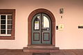
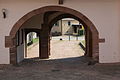
 Calw Hirsau - Klosterhof - 1Unteres Tor 01 ies.jpg 5,616 × 3,744; 17.38 MB
-
 Calw Hirsau - Klosterhof - 1Unteres Tor 02 ies.jpg 5,616 × 3,744; 13.42 MB
-
 Calw Hirsau - Klosterhof - 1Unteres Tor 03 ies.jpg 3,744 × 5,616; 11.55 MB
-
 Calw Hirsau - Klosterhof - 1Unteres Tor 04 ies.jpg 3,744 × 5,616; 14.97 MB
-
 Calw Hirsau - Klosterhof - 1Unteres Tor 05 ies.jpg 5,616 × 3,744; 14.34 MB
-
 Calw Hirsau - Klosterhof - 1Unteres Tor 06 ies.jpg 5,616 × 3,744; 13.4 MB
-
 Calw Hirsau - Klosterhof - 1Unteres Tor 07 ies.jpg 5,616 × 3,744; 15.4 MB
-
 Calw Hirsau - Klosterhof - 1Unteres Tor 08 ies.jpg 3,744 × 5,616; 14.55 MB
-
 Calw Hirsau - Klosterhof - 1Unteres Tor 09 ies.jpg 5,616 × 3,744; 14.15 MB
-
 Calw Hirsau - Klosterhof - 1Unteres Tor 10 ies.jpg 5,616 × 3,744; 15.28 MB
-
 Calw Hirsau - Klosterhof - 1Unteres Tor 11 ies.jpg 5,616 × 3,744; 21.14 MB
-
 Calw Hirsau - Klosterhof - 1Unteres Tor 12 ies.jpg 5,616 × 3,744; 17.69 MB
-
 Calw Hirsau - Klosterhof - 1Unteres Tor 13 ies.jpg 5,616 × 3,744; 14.66 MB
-
 Calw Hirsau - Klosterhof - 1Unteres Tor 14 ies.jpg 5,616 × 3,744; 11.64 MB
-

-
 Calw Hirsau - Klosterhof - 2Amtsdienerwohngebäude + 1Unteres Tor 01 ies.jpg 5,616 × 3,744; 15.43 MB
-
 Calw Hirsau - Klosterhof - 2Amtsdienerwohngebäude 01 ies.jpg 5,616 × 3,744; 15.24 MB
-
 Calw Hirsau - Klosterhof 04 ies.jpg 5,616 × 3,744; 15.97 MB
-
 Calw Hirsau - Wildbader Straße + Schafe 01 ies.jpg 5,616 × 3,744; 17.03 MB
-
 Calw Hirsau - Wildbader Straße + Schafe 03 ies.jpg 5,616 × 3,744; 16.24 MB
-
 Calw-Hirsau Kloster Sueddtor.jpg 2,432 × 1,647; 3.01 MB
-
 Calw-Hirsau Kloster Torhaus.jpg 2,303 × 1,591; 2.87 MB
-
 Calw-Hirsau Klostergebaeude.jpg 2,460 × 1,654; 3.77 MB
-
 Hirsau 2014 0002.JPG 3,072 × 2,304; 1.15 MB
-
 Hirsau 2014 0020.JPG 3,072 × 2,304; 1.45 MB
-
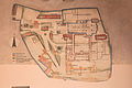
 Hirsau Karte Bausubstanz.jpg 1,449 × 1,055; 728 KB
-
 Hirsau kloster 2.jpg 2,048 × 1,536; 1.38 MB
-
 Hirsau Wagenhaus und Fruchtkasten.jpg 3,264 × 2,448; 3.93 MB
-
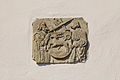
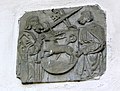 Hirsau Wappenrelief.jpg 2,741 × 2,077; 2.53 MB
-
 KlosterHirsau-Torhaus.jpg 2,235 × 1,492; 886 KB
-
 Landappbw 504423 1820 Unteres Tor Kloster Hirsau Hirsau.jpg 3,264 × 1,840; 949 KB
-
 Monastery Hirsau - Benediktinerkloster Hirsau - panoramio - Qwesy (1).jpg 3,072 × 2,304; 3.35 MB


.jpg)