Category:Klärschlammberg Bottrop
Jump to navigation
Jump to search
| Object location | | View all coordinates using: OpenStreetMap |
|---|
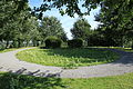
English: Klärschlammberg Bottrop is a naturalised hill made of the sludge from the close-by wastewater treatment plant in Bottrop
Subcategories
This category has only the following subcategory.
V
Media in category "Klärschlammberg Bottrop"
The following 4 files are in this category, out of 4 total.
-
 Bottrop - In der Weilheimer Mark - Klärschlammberg 01 ies.jpg 5,616 × 3,744; 12.47 MB
-
 Bottrop - In der Weilheimer Mark - Klärschlammberg 02 ies.jpg 5,616 × 3,744; 9.61 MB
-
 Bottrop - In der Weilheimer Mark - Klärschlammberg 03 ies.jpg 5,616 × 3,744; 9.77 MB
-
 Bottrop - In der Weilheimer Mark - Klärschlammberg 04 ies.jpg 5,616 × 3,744; 8.99 MB


