Category:Kilfinane
Jump to navigation
Jump to search
town in County Limerick, Ireland  | |||||
| Upload media | |||||
| Instance of | |||||
|---|---|---|---|---|---|
| Location | County Limerick, Munster, Ireland | ||||
| Elevation above sea level |
| ||||
 | |||||
English: Kilfinane (Cill Fhíonáin in Irish) is a small market town in southeast County Limerick, Ireland. The Town's name comes from the Irish words "Cill" (church) and "Fhíonáin" (Finian), making its meaning "Church of Saint Finian." Kilfinane is located approximately 40 km southeast of [Cork, and approximately 70 km north-northwest of Cork. The town has a population of approximately 750 people.
Lietuvių: Kilfainanas (air. Cill Fhíonáin, ). Miestelyje gyvena maždaug 750 žmonių.
Nederlands: Kilfinane is een plaats in het Ierse graafschap County Limerick. De plaats telt 750 inwoners.
Media in category "Kilfinane"
The following 12 files are in this category, out of 12 total.
-
 Captains Lane (L1521) in Kilfinane - geograph.org.uk - 5587900.jpg 4,000 × 3,000; 4.74 MB
-
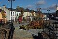 Kilfinane village centre. - geograph.org.uk - 1534880.jpg 640 × 428; 85 KB
-
 Kilfinane.jpg 2,362 × 1,574; 726 KB
-
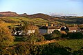 KilfinaneView.jpg 404 × 268; 41 KB
-
 Main Street (R517) in Kilfinane - geograph.org.uk - 5587881.jpg 4,000 × 3,000; 2.91 MB
-
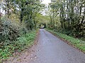
 Road (L1521) Ballinlyna Upper - geograph.org.uk - 5587907.jpg 4,000 × 3,000; 4.46 MB
-
 Road (L1521) between Ballinlyna Upper and Lower - geograph.org.uk - 5587904.jpg 4,000 × 3,000; 4.32 MB
-
 Road from Boshnetstown to L1511 - geograph.org.uk - 5587866.jpg 4,000 × 3,000; 4.53 MB
-
 Road near Boshnetstown - geograph.org.uk - 5587861.jpg 4,000 × 3,000; 4.07 MB
-
 Road to The Field of Dreams Sanctuary at Kilfinane - geograph.org.uk - 5587853.jpg 4,000 × 3,000; 4.1 MB
-
 Silver Olive Community Art Centre in Kilfinane - geograph.org.uk - 5587890.jpg 4,000 × 3,000; 3.3 MB
-
 West End (R517) in Kilfinane - geograph.org.uk - 5587884.jpg 4,000 × 3,000; 2.48 MB
_in_Kilfinane_-_geograph.org.uk_-_5587900.jpg)


_in_Kilfinane_-_geograph.org.uk_-_5587881.jpg)
_Ballinlyna_Upper_-_geograph.org.uk_-_5587907.jpg)
_between_Ballinlyna_Upper_and_Lower_-_geograph.org.uk_-_5587904.jpg)


_in_Kilfinane_-_geograph.org.uk_-_5587884.jpg)