Category:Kildorrery
Jump to navigation
Jump to search
English: Kildorrery (Cill Dairbhre in Irish: "oak-forest church") is a village in north County Cork, Ireland. It lies at the crossroads of the N73 road from Mallow to Mitchelstown and the R512 from Kilmallock to Fermoy.
village in County Cork, Ireland  | |||||
| Upload media | |||||
| Instance of | |||||
|---|---|---|---|---|---|
| Location | County Cork, Munster, Ireland | ||||
| Population |
| ||||
 | |||||
Media in category "Kildorrery"
The following 13 files are in this category, out of 13 total.
-
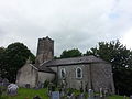 Kildorrery Church.jpg 3,264 × 2,448; 2.3 MB
-
 Kildorrery Village - geograph.org.uk - 1552039.jpg 640 × 425; 62 KB
-
 Kildorrery, cottage - geograph.org.uk - 1553137.jpg 640 × 425; 71 KB
-
 Kildorrery, flooded fields - geograph.org.uk - 1571586.jpg 640 × 425; 56 KB
-
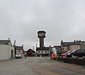
 Kildorrery, microwave tower - geograph.org.uk - 1552167.jpg 640 × 425; 47 KB
-
 Kildorrery, N73 road junction. - geograph.org.uk - 1553141.jpg 640 × 425; 74 KB
-
 Kildorrery, tourist information. - geograph.org.uk - 1553134.jpg 640 × 415; 50 KB
-
 Kildorrery, Water tower.JPG 4,292 × 3,808; 3.06 MB
-
 Kildorrery,Tree Nursery - geograph.org.uk - 1571571.jpg 640 × 425; 104 KB
-
 Kildorrery1.JPG 2,630 × 1,505; 591 KB
-
 Kildorrery2.JPG 2,630 × 1,505; 921 KB
-
 Kildorrery3.JPG 3,888 × 2,592; 1.67 MB
-
 Road works - geograph.org.uk - 553756.jpg 640 × 480; 68 KB


